Freycinet National Park is a national park on the east coast of Tasmania, Australia, 125 km northeast of Hobart. It occupies a large part of the Freycinet Peninsula, named after French navigator Louis de Freycinet, and Schouten Island. Founded in 1916, it is Tasmania's oldest park, along with Mount Field National Park. Bordering the national park is the small settlement of Coles Bay, and the largest nearby town is Swansea. Freycinet contains part of the rugged Tasmanian coastline and includes the secluded Wineglass Bay. Features of the park include its red and pink granite formations and a series of jagged granite peaks in a line, called "The Hazards".

Mount Wellington, officially kunanyi / Mount Wellington, incorporating its Palawa kani name, is a mountain in the southeast coastal region of Tasmania, Australia. It is the summit of the Wellington Range and is within the Wellington Park reserve. Located at the foothills of the mountain is much of Tasmania's capital city, Hobart.

Lake St Clair or leeawulenna is a natural freshwater lake located in the Central Highlands area of Tasmania, Australia. The lake forms the southern end of the Cradle Mountain-Lake St Clair National Park. It has an area of approximately 45 square kilometres (17 sq mi), and a maximum depth of 160 metres (520 ft), making it Australia's deepest lake.

Glamorgan-Spring Bay Council is a local government body in Tasmania, situated on the central east coast of the state. Glamorgan-Spring Bay is classified as a rural local government area and has a population of 4,528, the major towns of the region include Bicheno, Orford and Triabunna with Swansea the principal town.

The West Coast Range is a mountain range located in the West Coast region of Tasmania, Australia.

The West Coast of Tasmania is mainly isolated rough country, associated with wilderness, mining and tourism. It served as the location of an early convict settlement in the early history of Van Diemen's Land, and contrasts sharply with the more developed and populous northern and eastern parts of the island state.
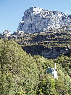
Frenchmans Cap is a mountain in the West Coast region of Tasmania, Australia. The mountain is situated in the Franklin-Gordon Wild Rivers National Park.
Mount Read is a mountain located in the West Coast region of Tasmania, Australia, and is at the north west edge of the West Coast Range.
Mount Sedgwick is a mountain located within the West Coast Range, in the West Coast region of Tasmania, Australia.

The Freycinet Peninsula is a large peninsula located on the eastern coast of Tasmania, Australia. The peninsula is located north of Schouten Island and is contained within the Freycinet National Park.

Schouten Island, part of the Schouten Island Group, is an island with an area of approximately 28 square kilometres (11 sq mi) lying close to the eastern coast of Tasmania, Australia, located 1.6 kilometres (0.99 mi) south of the Freycinet Peninsula and is a part of Freycinet National Park. The Paredarerme name for the island is Tiggana marraboona.

Mount Murchison is a mountain on the West Coast Range, located in the West Coast region of Tasmania, Australia.
Mount Dundas is a mountain located in the West Coast region of Tasmania, Australia. The mountain is situated at the north west edge of the West Coast Range.
The Sticht Range is a mountain range located in the West Coast region of Tasmania, Australia. The range runs between two tributaries of the Eldon River and is located within the eastern part of the West Coast Range and has an unnamed peak with an elevation of 1,080 metres (3,540 ft) above sea level.
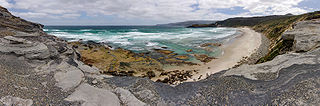
The South Coast Track is a bushwalking track located in the South Coast region of Tasmania, Australia. The 85-kilometre (53 mi) track traverses remote wilderness within the Southwest National Park, part of the Tasmanian Wilderness World Heritage Site, and is managed as a wilderness walk. The Tasmanian Parks & Wildlife Service recommend that experienced bushwalkers can take six-to-eight days to cover the track in one direction.
The Taillefer Rocks, part of the Schouten Island Group, are three small, rugged, granite islands, with a combined area of approximately 15 hectares lying close to the eastern coast of Tasmania, Australia, near the Freycinet Peninsula and lies within the Freycinet National Park.

Coles Bay is an Australian town on the east Coast of Tasmania 192 km north-east of Hobart and 209 km south-east of Launceston, being the main entrance point for visitors to the Freycinet National Park.
Great Oyster Bay is a broad and sheltered bay on the east coast of Tasmania, Australia which opens onto the Tasman Sea. The Tasman Highway runs close to the West Coast of the bay with views of the granite peaks of the Hazards and Schouten Island of the Freycinet Peninsula which are incorporated in the Freycinet National Park.

The Tyndall Range, commonly called The Tyndalls, is a mountain range that is part of the West Coast Range located in the Western region of Tasmania, Australia.

Robert William Morris-Nunn is an Australian architect.

