
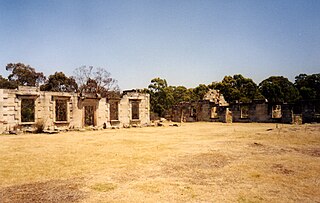
The Tasman National Park is a national park in eastern Tasmania, Australia, approximately 56 kilometres (35 mi) east of Hobart. The 107.5-square-kilometre (41.5 sq mi) park is situated on part of both the Forestier and Tasman peninsulas and encompasses all of Tasman Island.

The Tasman Peninsula, officially Turrakana / Tasman Peninsula, is a peninsula located in south-east Tasmania, Australia, approximately 75 km (47 mi) by the Arthur Highway, south-east of Hobart.

Bruny Island is a 362-square-kilometre (140 sq mi) island located off the southeastern coast of Tasmania, Australia. The island is separated from the Tasmanian mainland by the D'Entrecasteaux Channel, and its east coast lies within the Tasman Sea. Located to the island's northeast Storm Bay, is the river mouth to the Derwent River estuary, and serves as the main port of Hobart, Tasmania's capital city. Both the island and the channel are named after French explorer, Antoine Bruni d'Entrecasteaux. Its traditional Aboriginal name is lunawanna-allonah, which survives as the name of two island settlements, Alonnah and Lunawanna.

Maria Island or wukaluwikiwayna in palawa kani is a mountainous island located in the Tasman Sea, off the east coast of Tasmania, Australia. The 115.5-square-kilometre (44.6 sq mi) island is contained within the Maria Island National Park, which includes a marine area of 18.78 square kilometres (7.25 sq mi) off the island's northwest coast. The island is about 20 kilometres (12 mi) in length from north to south and, at its widest, is about 13 kilometres (8.1 mi) west to east. At its closest point, Point Lesueur, the island lies approximately 4 kilometres (2.5 mi) off the east coast of Tasmania.
Saltwater River is a rural locality in the local government area (LGA) of Tasman in the South-east LGA region of Tasmania. The locality is about 14 kilometres (8.7 mi) north of the town of Nubeena. The 2016 census has a population of 123 for the state suburb of Saltwater River.
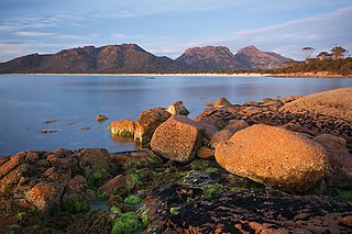
The Hazards are a mountain range located in the Freycinet National Park on the east coast of Tasmania, Australia. The range is positioned between Coles Bay and Wineglass Bay and are said to be named after local whaler, African-American Captain Richard Hazard. The range consists of 5 mountains; Mayson, Amos, Dove, Baudin and Parson.

Schouten Island, part of the Schouten Island Group, is an island with an area of approximately 28 square kilometres (11 sq mi) lying close to the eastern coast of Tasmania, Australia, located 1.6 kilometres (0.99 mi) south of the Freycinet Peninsula and is a part of Freycinet National Park. The palawa kani place name for the island is mayaluwarana.
Eaglehawk Neck, officially Teralina / Eaglehawk Neck, is a narrow isthmus that connects the Tasman Peninsula with the Forestier Peninsula and hence to the rest of Tasmania, Australia.

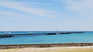
Triabunna is a rural residential locality in the local government area (LGA) of Glamorgan–Spring Bay in the South-east LGA region of Tasmania. The locality is about 86 kilometres (53 mi) north-east of the city of Hobart. The 2021 census has a population of 905 for the state suburb of Triabunna.

The Nuggets is a close group of four granite islets, with a combined area of 6.76 hectares, in south-eastern Australia. They lie close to the eastern coast of Tasmania near the Freycinet Peninsula., and are near Cape Tourville, about 7 km north of Wineglass Bay and about 22 km north of Schouten Island.

Refuge Island is a flat granite island, with an area of about 6 ha, in south-eastern Australia. It is part of the Schouten Island Group, lying close to the eastern coast of Tasmania near the Freycinet Peninsula and is part of the Freycinet National Park.

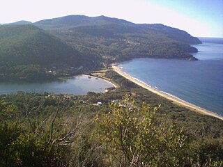
Coles Bay is an Australian town on the east Coast of Tasmania 192 km north-east of Hobart and 173 km south-east of Launceston, being the main entrance point for visitors to the Freycinet National Park.

Great Oyster Bay is a broad and sheltered bay on the east coast of Tasmania, Australia which opens onto the Tasman Sea. The Tasman Highway runs close to the West Coast of the bay with views of the granite peaks of the Hazards and Schouten Island of the Freycinet Peninsula which are incorporated in the Freycinet National Park.

Jussieu Peninsula is a peninsula located at the south east end of Eyre Peninsula in South Australia. It is bounded by Proper Bay and Spalding Cove within the natural harbour known as Port Lincoln to the north, Spencer Gulf to the east and the Great Australian Bight to the south. While it was first explored and mapped by Matthew Flinders during February 1802, Flinders did not name it. In 1913, the name proposed by François Péron and Louis de Freycinet from Baudin's expedition when it visited later in 1802 was declared as the peninsula's official name by the Government of South Australia. Jussieu refers to the French botanist, Antoine Laurent de Jussieu. While parts of its surface have been cleared and used for agricultural purposes in the past, it is currently occupied by two protected areas: the Lincoln National Park and the Memory Cove Wilderness Protection Area.
Rivoli Bay is a bay located on the south-east coast of the Australian state of South Australia, about 311 kilometres south-southeast of the state capital of Adelaide and about 65 kilometres northwest by west of the regional centre of Mount Gambier. It was named in 1802 by the Baudin expedition of 1800–03 after André Masséna, the Duke of Rivoli and Marshal of France. It is one of four 'historic bays' located on the South Australian coast.
Cape Raoul is a rural locality and a natural feature in the local government area of Tasman in the South-east region of Tasmania. It is located about 13 kilometres (8.1 mi) south of the town of Nubeena. The 2016 census determined a population of nil for the state suburb of Cape Raoul.

Cape Pillar is a rural locality in the local government area (LGA) of Tasman in the South-east LGA region of Tasmania. The locality is about 27 kilometres (17 mi) south-east of the town of Nubeena. The 2016 census recorded a population of 4 for the state suburb of Cape Pillar. It is on the Tasman Peninsula in the Tasman National Park, adjacent to Tasman Island.

Sleaford Bay is a bay located in the Australian state of South Australia on the southern coast of Eyre Peninsula. It was named by the British navigator, Matthew Flinders in 1802.
South Bruny is a rural locality on Bruny Island in the local government area of Kingborough in the Hobart region of Tasmania. It is located about 14 kilometres (8.7 mi) south of the town of Alonnah, the largest town on the island. The 2016 census determined a population of 84 for the state suburb of South Bruny.
Friendly Beaches is a rural locality in the local government area of Glamorgan–Spring Bay in the South-east region of Tasmania. The locality is about 91 kilometres (57 mi) north-east of the town of Swansea. The 2016 census has a population of 10 for the state suburb of Friendly Beaches.


