Protected areas of Tasmania consist of protected areas located within Tasmania and its immediate onshore waters, including Macquarie Island. It includes areas of crown land managed by Tasmanian Government agencies as well as private reserves. As of 2016, 52% of Tasmania's land area has some form of reservation classification, the majority is managed by the Tasmania Parks & Wildlife Service. Marine protected areas cover about 7.9% of state waters.

The River Derwent, also known as timtumili minanya in palawa kani, is a significant river and tidal estuary in Tasmania, Australia. It begins its journey as a freshwater river in the Central Highlands at Lake St Clair, descending over 700 metres (2,300 ft) across a distance of more than 200 kilometres (120 mi). At the settlement of New Norfolk in the Derwent Valley its waters become brackish, flowing through Hobart, the capital city of Tasmania, its seawater estuary eventually empties into Storm Bay and the Tasman Sea.

Bruny Island is a 362-square-kilometre (140 sq mi) island located off the southeastern coast of Tasmania, Australia. The island is separated from the Tasmanian mainland by the D'Entrecasteaux Channel, and its east coast lies within the Tasman Sea. Located to the island's northeast Storm Bay, is the river mouth to the Derwent River estuary, and serves as the main port of Hobart, Tasmania's capital city. Both the island and the channel are named after French explorer, Antoine Bruni d'Entrecasteaux. Its traditional Aboriginal name is lunawanna-allonah, which survives as the name of two island settlements, Alonnah and Lunawanna.

Flinders Island, the largest island in the Furneaux Group, is a 1,367-square-kilometre (528 sq mi) island in the Bass Strait, northeast of the island of Tasmania. Today Flinders Island is part of the state of Tasmania, Australia. It is 54 kilometres (34 mi) from Cape Portland and is located on 40° south, a zone known as the Roaring Forties.

St Helens is the largest town on the north-east coast of Tasmania, Australia, on Georges Bay. It is known as the game fishing capital of Tasmania and is also renowned for its oysters. It is located on the Tasman Highway, about 160 km east of Tasmania's second largest city, Launceston. In the early 2000s, the town was one of the fastest growing areas of Tasmania, and reached a population of 2049 at the 2006 census. By the time of the 2021 census, it had a population of 2,206.
Marion Bay is a rural / residential locality in the local government area (LGA) of Sorell in the South-east LGA region of Tasmania. The locality is about 27 kilometres (17 mi) east of the town of Sorell. The 2016 census recorded a population of 72 for the state suburb of Marion Bay. Marion Bay is also a large bay on the south-east coast of Tasmania. Its south-western shore is contained by the Marion Bay Important Bird Area.

Cape Barren Island, officially truwana / Cape Barren Island, is a 478-square-kilometre (185 sq mi) island in Bass Strait, off the north-east coast of Tasmania, Australia. It is the second-largest island of the Furneaux Group, with the larger Flinders Island to the north, and the smaller Clarke Island to the south. The highest point on the island is Mount Munro at 715 metres (2,346 ft). Mount Munro is named after James Munro, a former convict turned sealer who, from the 1820s, lived for more than 20 years with various indigenous women on nearby Preservation Island.

Orford is a seaside village located on the east coast of Tasmania, Australia, approximately 73 kilometres (45 mi) north-east of the state-capital of Hobart. Situated on Paredarerme pungenna country, and nestled around the mouth of the Prosser River, the village sits on the southern edge of Prosser Bay, with the Mercury Passage stretching out beyond the bay’s waters. At the 2021 census, Orford had a population of 685, though the population swells significantly during holiday periods.
The Clarke Island, also known by its Indigenous name of lungtalanana, part of the Furneaux Group, is an 82-square-kilometre (32 sq mi) island in Bass Strait, south of Cape Barren Island, about 24 kilometres (15 mi) off the northeast coast of Tasmania, Australia. Banks Strait separates the island from Cape Portland on the mainland. Clarke Island is the third-largest island in the Furneaux Group, and Tasmania's eighth largest island.

Tasmania Parks and Wildlife Service is the government body responsible for managing protected areas of Tasmania on public land, such as national parks, historic sites and regional reserves. Historically it has also had responsibility for managing wildlife, including game.
Cloudy Bay is located at the southernmost end of Bruny Island in the Australian state of Tasmania, inside South Bruny National Park.

Port Davey is an oceanic inlet located in the south west region of Tasmania, Australia.

Binalong Bay is a rural locality in the local government area (LGA) of Break O'Day in the North-east LGA region of Tasmania. The locality is about 12 kilometres (7.5 mi) north-east of the town of St Helens. The 2016 census recorded a population of 290 for the state suburb of Binalong Bay.
The Anderson Island, also known as Woody Island, part of the Tin Kettle Island Group of the Furneaux Group, is a 166-hectare (410-acre) granite island, located in Bass Strait, lying northeast of Tasmania, in south-eastern Australia. Anderson Island lies between Flinders and Cape Barren Islands and is partly a pastoral lease used for grazing sheep and cattle. The island is joined at low tide to nearby Little Anderson and Tin Kettle Islands by extensive intertidal mudflats. The island is supposed to be named after John Anderson, a sealer living on the island by 1842.

The Babel Island, part of the Babel Group within the Furneaux Group, is a 440-hectare (1,100-acre) granite island, located in Bass Strait, lying off the east coast of Flinders Island, Tasmania, south of Victoria, Australia. The privately owned island was named by Matthew Flinders from the noises made by the seabirds there.
The Low Rocky Point is a location on the south west coast of Tasmania and Australia, that is used as a location for weather forecasting. It is almost due west of Hobart, it is south of Point Hibbs and north of South West Cape.

The Friars are four steep dolerite rocks, with a combined area of about 17 ha, in south-eastern Australia. They are part of the Actaeon Island Group, lying close to the south-eastern coast of Tasmania, at the southern entrance to the D'Entrecasteaux Channel between Bruny Island and the mainland. They form part of South Bruny National Park.

Cockle Creek is the farthest point south one can drive in Australia. It is located on Recherche Bay on the edge of the Southwest National Park, part of the Tasmanian Wilderness World Heritage Area.

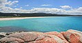
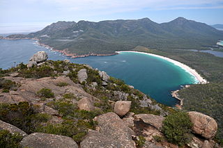
Great Oyster Bay is a broad and sheltered bay on the east coast of Tasmania, Australia which opens onto the Tasman Sea. The Tasman Highway runs close to the West Coast of the bay with views of the granite peaks of the Hazards and Schouten Island of the Freycinet Peninsula which are incorporated in the Freycinet National Park.
The Tasmanian temperate forests is a temperate broadleaf and mixed forests ecoregion in Australia. The ecoregion occupies the eastern portion of the island of Tasmania, which lies south of the Australian mainland.