The Oyster Rocks are a close pair of small granite islands, with a combined area of about 6 ha, in south-eastern Australia. They are part of Tasmania’s Tin Kettle Island Group, lying in eastern Bass Strait between Flinders and Cape Barren Islands in the Furneaux Group. They are a conservation area. The islands are part of the Franklin Sound Islands Important Bird Area, identified as such by BirdLife International because it holds over 1% of the world populations of six bird species.

Night Island is a small granite island, with an area of 2.59 ha, is part of the Preservation Island Group, lying in eastern Bass Strait south of Cape Barren Island in the Furneaux Group, Tasmania, Australia.
Rum Island is a granite island, with an area of 13.5 ha, just south of Preservation Island in south-eastern Australia. It is part of Tasmania’s Preservation Island Group, lying in eastern Bass Strait south-west of Cape Barren Island in the Furneaux Group. It is part of the Sydney Cove historic site.
Key Island, with the adjacent Key Reef, is a granite island, with an area of 6 ha, in south-eastern Australia. It is part of Tasmania’s Long Island Group, lying in eastern Bass Strait west of Cape Barren Island in the Furneaux Group. The ketch 'Grace Victoria Holyman' was wrecked near here in Thunder & Lightning Bay in 1897.
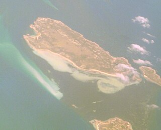
Little Anderson Island is an island, with an area of 13 ha, in south-eastern Australia. It is part of Tasmania’s Tin Kettle Island Group, lying in eastern Bass Strait between Flinders and Cape Barren Islands in the Furneaux Group. The island is joined at low tide to nearby Anderson and Tin Kettle Islands by extensive intertidal mudflats. The island is part of the Franklin Sound Islands Important Bird Area, identified as such by BirdLife International because it holds over 1% of the world populations of six bird species.
Mid Woody Islet is a small island, with an area of 0.66 ha, in south-eastern Australia. It is part of Tasmania’s Tin Kettle Island Group, lying in eastern Bass Strait between Flinders and Cape Barren Islands in the Furneaux Group. The island is joined at low tide to nearby Anderson, Little Anderson and Tin Kettle Islands by extensive intertidal mudflats. The island is part of the Franklin Sound Islands Important Bird Area, identified as such by BirdLife International because it holds over 1% of the world populations of six bird species.

Neds Reef is a group of three small granite islets, joined at low tide by extensive mudflats, with a combined area of about 3 ha, in south-eastern Australia. They are part of Tasmania’s Tin Kettle Island Group, lying in eastern Bass Strait between Flinders and Cape Barren Islands in the Furneaux Group. The reef is part of the Franklin Sound Islands Important Bird Area, identified as such by BirdLife International because it holds over 1% of the world populations of six bird species.
South East Great Dog Islet is a small granite island, with an area of 0.6 ha, in south-eastern Australia. It is part of Tasmania’s Great Dog Island Group, lying in eastern Bass Strait between Flinders and Cape Barren Islands in the Furneaux Group. It is very close to the south-eastern end of Great Dog Island.
Samphire Island is a small shell-grit island, with an area of 3.3 ha, in south-eastern Australia. It is part of Tasmania’s Great Dog Island Group, lying in eastern Bass Strait between Flinders and Cape Barren Islands in the Furneaux Group. It is surrounded by mudflats at low tide.

Fisher Island is a small granite island, with an area of 0.9 ha, in south-eastern Australia. It is part of Tasmania’s Great Dog Island Group, lying in eastern Bass Strait between Flinders and Cape Barren Islands in the Furneaux Group. It is the site of a long-term, ongoing study of short-tailed shearwaters.

Vansittart Island, also known as Gun Carriage Island, is a granite island with an area of 800 hectares. The island is part of Tasmania's Vansittart Island Group, lying in eastern Bass Strait between Flinders and Cape Barren Islands in the Furneaux Group.
Puncheon Island is an island, with an area of 17.56 ha, in south-eastern Australia. It is part of Tasmania’s Vansittart Island Group, lying in eastern Bass Strait between Flinders and Cape Barren Islands in the Furneaux Group. It is surrounded by mudflats. It is privately owned and used for farming. It has been extensively burnt and grazed.
Pelican Island is an island, with an area of 6.8 ha including an associated reef joined to it at low tide, in south-eastern Australia. It is part of Tasmania’s Vansittart Island Group, lying in eastern Bass Strait between Flinders and Cape Barren Islands in the Furneaux Group. Until 1984 it was leased for grazing. The island is part of the Franklin Sound Islands Important Bird Area, identified as such by BirdLife International because it holds over 1% of the world populations of six bird species.
The Low Islets are two small, flat, adjacent, granite islands, with a combined area of about 2 ha, in south-eastern Australia. They are part of Tasmania’s Prime Seal Island Group, lying in eastern Bass Strait west of Flinders in the Furneaux Group. The larger of the two islets has been used for grazing sheep, cattle and horses.

The Nuggets is a close group of four granite islets, with a combined area of 6.76 hectares, in south-eastern Australia. They lie close to the eastern coast of Tasmania near the Freycinet Peninsula., and are near Cape Tourville, about 7 km north of Wineglass Bay and about 22 km north of Schouten Island.
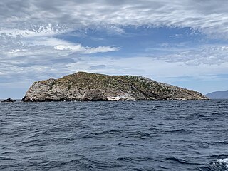
Ile des Phoques is a rugged granite island, with an area of 8 ha, part of the Schouten Island Group, lying close to the eastern coast of Tasmania, Australia near the Freycinet Peninsula.

Refuge Island is a flat granite island, with an area of about 6 ha, in south-eastern Australia. It is part of the Schouten Island Group, lying close to the eastern coast of Tasmania near the Freycinet Peninsula and is part of the Freycinet National Park.
Little Christmas Island is a small, flat, granite island, with an area of about 2 ha, in south-eastern Australia. It is part of the Schouten Island Group, lying close to the eastern coast of Tasmania near the Freycinet Peninsula. It is close to the Tasmanian mainland and, at low tide, is separated only by a shallow and narrow stretch of water.
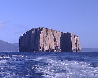
Hippolyte Rocks is a small granite island, with an area of 5.3 ha, in south-eastern Australia. It is part of the Tasman Island Group, lying close to the south-eastern coast of Tasmania around the Tasman Peninsula. It has a flat top and is surrounded by steep cliffs up to 65 m in height. It is part of the Tasman National Park.

Sloping Island, incorporating the adjacent Sloping Reef, is an island nature reserve, with an area of 117 ha, in Tasmania in south-eastern Australia. It is part of the Sloping Island Group, lying close to the south-eastern coast of Tasmania around the Tasman and Forestier Peninsulas.
