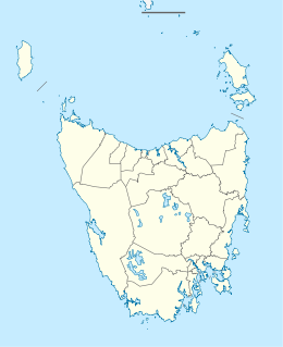
Tasmania is an island state of Australia. It is located 240 km (150 mi) to the south of the Australian mainland, separated from it by Bass Strait. The state encompasses the main island of Tasmania, the 26th-largest island in the world, and the surrounding 1000 islands. It is Australia's least populated state, with 541,965 residents as of March 2021. The state capital and largest city is Hobart, with around 40 percent of the population living in the Greater Hobart area.
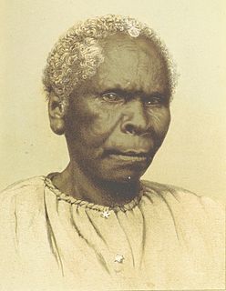
Truganini was a woman who was, perhaps incorrectly, considered by European colonists to have been the last full blood Aboriginal Tasmanian. Aboriginal Tasmanians maintain their culture and identity to the present day.

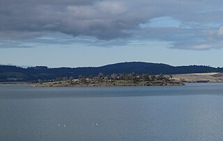
Bruny Island is a 362-square-kilometre (140 sq mi) island located off the south-eastern coast of Tasmania, Australia. The island is separated from the Tasmanian mainland by the D'Entrecasteaux Channel, and its east coast lies within the Tasman Sea. Storm Bay is located to the island's northeast. Both the island and the channel are named after French explorer, Antoine Bruni d'Entrecasteaux. Its traditional Aboriginal name is lunawanna-allonah, which survives as the name of two island settlements, Alonnah and Lunawanna.

Recherche Bay is an oceanic embayment, part of which is listed on the National Heritage Register, located on the extreme south-eastern corner of Tasmania, Australia. It was a landing place of the d’Entrecasteaux expedition to find missing explorer La Pérouse. It is named in honour of the Recherche, one of the expedition's ships. The Nuenonne name for the bay is Leillateah.

The D'Entrecasteaux Channel is a body of water located between Bruny Island and the south-east of the mainland of Tasmania, Australia. The channel is the mouth for the estuaries of the Derwent and the Huon Rivers and empties into the Tasman Sea of the South Pacific Ocean. It was sighted by Abel Tasman in 1642 and surveyed in 1792 by Bruni d'Entrecasteaux.
Alonnah is a rural locality on Bruny Island in the local government area (LGA) of Kingborough in the Hobart LGA region of Tasmania. The locality is about 60 kilometres (37 mi) south of the town of Kingston. The 2016 census provides a population of 137 for the state suburb of Alonnah.
Huon Island is an island with an area of 47 hectares in south-eastern Australia. It is part of the Partridge Island Group, lying close to the south-eastern coast of Tasmania, in the D'Entrecasteaux Channel between Bruny Island and the mainland. The island has a small human population and has been subjected to intensive agricultural activities in the past. The Nuenonne name of the island is Prahree.
Sloping Island, incorporating the adjacent Sloping Reef, is an island nature reserve, with an area of 117 ha, in Tasmania in south-eastern Australia. It is part of the Sloping Island Group, lying close to the south-eastern coast of Tasmania around the Tasman and Forestier Peninsulas.

Smooth Island, is a privately owned island with an area of 59.31 ha lying close to the south-eastern coast of Tasmania, Australia. The island is part of the Sloping Island Group situated in Norfolk Bay and surrounded by the Tasman and Forestier Peninsulas. The towns Dunalley and Murdunna are nearby. Smooth Island differs from other Tasmanian islands as it has an unencumbered freehold title down to the high-water mark.
Green Island is a small island nature reserve with an area of 4.17 ha close to the south-eastern coast of Tasmania, Australia at the entrance to the River Derwent.
Charity Island is an islet with an area of 0.6 ha in south-eastern Australia. It is part of the Partridge Island Group, lying close to the south-eastern coast of Tasmania, in the D'Entrecasteaux Channel between Bruny Island and the mainland. Its neighbouring islets are named "Faith" and "Hope".

The Partridge Island, part of the Partridge Island Group, is an 103-hectare (250-acre) island that lies close to the south-eastern coast of Tasmania, Australia. The island is situated in the D'Entrecasteaux Channel, between Bruny Island and the mainland of Tasmania and is part of the South Bruny National Park.

The Friars are four steep dolerite rocks, with a combined area of about 17 ha, in south-eastern Australia. They are part of the Actaeon Island Group, lying close to the south-eastern coast of Tasmania, at the southern entrance to the D'Entrecasteaux Channel between Bruny Island and the mainland. They form part of South Bruny National Park.
The Images is a 0.53 ha group of rocky islets and reefs, part of the Actaeon Island Group, lying close to the south-eastern coast of Tasmania, Australia at the southern entrance to the D'Entrecasteaux Channel between Bruny Island and the mainland.
Woody Island is an island in south-eastern Australia. It is part of the Sloping Island Group, lying close to the south-eastern coast of Tasmania around the Tasman and Forestier Peninsulas.
Garden Island is a small stony island that is part of the Partridge Island Group, lying close to the south-eastern coast of Tasmania, Australia, in the D'Entrecasteaux Channel between Bruny Island and the mainland. The D'Entrecasteaux Channel is the mouth for the Huon River.
The Hope Island, part of the Partridge Island Group, is a small island that lies close to the south-eastern coast of Tasmania, Australia. The island is located in the D'Entrecasteaux Channel between Bruny Island and the Tasmanian mainland. Its neighbouring islets are named Faith and Charity, and also the Arch Rock.
The Faith Island, part of Partridge Island Group, is a low, flat islet in south-eastern Tasmania, Australia. The islet lies in the D'Entrecasteaux Channel between Bruny Island and the Tasmania mainland. It contains two gravestones, concealed in the scrub in the north-east of the island. Its neighbouring islets are named Charity and Hope and also the Arch Rock.
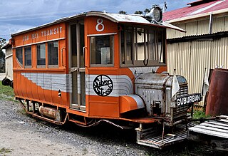
The Ida Bay Railway is a 7-kilometre (4.3 mi), 2 ft narrow gauge heritage railway. Located 105 kilometres (65 mi) south of Hobart, Tasmania, it is the most southerly railway in Australia.