The Australian Maritime College (AMC) is a tertiary education institution based in Launceston, Tasmania, established by the Maritime College Act 1978 (Cth). Tertiary education is provided and organised by the University of Tasmania (UTAS) as the Australian Maritime College (AMC) at the University of Tasmania (AMC@UTAS). However the college's educational curriculum is governed by the independent AMC Board. The AMC is Australia's national centre for maritime education, training and research. It has two campuses located within 50 kilometres (31 mi) of each other in Northern Tasmania, each with different facilities and residence.
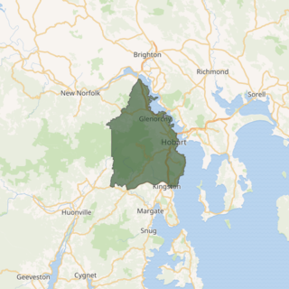
The electoral division of Denison was an electorate of the Tasmanian House of Assembly from 1909 to 2018. It was located in Hobart on the western shore of the River Derwent and includes the suburbs below Mount Wellington. Denison was named after Sir William Denison, who was Lieutenant Governor of Van Diemen's Land (1847–55), and Governor of New South Wales (1855–61). The electorate shared its name and boundaries with the federal division of Denison. The seat was abolished in September 2018 and replaced by the Division of Clark, in line with its federal namesake.

The electoral division of Lyons is one of the five electorates in the Tasmanian House of Assembly, it is the largest electorate covering most of central and eastern Tasmania. Lyons is named jointly in honor of Joseph Lyons, Prime Minister of Australia (1931–39); Premier of Tasmania (1923–1928), and Joseph's wife, Dame Enid Lyons, the first woman elected to the Australian House of Representatives in 1943. The electorate shares its name and boundaries with the federal division of Lyons.
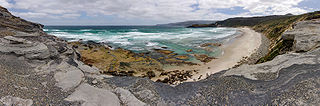
The South Coast Track is a bushwalking track located in the South Coast region of Tasmania, Australia. The 85-kilometre (53 mi) track traverses remote wilderness within the Southwest National Park, part of the Tasmanian Wilderness World Heritage Site, and is managed as a wilderness walk. The Tasmanian Parks & Wildlife Service recommend that experienced bushwalkers can take six-to-eight days to cover the track in one direction.
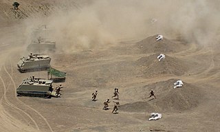
The Domain Athletic Centre is one of the premier athletics facilities in Tasmania, Australia, and is located on the Queens Domain in the capital city of Hobart. it is home to the Briggs Track Classic the Tasmanian round of the Australian Athletics Tour.
Ridgeway, Tasmania, a suburb of Hobart, is located south of Dynnyrne, and can be accessed by Waterworks Road and Ridgeway Road from Dynnyrne, or via Chimney Pot Hill Road from Fern Tree.
South Pasco Island is an island, with an area of 21 ha, in south-eastern Australia. It is part of Tasmania’s Pasco Island Group, lying in eastern Bass Strait off the north-west coast of Flinders Island in the Furneaux Group. It is used for grazing sheep.

Prime Seal Island is a long island, with a high central ridge and an area of 1220 ha, in south-eastern Australia. It is part of Tasmania’s Prime Seal Island Group, lying in eastern Bass Strait west of Flinders in the Furneaux Group. Geologically, it is limestone overlying granite and has notable karst features, including caves. It is leased for farming and is extensively grazed by sheep and cattle as well as the native Tasmanian pademelons.
Spectacle Island is an island, with an area of 3.5 ha, in south-eastern Australia. It is part of the Sloping Island Group, lying close to the south-eastern coast of Tasmania around the Tasman and Forestier Peninsulas.
Little Spectacle Island is a small island, with an area of 0.62 ha, part of the Sloping Island Group, lying close to the south-eastern coast of Tasmania, Australia around the Tasman and Forestier Peninsulas, and adjacent Spectacle Island.
Barren Island is a small island, with an area of 0.53 ha, in south-eastern Australia. It is part of the Sloping Island Group, lying close to the south-eastern coast of Tasmania around the Tasman and Forestier Peninsulas.

The Smooth Island, part of the Sloping Island Group, is a privately owned island with an area of 59.31 ha lying close to the south-eastern coast of Tasmania, Australia. The island is situated in Norfolk Bay, surrounded by the Tasman and Forestier Peninsulas. The towns Dunalley and Murdunna are nearby. Smooth Island differs from other Tasmanian islands as it has an unencumbered freehold title down to the high-water mark.
Visscher Island is an island, with an area of 3.4 ha, in south-eastern Tasmania, in Australia.

Buckland is a village on the Tasman Highway in Tasmania, Australia. It contains a historic church, St John the Baptist church. At the 2006 census, Buckland had a population of 193.
Grove is a suburb in the Huon Valley Council local government area in Tasmania, Australia. The suburb has a postcode of 7109.
Engineer Range is a mountain range in Western Tasmania, Australia.

The South-east Tasmania Important Bird Area encompasses much of the land retaining forest and woodland habitats, suitable for breeding swift parrots and forty-spotted pardalotes, from Orford to Recherche Bay in south-eastern Tasmania, Australia.
Andover is a village on the Little Swan River, in the county of Somerset, Tasmania about 50 miles from Hobart.

Lake Murchison is a man-made water reservoir located in the western region of Tasmania, Australia. The lake is situated within the northern part of Tasmania's West Coast Range and is fed by the Murchison River, the George Creek, the Anthony River, and discharge from the Tribute Power Station.
Coal River is a river in southern Tasmania. With headwaters near Tunnack, it flows through the Coal River Valley and the town of Richmond, and empties into Pitt Water. In Richmond, the river is crossed by the historically significant Richmond Bridge, the oldest bridge built in Australia that is still in use.