
Tasmania is an island state of Australia. It is located 240 km (150 mi) to the south of the Australian mainland, separated from it by the Bass Strait. The archipelago contains the southernmost point of the Australian federation. The state encompasses the main island of Tasmania, the 26th-largest island in the world, and the surrounding 1000 islands. It is Australia's least populated state, with 569,825 residents as of December 2021. The state capital and largest city is Hobart, with around 40 percent of the population living in the Greater Hobart area.
Van Diemen's Land was the colonial name of the island of Tasmania used by the British during the European exploration of Australia in the 19th century. A British settlement was established in Van Diemen's Land in 1803 before it became a separate colony in 1825. Its penal colonies became notorious destinations for the transportation of convicts due to the harsh environment, isolation and reputation for being inescapable. Macquarie Harbour and Port Arthur are among the most well-known penal settlements on the island.
Councils of Tasmania are the 29 administrative districts of the Australian state of Tasmania. Local government areas (LGAs), more generally known as councils, are the tier of government responsible for the management of local duties such as road maintenance, town planning and waste management.
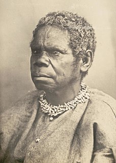
Truganini was an Aboriginal Tasmanian woman. She was one of the last native speakers of the Tasmanian languages and one of the last individuals solely of Aboriginal Tasmanian descent.
The history of Tasmania begins at the end of the most recent ice age when it is believed that the island was joined to the Australian mainland. Little is known of the human history of the island until the British colonisation in the 19th century.
Margate is a small seaside town on the Channel Highway between North-West Bay and the Snug Tiers, 7 kilometres (4 mi) south of Kingston in Tasmania, Australia. It is mostly in the Kingborough Council area, with about 4% in the Huon Valley Council LGA.

Bruny Island is a 362-square-kilometre (140 sq mi) island located off the south-eastern coast of Tasmania, Australia. The island is separated from the Tasmanian mainland by the D'Entrecasteaux Channel, and its east coast lies within the Tasman Sea. Storm Bay is located to the island's northeast. Both the island and the channel are named after French explorer, Antoine Bruni d'Entrecasteaux. Its traditional Aboriginal name is lunawanna-allonah, which survives as the name of two island settlements, Alonnah and Lunawanna.

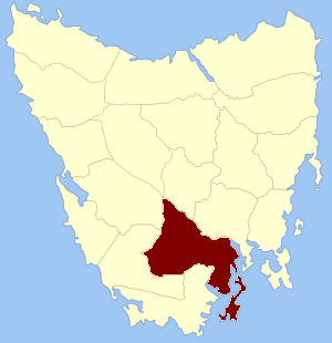
Huon Valley Council is a local government body in Tasmania, covering most of the south of the state. Huon Valley is classified as a rural local government area and has a population of 17,219, towns and localities of the region include Cygnet, Dover, Franklin, Geeveston, Southport and the largest principal town, Huonville.

George Town is a large town in north-east Tasmania, on the eastern bank of the mouth of the Tamar River. The Australian Bureau of Statistics records the George Town Municipal Area had a population of 6,764 as of 30 June 2016.

Antoine Raymond Joseph de Bruni, chevalier d'Entrecasteaux was a French naval officer, explorer and colonial governor. He is perhaps best known for his exploration of the Australian coast in 1792, while searching for the La Pérouse expedition. Antoine Bruni d'Entrecasteaux is commonly referred to simply as Bruni d'Entrecasteaux or Bruny d'Entrecasteaux, which is a compound surname.

The electoral division of Franklin is one of the five electorates in the Tasmanian House of Assembly, located in southern Tasmania and includes Bruny Island, Kingston and the eastern shore of the Derwent River. Franklin is named after Sir John Franklin, the Arctic explorer who was Lieutenant-Governor of Van Diemen's Land (1837–43). The division shares its name and boundaries with the federal division of Franklin.

George III was a British penal transportation convict ship launched in 1810 in London. She was shipwrecked with heavy loss of life when she was transporting convicts from England to the Australian Colonies. She was wrecked in the southern end of the D'Entrecasteaux Channel, Van Diemen's Land, with the loss of 134 of the 294 people on board.

The D'Entrecasteaux Channel is a body of water located between Bruny Island and the south-east of the mainland of Tasmania, Australia. The channel is the mouth for the estuaries of the Derwent and the Huon Rivers and empties into the Tasman Sea of the South Pacific Ocean. It was sighted by Abel Tasman in 1642 and surveyed in 1792 by Bruni d'Entrecasteaux.

The Huon Valley, or simply the Huon, is a valley and geographic area located in southern Tasmania, Australia. The largest town is Huonville, with other smaller towns spread across the area. It includes Australia's most southern permanent settlement at Southport. The Huon Valley Council area had a population of 15,140 in 2011. Famed for its apple growing, the Valley was first settled by British colonists in the 1820s; prior to settlement the Huon Valley area was inhabited by the Mouheneenner, Nuenonne, Mellukerdee and Lyluequonny people.
Cradoc is a rural residential locality in the local government area of Huon Valley in the South-east region of Tasmania. It is located about 11 kilometres (6.8 mi) south-west of the town of Huonville. The 2016 census has a population of 445 for the state suburb of Cradoc.
Buckingham Land District is one of the twenty land districts of Tasmania which are part of the Lands administrative divisions of Tasmania. It was formerly Buckingham County, one of the 18 counties of Tasmania and one of the first eleven proclaimed in 1836 and is bordered to the north by the River Derwent, and to the south by the Huon River. It includes Bruny Island. Hobart is located in the county. It was named after the then county of England.

Kettering is a coastal town on the D'Entrecasteaux Channel opposite Bruny Island, Tasmania, Australia. At the 2011 census, Kettering had a population of 984.

The Partridge Island, part of the Partridge Island Group, is an 103-hectare (250-acre) island that lies close to the south-eastern coast of Tasmania, Australia. The island is situated in the D'Entrecasteaux Channel, between Bruny Island and the mainland of Tasmania and is part of the South Bruny National Park.
Garden Island is a small stony island that is part of the Partridge Island Group, lying close to the south-eastern coast of Tasmania, Australia, in the D'Entrecasteaux Channel between Bruny Island and the mainland. The D'Entrecasteaux Channel is the mouth for the Huon River.
The Cygnet Folk Festival, run since 1982, is a three-day folk music festival held in Cygnet in Tasmania, Australia, that occurs annually on the second weekend in January.


