
Bass Strait is a strait separating the island state of Tasmania from the Australian mainland. The strait provides the most direct waterway between the Great Australian Bight and the Tasman Sea, and is also the only maritime route into the economically prominent Port Phillip Bay.

The Nullarbor Plain is part of the area of flat, almost treeless, arid or semi-arid country of southern Australia, located on the Great Australian Bight coast with the Great Victoria Desert to its north. It is the world's largest single exposure of limestone bedrock, and occupies an area of about 200,000 square kilometres (77,000 sq mi). At its widest point, it stretches about 1,100 kilometres (684 mi) from east to west across the border between South Australia and Western Australia.

The Great Australian Bight is a large oceanic bight, or open bay, off the central and western portions of the southern coastline of mainland Australia.

The Wilderness Society is an Australian, community-based, not-for-profit non-governmental environmental advocacy organisation. Its vision is to "transform Australia into a society that protects, respects and connects with the natural world that sustains us."

The South West Cape is a cape located at the south-west corner of Tasmania, Australia. The cape is situated in the south-western corner of the Southwest National Park, part of the Tasmanian Wilderness World Heritage Area, approximately 140 kilometres (87 mi) southwest of Hobart in Tasmania, and about 65 kilometres (40 mi) west and a little north of the South East Cape.

The West Coast of Tasmania is mainly isolated rough country, associated with wilderness, mining and tourism. It served as the location of an early convict settlement in the early history of Van Diemen's Land, and contrasts sharply with the more developed and populous northern and eastern parts of the island state.
The South East Cape is a cape located at the southernmost point of the main island of Tasmania, the southernmost state of Australia. The cape is situated in the southern and south-eastern corner of the Southwest National Park, part of the Tasmanian Wilderness World Heritage Area, approximately 94 kilometres (58 mi) southwest of Hobart in Tasmania and about 65 kilometres (40 mi) east and a little south of the South West Cape.
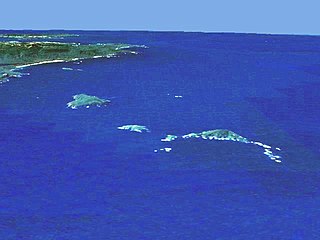
The Maatsuyker Islands are a group of islands and rocks located 5.5 kilometres (3.4 mi) off the south coast of Tasmania, Australia. Maatsuyker Island is the southernmost island of the group and of the Australian continental shelf. There are exposed rocks further south of Maatsuyker but they do not meet the definition of "islands". Macquarie Island, far to the south, is also Australian territory but it is an upthrust piece of ocean floor in the remote Southern Ocean and is in a geological sense completely separate from the continent.

Maatsuyker Island is an island located close to the south coast of Tasmania, Australia. The 186-hectare (0.72 sq mi) island is part of the Maatsuyker Islands Group, and comprises part of the Southwest National Park and the Tasmanian Wilderness World Heritage Site.

De Witt Island, also known as Big Witch, is an island located close to the south-western coast of Tasmania, Australia. The 516-hectare (1.99 sq mi) island is the largest of the Maatsuyker Islands Group, and comprises part of the Southwest National Park and the Tasmanian Wilderness World Heritage Site. The island is listed on the Australian Register of the National Estate.
Mount Darwin is a mountain located in the West Coast region of Tasmania, Australia.

The South West Wilderness of Tasmania, Australia is a remote and inaccessible region of South West Tasmania containing unspoilt scenery, rugged peaks, wild rivers, unique flora and fauna, and a long and rugged coastline. Parts of the wilderness are more than 50 km from the nearest road, so the only access to the area is by foot, air or sea.

Mewstone is an unpopulated island, composed of muscovite granite, located close to the south coast of Tasmania, Australia. The 13.1-hectare (32-acre) island has steep cliffs and a small flat summit and is part of the Pedra Branca group, lying 12 kilometres (7.5 mi) southeast of Maatsuyker Island, and 22 kilometres (14 mi) off the south coast of Tasmania. Mewstone comprises part of the Southwest National Park and the Tasmanian Wilderness World Heritage Site.
The Sidmouth Rock is a rock islet or small island, located in the Southern Ocean, off the southern coast of Tasmania, Australia. The island is situated approximately 28 kilometres (17 mi) south-east of South East Cape and is contained within the Southwest National Park, part of the Tasmanian Wilderness World Heritage Site. An erosional remnant of the Tasmanian mainland with a diameter of 90 metres (300 ft), the island is estimated to have separated from the Tasmanian mainland at least 15,000 years ago.

South West Tasmania is a region in Tasmania that has evoked curiosity as to its resources over the duration of European presence on the island.
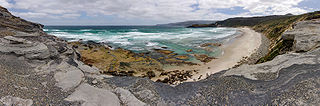
The South Coast Track is a bushwalking track located in the South Coast region of Tasmania, Australia. The 85-kilometre (53 mi) track traverses remote wilderness within the Southwest National Park, part of the Tasmanian Wilderness World Heritage Site, and is managed as a wilderness walk. The Tasmanian Parks & Wildlife Service recommend that experienced bushwalkers can take six-to-eight days to cover the track in one direction.
Port Davey is an oceanic inlet located in the south west region of Tasmania, Australia.
Engineer Range is a mountain range in Western Tasmania, Australia.
Karatta is a locality in the Australian state of South Australia located on the south coast of Kangaroo Island overlooking the body of water known in Australia as the Southern Ocean and by international authorities as the Great Australian Bight. Karatta is located about 191 kilometres south-west of the state capital of Adelaide.
Cox Bluff is the ocean end of the New Harbour Range, on the south coast of Tasmania. It is situated on the west side of Cox Bight, and east of New Harbour, located at the south-west corner of Tasmania, Australia.
