
Mount Ossa is the highest mountain in Tasmania, with a summit elevation of 1,617 metres (5,305 ft) above sea level. It makes up part of the Pelion Range within Cradle Mountain-Lake St Clair National Park in the Central Highlands region of Tasmania, Australia.
The Davey River is a perennial river located in the south-west region of Tasmania, Australia.

Mount Anne is a mountain located in the Southwest National Park in south-west region of Tasmania, Australia. The mountain lies within the UNESCO World Heritage-listed Tasmanian Wilderness.
Scotts Peak is a mountain in South West Tasmania which is associated with the construction and flooding of the original Lake Pedder, as the lake now completely surrounds the peak. It lies east of the Frankland Range and has an elevation of 669 metres.
The Scotts Peak Dam Road is the most southerly point of road access into the south western region of Tasmania, Australia.
The Serpentine Dam is a rockfill embankment dam with a concrete face and a controlled spillway across the Serpentine River, located in the South West region of Tasmania, Australia.

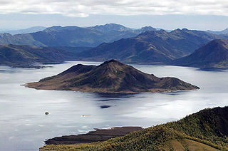
The Frankland Range is a mountain range that is located in the south-west region of Tasmania, Australia. The range forms part of a natural south-western border to the impounded Lake Pedder, formed by the damming of the Serpentine and Huon rivers.
Redtop Peak is a mountain in South West Tasmania. It lies on the North West end of the Frankland Range and the South West end of the Madonna Ridge above the impoundment Lake Pedder, to the west of The Cupola.
The Cupola is a mountain in the south-west region of Tasmania, Australia. Situated on the Frankland Range, The Cupola has an elevation of 970 metres (3,180 ft) above sea level and juts out from the range towards the impoundment Lake Pedder. The Redtop Peak is situated to the west of The Cupola.
The Lion is a mountain in South West Tasmania. It lies on the North West end of the Frankland Range jutting out toward the East from the range toward the impoundment Lake Pedder. It is the third-highest mountain in the Frankland Range. It is directly South of The Cupola and North of The Citadel.
The Citadel is a mountain in South West Tasmania. It lies on the north east end of the Frankland Range jutting out towards the east from the range towards the impoundment Lake Pedder. It is directly south of The Lion and west of Murpheys Bluff. It forms the south eastern border of The Moat, an alpine lake.
Murpheys Bluff is a mountain in South West Tasmania. It lies on the North West end of the Frankland Range jutting out toward the East from the range toward the impoundment Lake Pedder. It is directly East of The Citadel and North West of Cleft Peak. It towers above Bluff Tarn to the North West.
Cleft Peak is a mountain in South West Tasmania. It lies on the North West end of the Frankland Range jutting out toward the East from the range toward the impoundment Lake Pedder. It is South East of Murpheys Bluff and North West of Greycap.
Greycap is a mountain in South West Tasmania. It lies near the centre of the Frankland Range towards the impoundment Lake Pedder. It is south east of Cleft Peak and north west of Frankland Saddle. It is a wider than most of the other peaks on the Frankland Range, with less steep sloping sides.
Frankland Peak is a mountain in South West Tasmania. It lies on the southeastern end of the Frankland Range near the impoundment Lake Pedder. It is west of Secheron Peak and north of Right Angle Peak.
Mount Lloyd Jones is a mountain in South West Tasmania named after aviator and adventurer, Lloyd Lindsay Jones MBE (1916–2004). It lies on the South East end of the Frankland Range jutting out towards the east from the range towards the impoundment Lake Pedder. It is west of the end of the ridge line leading to the edge of Lake Pedder at Terminal Peak and North East of Secheron Peak.
Right Angle Peak is a mountain in South West Tasmania. It lies to the south east of the Frankland Range near the impoundment Lake Pedder. It is surrounded by small lakes such as Lake Surprise to the east. It is south west of Secheron Peak.
Terminal Peak is a mountain in South West Tasmania.
Mount Olympus is a mountain in the Cradle Mountain-Lake St Clair National Park in Tasmania, Australia. It is the 24th highest mountain in Tasmania at 1,472 metres (4,829 ft) above sea level and is situated about 8 kilometres (5.0 mi) South-East of Mount Gould and about 4 kilometres (2.5 mi) west of Lake St. Clair.
