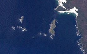
The Breaksea Islands Group is a group of six islands, in the Southern Ocean, off the southwestern coast of Tasmania, Australia.
Kathleen Island is a steeply cliffed island that lies within Port Davey, an oceanic inlet, located in the south west region of Tasmania, Australia. The island has an area of approximately 11.35 hectares and is contained with the Southwest National Park, part of the Tasmanian Wilderness World Heritage Site and the Port Davey/Bathurst Harbour Marine Nature Reserve.
The Shanks Islands form a group of five small rocky islets located close to the south-western coast of Tasmania, Australia. Situated near where the mouth of Port Davey meets the Southern Ocean, the islets have a combined area of 2.72 hectares and are part of the Swainson Islands Group. They comprise part of the Southwest National Park and the Tasmanian Wilderness World Heritage Site.

The Trumpeter Islets comprise a group of two unpopulated islets, with a combined area of about a hectare, located close to the south-western coast of Tasmania, Australia. Situated some 6 kilometres (3.7 mi) where the mouth of Port Davey meets the Southern Ocean, the 1-hectare (2.5-acre) island is part of the Trumpeter Islets Group, and comprises part of the Southwest National Park and the Tasmanian Wilderness World Heritage Site.

The Ile du Golfe is a limestone island located close to the south-western coast of Tasmania, Australia. The long, narrow dolphin-shaped 68-hectare (0.26 sq mi) island is part of the Maatsuyker Islands Group, and comprises part of the Southwest National Park and the Tasmanian Wilderness World Heritage Site.

Walker Island is an island located close to the south-western coast of Tasmania, Australia. The 15-hectare (0.058 sq mi) island is part of the Maatsuyker Islands Group, and comprise part of the Southwest National Park and the Tasmanian Wilderness World Heritage Site.

Flat Top Island is an island located close to the south-western coast of Tasmania, Australia. The 1.58-hectare (0.0061 sq mi) island is part of the Maatsuyker Islands Group, and comprises part of the Southwest National Park and the Tasmanian Wilderness World Heritage Site.
Round Top Island is an island located close to the south-western coast of Tasmania, Australia. The 6.25-hectare (0.0241 sq mi) island is part of the Maatsuyker Islands Group, and comprises part of the Southwest National Park and the Tasmanian Wilderness World Heritage Site.

The Wild Wind Islets comprise a group of five steep rocky unpopulated islets located close to the south-western coast of Tasmania, Australia. Situated some 2 kilometres (1.2 mi) south of where the mouth of Port Davey meets the Southern Ocean, the 3.95-hectare (9.8-acre) islets are one of the eight islands that comprise the Mutton Bird Islands Group. The Wild Wind Islets are part of the Southwest National Park and the Tasmanian Wilderness World Heritage Site.
South East Mutton Bird Islet is a steep unpopulated islet located close to the south-western coast of Tasmania, Australia. Situated 2 kilometres (1.2 mi) south of where the mouth of Port Davey meets the Southern Ocean, the 0.52-hectare (1.3-acre) islet is one of the eight islands that comprise the Mutton Bird Islands Group. The South East Mutton Bird Islet is part of the Southwest National Park and the Tasmanian Wilderness World Heritage Site.
South West Mutton Bird Islet is a dome-shaped unpopulated islet located close to the south-western coast of Tasmania, Australia. Situated some 2 kilometres (1.2 mi) south of where the mouth of Port Davey meets the Southern Ocean, the 0.52-hectare (1.3-acre) islet is one of the eight islands that comprise the Mutton Bird Islands Group. The South West Mutton Bird Islet is part of the Southwest National Park and the Tasmanian Wilderness World Heritage Site.
Sugarmouse Island is an unpopulated islet located close to the south-western coast of Tasmania, Australia. Situated some 2 kilometres (1.2 mi) south of where the mouth of Port Davey meets the Southern Ocean, the 0.54-hectare (1.3-acre) islet is one of the eight islands that comprise the Mutton Bird Islands Group. Sugarmouse Island is part of the Southwest National Park and the Tasmanian Wilderness World Heritage Site.
The East Pyramids comprise a group of three steep, rocky unpopulated islets located close to the south-western coast of Tasmania, Australia. Situated some 2 kilometres (1.2 mi) south of where the mouth of Port Davey meets the Southern Ocean, the 6.69-hectare (16.5-acre) islets are one of the eight islands that comprise the Mutton Bird Islands Group. The East Pyramids are part of the Southwest National Park and the Tasmanian Wilderness World Heritage Site.
Sugarloaf Rock is a steep, rocky unpopulated islet located close to the south-western coast of Tasmania, Australia. Situated some 2 kilometres (1.2 mi) south of where the mouth of Port Davey meets the Southern Ocean, the 3.56-hectare (8.8-acre) islet is one of the eight islands that comprise the Mutton Bird Islands Group. Sugarloaf Rock is part of the Southwest National Park and the Tasmanian Wilderness World Heritage Site.
Wendar Island comprises a main unpopulated island and five immediately adjacent islets located close to the south-western coast of Tasmania, Australia. Situated some 2 kilometres (1.2 mi) south of where the mouth of Port Davey meets the Southern Ocean, the 5.8-hectare (14-acre) island and islets are one of the eight islands that comprise the Mutton Bird Islands Group. The Mutton Bird Island is part of the Southwest National Park and the Tasmanian Wilderness World Heritage Site.
The Big Caroline Rock is an unpopulated island located close to the south-western coast of Tasmania, Australia. Situated near where the mouth of Port Davey meets the Southern Ocean, the 2.2-hectare (5.4-acre) island is part of the Swainson Islands Group, and comprises part of the Southwest National Park and the Tasmanian Wilderness World Heritage Site.
Swainson Island is an unpopulated island with an adjacent islet, located close to the south-western coast of Tasmania, Australia. Situated near where the mouth of Port Davey meets the Southern Ocean, the 4.14-hectare (10.2-acre) island is part of the Swainson Islands Group, and comprises part of the Southwest National Park and the Tasmanian Wilderness World Heritage Site.
The Fitzroy Islands comprise a group of four rocky islets that lie within the upper reaches of Payne Bay in Port Davey, an oceanic inlet, located in the south west region of Tasmania, Australia. The islands have a combined area of approximately 0.18 hectares and are contained with the Southwest National Park, part of the Tasmanian Wilderness World Heritage Site and the Port Davey/Bathurst Harbour Marine Nature Reserve.
West Pyramid is an unpopulated steep-sided island located close to the south-western coast of Tasmania, Australia. Situated some 1 kilometre (0.62 mi) north of the mouth of Port Davey where it meets the Southern Ocean, the 2.5-hectare (6.2-acre) island is part of the Trumpeter Islets Group, and comprises part of the Southwest National Park and the Tasmanian Wilderness World Heritage Site.
Hobbs Island, also known as Green Island, is an unpopulated island located close to the south-western coast of Tasmania, Australia. Situated some 1 kilometre (0.62 mi) north of where the mouth of Port Davey meets the Southern Ocean, the 9.7-hectare (24-acre) island is part of the Trumpeter Islets Group, and comprises part of the Southwest National Park and the Tasmanian Wilderness World Heritage Site.