South West Tasmania

Last updated

South West Tasmania
Tasmania
Mt Anne.jpg
Mount Anne is the tallest mountain in south-west Tasmania, at 1,423 m (4,669 ft) AMSL.
Population15
LGA(s)
State electorate(s) Lyons, Franklin
Federal division(s) Lyons, Franklin
Localities around South West Tasmania:
Southern Ocean North West Tasmania Central Highlands
Southern Ocean South West TasmaniaSouthern Tasmania
Southern Ocean Southern Ocean Southern Ocean

South West Tasmania is a region in Tasmania that has evoked curiosity as to its resources over the duration of European presence on the island.

Contents

The more recent is the consideration as a potential area of resources for development and its consideration as World Heritage wilderness.

The most notable controversies occurring in the region in the late twentieth century was the flooding of Lake Pedder and the proposed damming of the Franklin River by the Franklin Dam.

Southwest is a locality that covers most of the region. The locality (and therefore the region) is in the local government areas of Derwent Valley (29%), Huon Valley (20%), Central Highlands (7%) and West Coast (44%). Its central point, near the encircled locality of Strathgordon, is about 116 kilometres (72 mi) west of the town of New Norfolk, the administrative centre for the Derwent Valley Council. The 2016 census has a population of 15 for the state suburb of Southwest. [1]

Early surveys

Most early walks through the region were for discovery, or in the case of Thomas Bather Moore was to establish tracks for access.

In 1927, a walk through the area between Cox Bight and Bathurst Harbour even included the then governor of the state, Sir James O'Grady, and its intention was a search for geological information. [2]

Locality boundaries

The Southern Ocean forms the western and southern boundaries. The locality encircles Strathgordon, and is adjoined by the localities of Macquarie Heads, Strahan, West Coast, Queenstown, Gormanston, Lake St Clair, Derwent Bridge, Butlers Gorge, Tarraleah, Wayatinah, Florentine, Maydena, Styx, Lonnavale, Geeveston, Raminea, Strathblane, Hastings, Lune River, and Recherche. [3]

Road infrastructure

The A10 route (Lyell Highway) enters from Derwent Bridge in the north-east and runs generally north-west until it reaches the north-western boundary, where it exits to Queenstown. Route B61 (Gordon River Road) enters from Maydena in the east and runs generally west through Strathgordon to the Gordon Dam, where it ends. Route C607 (Scotts Peak Dam Road) starts at an intersection with B61 and runs south and west to Scotts Peak Dam, where it ends. [4] [5]

South West Advisory Committee

Members were Sir George B Cartland, G. J. Foot and A. G. Ogilvie. Submissions were received on its subject area. [6] [7] [8] It made a preliminary report in May 1976, [9] and a final report in August 1978. [10]

South West Tasmania Resources Survey

Following national and international concern over the fate of South West Tasmania, Commonwealth Government funded the survey with the States Grants (Nature Conservation Act) Act of 1974. Further funding was provided from the Environment (Financial Assistance) Act of 1977. [11]

The South West Tasmania Resources Survey produced 25 Discussion Papers, 22 Working Papers and 20 Occasional papers [12] - including the breakup of the region into river catchments: [13]

National inventory

Ten years after the South West Resources survey the Australia Heritage Commission published an inventory for the South West. [14]

See also

Related Research Articles

Southwest National Park National park in Tasmania, Australia

Southwest National Park is an Australian national park located in the south-west of Tasmania, bounded by the Franklin-Gordon Wild Rivers National Park to the north and the Hartz Mountains National Park to the east. It is a part of a chain of national parks and state reserves that make up the Tasmanian Wilderness World Heritage Area. Covering an area of 6,183 km2 (2,387 sq mi), it is Tasmania's largest national park.

Lake Pedder Lake in South West Tasmania, Australia

Lake Pedder, once a glacial outwash lake, is a man-made impoundment and diversion lake located in the southwest of Tasmania, Australia. In addition to its natural catchment from the Frankland Range, the lake is formed by the 1972 damming of the Serpentine and Huon rivers by the Hydro Electric Commission of Tasmania for the purposes of hydroelectric power generation.

Lake St Clair (Tasmania) Lake in Tasmania, Australia

Lake St Clair or leeawulenna is a natural freshwater lake located in the Central Highlands area of Tasmania, Australia. The lake forms the southern end of the Cradle Mountain-Lake St Clair National Park. It has an area of approximately 45 square kilometres (17 sq mi), and a maximum depth of 215 metres (705 ft), making it Australia's deepest lake.

Strathgordon is a rural locality in the local government area (LGA) of Derwent Valley in the South-east LGA region of Tasmania. The locality is about 121 kilometres (75 mi) west of the town of New Norfolk. The 2016 census provides a population of 15 for the state suburb of Southwest, which includes Strathgordon. It is on the road to the Gordon River dam the most south westerly road in the south west of Tasmania. It is a tourist destination for visitors wishing to visit the Southwest National Park and World Heritage listed wilderness.

Lyell Highway Highway in Western and Central Tasmania

The Lyell Highway is a highway in Tasmania, running from Hobart to Queenstown. It is the one of two transport routes that passes through the West Coast Range, the other being the Anthony Road.

West Coast Range Mountain range in Tasmania, Australia

The West Coast Range is a mountain range located in the West Coast region of Tasmania, Australia.

Central Plateau Conservation Area Protected area in Tasmania, Australia

Central Plateau Conservation Area is an animal and plant conservation area in Tasmania, Australia. It is adjacent to the Walls of Jerusalem National Park.

The Murchison River, part of the Pieman River catchment, is a major perennial river located in the West Coast region of Tasmania, Australia.

The Mackintosh River, part of the Pieman River catchment, is a major perennial river located in the West Coast region of Tasmania, Australia. The river was named in November 1828 by Henry Hellyer, a surveyor of the Van Diemans Land Company, in honour of Sir James Mackintosh, son of John Mackintosh of Kyllachy, Inverness-shire

Bathurst Harbour is a shallow bay located in the south west region of Tasmania, Australia. Bathurst Harbour is contained within the Port Davey/Bathurst Harbour Marine Nature Reserve, and the Southwest National Park, part of the Tasmanian Wilderness World Heritage Area.

Port Davey is an oceanic inlet located in the south west region of Tasmania, Australia.

Melaleuca, Tasmania Former settlement in Tasmania, Australia

Melaleuca is a remote locality in the south-west area of Tasmania, Australia.

Lake Mackintosh is a 17.5-kilometre-long (10.9 mi) reservoir with a surface area of 3,100-hectare (7,700-acre) that forms part of the Pieman power development running north–south past Mount Farrell, adjacent to the town of Tullah in Tasmania.
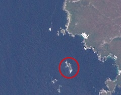
The Davey River is a perennial river located in the south-west region of Tasmania, Australia.

The Gordon River Road, sometimes called the Strathgordon Road, (B61), is a road in the south western region of Tasmania, Australia.

South Coast Tasmania Coastal area in Tasmania, Australia

South Coast Tasmania runs from the South East Cape to the South West Cape of Tasmania. South Coast Tasmania is sometimes conflated with the South West Tasmania wilderness region.

Engineer Range is a mountain range in Western Tasmania, Australia.

The Bathurst Channel is a narrow offshore stretch of water that links Port Davey with Bathurst Harbour in the South West region of Tasmania, Australia. The Bathurst Channel is contained within the Port Davey/Bathurst Harbour Marine Nature Reserve, and the Southwest National Park, part of the Tasmanian Wilderness World Heritage Area.

Pieman River Power Development was a major 1970s and 1980s hydroelectric development of the Pieman River and its tributaries on the west coast of Tasmania.

Helen Gee was an Australian author, editor, conservationist and environmental activist.

References

  1. "2016 Census Quick Stats Southwest (Tas.)". quickstats.censusdata.abs.gov.au. Australian Bureau of Statistics. 23 October 2017. Retrieved 20 July 2020.
  2. "VISIT TO SOUTH WEST TASMANIA". The Daily Telegraph . Launceston, Tas. 6 January 1927. p. 4. Retrieved 10 July 2015 via National Library of Australia.
  3. Google (20 July 2020). "Southwest, Tasmania" (Map). Google Maps . Google. Retrieved 20 July 2020.
  4. "Placenames Tasmania – Southwest". Placenames Tasmania. Select “Search”, enter "39388B", click “Search”, select row, map is displayed, click “Details”. Retrieved 20 July 2020.
  5. "Tasmanian Road Route Codes" (PDF). Department of Primary Industries, Parks, Water & Environment. May 2017. Archived from the original (PDF) on 1 August 2017. Retrieved 20 July 2020.
  6. Tasmanian Conservation Trust (1976), Saving Tasmania's south-west : an Australian wilderness heritage, Tasmanian Conservation Trust, retrieved 24 August 2014
  7. Australian Conservation Foundation; Tasmania. South West Advisory Committee (1976), Submission to the South West Advisory Committee on the South West National Park draft management plan, Australian Conservation Foundation, ISBN   978-0-85802-041-2
  8. Tasmania. National Parks and Wildlife Service (1976), Submission to the Special Advisory Committee on south-west Tasmania, National Parks and Wildlife, retrieved 24 August 2014
  9. Cartland, George; Foot, Geoffrey James; Ogilvie, Albert George; Tasmania. Parliament. South West Advisory Committee (1976), South West Advisory Committee preliminary report, May 1976 : to the Minister for National Parks and Wildlife, the Honourable N.L.C. Batt M.H.A., Parliament House, Tasmania, T.J. Hughes, Govt. Printer, retrieved 24 August 2014
  10. South West Advisory Committee report, August 1978 : to the Minister for National Parks and Wildlife, the Honourable A.B.K. Lohrey, M.H.A., Parliament House, Tasmania: presented by Sir George Barrington Cartland, Geoffrey James Foot [and] Albert George Ogilvie. Hobart: Government Printer. ISBN   0-7246-0550-9  : Tasmanian Parliamentary paper ; no.61 of 1978
  11. Waterman, Peter (editor) (1979) South West Tasmania Resources Survey Working Paper No.18 – Mackintosh-Murchison Catchment Sandy Bay, Tasmanian National Parks and Wildlife Service ISBN   0-7246-0261-5 – details of Survey p.1
  12. (1981) Nomination of Western Tasmania Wilderness National Parks by the Commonwealth of Australia for the Inclusion in the World Heritage List, prepared by Tasmanian Government and Australia Heritage Commission November 1981 ISBN   0-642-87820-X
  13. "Major catchments in South West Tasmania" – in Waterman, Peter (editor) (1979) South West Tasmania Resources Survey Working Paper No.18 Mackintosh-Murchison Catchment Sandy Bay, Tasmanian National Parks and Wildlife Service ISBN   0-7246-0261-5 – details of Survey p.201 – Map 7-1
  14. R.G. Lesslie, B.G. Mackey, J. Shulmeister (1988) National wilderness inventory : Stage II, wilderness quality in Tasmania Canberra : Australian Heritage Commission ISBN   0-642-13494-4 "A Report to the Australian Heritage Commission'.

Further reading