
The Great Dividing Range, also known as the East Australian Cordillera or the Eastern Highlands, is a cordillera system in eastern Australia consisting of an expansive collection of mountain ranges, plateaus and rolling hills, that runs roughly parallel to the east coast of Australia and forms the fifth-longest land-based mountain chain in the world, and the longest entirely within a single country. It is mainland Australia's most substantial topographic feature and serves as the definitive watershed for the river systems in eastern Australia, hence the name.
Highlands or uplands are any mountainous region or elevated mountainous plateau. Generally speaking, upland refers to ranges of hills, typically up to 500–600 m (1,600–2,000 ft). Highland is usually reserved for ranges of low mountains.

The West Coast Range is a mountain range located in the West Coast region of Tasmania, Australia.

Mount Owen is a mountain directly east of the town of Queenstown on the West Coast Range in Western Tasmania, Australia.

The Central Highlands is a region in Tasmania, Australia where geographical and administrative boundaries closely coincide. It is also known as The Lake Country of Tasmania.
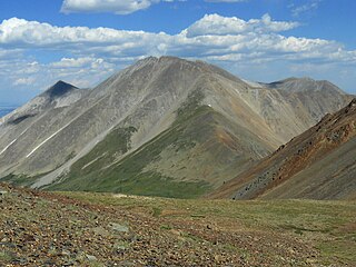
Tabeguache Peak is one of the fourteeners of the US state of Colorado. It is a near neighbor of the higher peak Mount Shavano, which lies approximately 1/2 mile to the southeast, and is close to being a subpeak of the latter. According to William Bright an American Linguist specialized in Native American and South Asian languages and descriptive linguistics it is pronounced "TAB-uh-wahch". According to Mountaineer Louis Dawson the name is pronounced "tab-uh-wash," with the accent on the first syllable. It lies just east of the Continental Divide and just west of the Arkansas River, in the south-central part of the Sawatch Range. It is located within the San Isabel National Forest and is in Chaffee County.
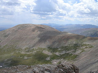
Mount Bross is a high mountain summit in the Mosquito Range of the Rocky Mountains of North America. The 14,178-foot (4,321 m) fourteener is located in Pike National Forest, 4.1 miles (6.6 km) northwest by north of the Town of Alma in Park County, Colorado, United States. Mount Bross is named in honor of William Bross, who owned property in the area.

The Arthur Range is a mountain range in the South West Wilderness, located in south-west Tasmania, Australia. The range is broken into two main sections, the Western Arthurs and the Eastern Arthurs. Both sections of the range are popular overnight bushwalking destinations, generally in summer.
The Eldon Range is a mountain range located in the west coast region of Tasmania, Australia.

The Legges Tor is the summit of the Ben Lomond mountain range in northeast Tasmania, Australia.

The New Guinea Highlands, also known as the Central Range or Central Cordillera, is a long chain of mountain ranges on the island of New Guinea, including the island's tallest peak, Puncak Jaya 16,024 ft (4,884 m), the highest mountain in Oceania. The range is home to many intermountain river valleys, many of which support thriving agricultural communities. The highlands run generally east-west the length of the island, which is divided politically between Indonesia in the west and Papua New Guinea in the east.

Mount Arthur is a mountain in the northern region of Tasmania, Australia. With an elevation of 1,188 metres (3,898 ft) above sea level, the mountain is located north-east of Launceston, near the town of Lilydale.

Quamby Bluff is a mountain in Northern Tasmania, Australia that is an outlying part of the Great Western Tiers mountain range.

Mount Geryon is a mountain in the Central Highlands region of the Australian state of Tasmania. The mountain is part of the Du Cane Range and is situated within the Cradle Mountain-Lake St Clair National Park.

Mount Anne is a mountain located in the Southwest National Park in south-west region of Tasmania, Australia. The mountain lies within the UNESCO World Heritage-listed Tasmanian Wilderness.
The Scotts Peak Dam is a rockfill embankment dam without a spillway across the Huon River, located in the South West region of Tasmania, Australia.

Mount King William I is a mountain adjacent to the Lyell Highway in Central Highlands, Tasmania. It is located 10 km southwest of Derwent Bridge. It is the northernmost of the King William Range.

Dry's Bluff is a mountain in the Great Western Tiers Range in Tasmania. The walk to its summit is listed in The Abels as one of the hardest day walks in Tasmania with an elevation gain of over 1000m from the base of the plateau. Access to the start of the walk is through Bob Brown's residence Oura Oura which has the sign Trespassers Welcome on the gate.
The Abels are a group of 158 Tasmanian mountains above 1100m and with a prominence of at least 150m. They are listed in the books The Abels and climbing them all is part of the Tasmanian peakbagging movement.
