Related Research Articles

Southwest National Park is an Australian national park located in the south-west of Tasmania, bounded by the Franklin-Gordon Wild Rivers National Park to the north and the Hartz Mountains National Park to the east. It is a part of a chain of national parks and state reserves that make up the Tasmanian Wilderness World Heritage Area. Covering an area of 6,183 km2 (2,387 sq mi), it is Tasmania's largest national park.

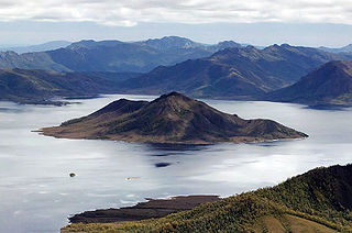
Lake Pedder, once a glacial outwash lake, is a man-made impoundment and diversion lake located in the southwest of Tasmania, Australia. In addition to its natural catchment from the Frankland Range, the lake is formed by the 1972 damming of the Serpentine and Huon rivers by the Hydro-Electric Commission for the purpose of hydroelectric power generation. Consequently, the lake is also known, somewhat derisively, as the Huon-Serpentine Impoundment.

The Gordon River is a major perennial river located in the central highlands, south-west, and western regions of Tasmania, Australia.

The Huon River is a perennial river located in the south-west and south-east regions of Tasmania, Australia. At 174 kilometres (108 mi) in length, the Huon River is the fifth-longest in the state, with its course flowing east through the fertile Huon Valley and emptying into the D'Entrecasteaux Channel, before flowing into the Tasman Sea.

The South West Wilderness of Tasmania, Australia is a remote and inaccessible region of South West Tasmania containing unspoilt scenery, rugged peaks, wild rivers, unique flora and fauna, and a long and rugged coastline. Parts of the wilderness are more than 50 km from the nearest road, so the only access to the area is by foot, air or sea.
The Gordon River Road, sometimes called the Strathgordon Road, (B61), is a road in the south western region of Tasmania, Australia.
The Serpentine River is a major perennial river located in the south-west and western regions of Tasmania, Australia.
Scotts Peak is a mountain in South West Tasmania which is associated with the construction and flooding of the original Lake Pedder, as the lake now completely surrounds the peak. It lies east of the Frankland Range and has an elevation of 669 metres.

The Frankland Range is a mountain range that is located in the south-west region of Tasmania, Australia. The range forms part of a natural south-western border to the impounded Lake Pedder, formed by the damming of the Serpentine and Huon rivers.
Redtop Peak is a mountain in South West Tasmania. It lies on the North West end of the Frankland Range and the South West end of the Madonna Ridge above the impoundment Lake Pedder, to the west of The Cupola.
The Cupola is a mountain in the south-west region of Tasmania, Australia. Situated on the Frankland Range, The Cupola has an elevation of 970 metres (3,180 ft) above sea level and juts out from the range towards the impoundment Lake Pedder. The Redtop Peak is situated to the west of The Cupola.
The Lion is a mountain in South West Tasmania. It lies on the North West end of the Frankland Range jutting out toward the East from the range toward the impoundment Lake Pedder. It is the third-highest mountain in the Frankland Range. It is directly South of The Cupola and North of The Citadel.
The Citadel is a mountain in South West Tasmania. It lies on the north east end of the Frankland Range jutting out towards the east from the range towards the impoundment Lake Pedder. It is directly south of The Lion and west of Murpheys Bluff. It forms the south eastern border of The Moat, an alpine lake.
Murpheys Bluff is a mountain in South West Tasmania. It lies on the North West end of the Frankland Range jutting out toward the East from the range toward the impoundment Lake Pedder. It is directly East of The Citadel and North West of Cleft Peak. It towers above Bluff Tarn to the North West.
Cleft Peak is a mountain in South West Tasmania. It lies on the North West end of the Frankland Range jutting out toward the East from the range toward the impoundment, Lake Pedder. It is South East of Murpheys Bluff and North West of Greycap.
Greycap is a mountain in South West Tasmania. It lies near the centre of the Frankland Range towards the impoundment Lake Pedder. It is south east of Cleft Peak and north west of Frankland Saddle. It is a wider than most of the other peaks on the Frankland Range, with less steep sloping sides.
Frankland Peak is a mountain in South West Tasmania. It lies on the southeastern end of the Frankland Range near the impoundment Lake Pedder. It is west of Secheron Peak and north of Right Angle Peak.
Mount Lloyd Jones is a mountain in South West Tasmania named after aviator and adventurer, Lloyd Lindsay Jones MBE (1916–2004). It lies on the South East end of the Frankland Range jutting out towards the east from the range towards the impoundment Lake Pedder. It is west of the end of the ridge line leading to the edge of Lake Pedder at Terminal Peak and North East of Secheron Peak.
Right Angle Peak is a mountain in South West Tasmania. It lies to the south east of the Frankland Range near the impoundment Lake Pedder. It is surrounded by small lakes such as Lake Surprise to the east. It is south west of Secheron Peak.
Secheron Peak is a mountain in South West Tasmania. It lies on the southeastern end of the Frankland Range near the impoundment Lake Pedder. It is east of Frankland Peak and towers over Lake Surprise to the north. Right Angle Peak lies one kilometre to the southwest.
References
- Solitary 4224, Edition 1 2001, Tasmania 1:25000 Series, Tasmap