Frankland Range

Last updated

Frankland Range
The Cupola.jpg
The Cupola, one of the peaks in the range.
Highest point
Peak Frankland Peak
Elevation 1,083 m (3,553 ft) [1]
AHD
Coordinates 42°58′48″S146°08′24″E / 42.98000°S 146.14000°E / -42.98000; 146.14000 [2]
Geography
Relief Map of Tasmania.png
Red triangle with thick white border.svg
Location of the Frankland Range in Tasmania
CountryAustralia
State Tasmania
Region South West
Range coordinates 42°59′S146°09′E / 42.983°S 146.150°E / -42.983; 146.150 Coordinates: 42°59′S146°09′E / 42.983°S 146.150°E / -42.983; 146.150

The Frankland Range is a mountain range that is located in the south-west region of Tasmania, Australia. The range forms part of a natural south-western border to the impounded Lake Pedder, formed by the damming of the Serpentine and Huon rivers.

Contents

As part of the South West Wilderness area, it is a less popular site of bushwalking than other, more famous, ranges in Tasmania's South West, and is for much more advanced walkers due to its length, isolation and terrain. Access routes to the range are by boat from the lake, or the roads at Strathgordon or Scotts Peak Dam. [3]

Nearby ranges include the Arthur, Companion, Folded, Tribulation, and the Wilmot ranges.

Notable peaks

RankNameHeightLocationNotes
1 Frankland Peak 1,083 metres (3,553 ft) 42°58′48″S146°08′24″E / 42.98000°S 146.14000°E / -42.98000; 146.14000 (Frankland Peak) [1] [2]
2 Secheron Peak 1,068 metres (3,504 ft) 42°59′14″S146°09′21″E / 42.98722°S 146.15583°E / -42.98722; 146.15583 (Secheron Peak)
3 The Lion 988 metres (3,241 ft) 42°56′52″S146°03′11″E / 42.94778°S 146.05306°E / -42.94778; 146.05306 (The Lion)
4 Mount Lloyd Jones 982 metres (3,222 ft) 42°58′48″S146°10′14″E / 42.98000°S 146.17056°E / -42.98000; 146.17056 (Mount Lloyd Jones)
5 The Cupola 970 metres (3,182 ft) 42°56′16″S146°03′04″E / 42.93778°S 146.05111°E / -42.93778; 146.05111 (The Cupola) [4]
6 Right Angle Peak 954 metres (3,130 ft) 42°59′40″S146°08′31″E / 42.99444°S 146.14194°E / -42.99444; 146.14194 (Right Angle Peak)
7 Cleft Peak 946 metres (3,104 ft) 42°57′45″S146°05′30″E / 42.96250°S 146.09167°E / -42.96250; 146.09167 (Cleft Peak)
8 Redtop Peak 935 metres (3,068 ft) 42°56′10″S146°02′20″E / 42.93611°S 146.03889°E / -42.93611; 146.03889 (Redtop Peak)
9 The Citadel 929 metres (3,048 ft) 42°57′20″S146°04′00″E / 42.95556°S 146.06667°E / -42.95556; 146.06667 (The Citadel)
10 Greycap 898 metres (2,946 ft) 42°58′16″S146°06′25″E / 42.97111°S 146.10694°E / -42.97111; 146.10694 (Greycap)
11 Murpheys Bluff 881 metres (2,890 ft) 42°57′16″S146°04′48″E / 42.95444°S 146.08000°E / -42.95444; 146.08000 (Murpheys Bluff)
12 Terminal Peak 785 metres (2,575 ft) 42°58′56″S146°11′59″E / 42.98222°S 146.19972°E / -42.98222; 146.19972 (Terminal Peak)

See also

Related Research Articles

<span class="mw-page-title-main">West Coast Range</span> Mountain range in Tasmania, Australia

The West Coast Range is a mountain range located in the West Coast region of Tasmania, Australia.

<span class="mw-page-title-main">Mount Owen (Tasmania)</span> Mountain in Tasmania, Australia

Mount Owen is a mountain directly east of the town of Queenstown on the West Coast Range in Western Tasmania, Australia.

<span class="mw-page-title-main">Mount Huxley (Tasmania)</span> Mountain in Tasmania, Australia

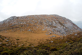
Mount Huxley is a mountain located on the West Coast Range in the West Coast region of Tasmania, Australia. With an elevation of 926 metres (3,038 ft) above sea level, the mountain was named by Charles Gould in 1863 in honour of Professor Thomas Henry Huxley.

Mount Darwin is a mountain located in the West Coast region of Tasmania, Australia.

Mount Jukes is a mountain located on the Jukes Range, a spur off the West Coast Range, in the West Coast region of Tasmania, Australia.

<span class="mw-page-title-main">Mount Sedgwick (Tasmania)</span> Mountain in Tasmania, Australia

Mount Sedgwick is a mountain located within the West Coast Range, in the West Coast region of Tasmania, Australia.

Mount Tyndall is a mountain that is part of the Tyndall Range, a spur off the West Coast Range, located in the Western region of Tasmania, Australia.

Mount Geikie is a mountain in the West Coast Range of Western Tasmania, Australia.

The Sticht Range is a mountain range located in the West Coast region of Tasmania, Australia. The range runs between two tributaries of the Eldon River and is located within the eastern part of the West Coast Range and has an unnamed peak with an elevation of 1,080 metres (3,540 ft) above sea level.

The Eldon Range is a mountain range located in the west coast region of Tasmania, Australia.

<span class="mw-page-title-main">Wellington Range</span> Mountain range in Tasmania, Australia

The Wellington Range is a mountain range located in the southeast region of Tasmania, Australia. The range is mainly composed of dolerite and features evidence of past glaciation.

<span class="mw-page-title-main">Ironstone Mountain</span> Mountain in Tasmania, Australia

The Ironstone Mountain is a mountain located in the Central Highlands region of Tasmania, Australia. Part of Great Western Tiers escarpment, the mountain is situated south of the small country village of Mole Creek.

<span class="mw-page-title-main">Du Cane Range</span>

The Du Cane Range is a mountain range in the Central Highlands region of Tasmania, Australia.

<span class="mw-page-title-main">Mount Geryon</span> Mountain in Tasmania, Australia

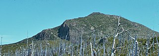
Mount Geryon is a mountain in the Central Highlands region of the Australian state of Tasmania. The mountain is part of the Du Cane Range and is situated within the Cradle Mountain-Lake St Clair National Park.

Mount Achilles is a mountain that is part of the Du Cane Range, located in the Cradle Mountain-Lake St Clair National Park in Tasmania, Australia. With an elevation of 1,353 metres (4,439 ft) above sea level, the peak is the 46th highest mountain in Tasmania.

The Serpentine Dam is a rockfill embankment dam with a concrete face and a controlled spillway across the Serpentine River, located in the South West region of Tasmania, Australia.

<span class="mw-page-title-main">The Cupola (mountain)</span> Mountain in Tasmania, Australia

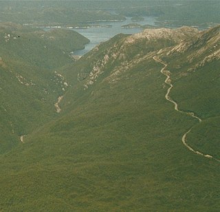
The Cupola is a mountain in the south-west region of Tasmania, Australia. Situated on the Frankland Range, The Cupola has an elevation of 970 metres (3,180 ft) above sea level and juts out from the range towards the impoundment Lake Pedder. The Redtop Peak is situated to the west of The Cupola.

<span class="mw-page-title-main">Tyndall Range</span> Mountains in Western Tasmania, Australia

The Tyndall Range, commonly called The Tyndalls, is a mountain range that is part of the West Coast Range located in the Western region of Tasmania, Australia.

References

  1. 1 2 Solitary (Map) (1st ed.). 1:25000. Tasmania: Tasmap. 2001.
  2. 1 2 "Frankland Peak (TAS)". Gazetteer of Australia online. Geoscience Australia, Australian Government.
  3. Chapman, John. South West Tasmania (4th ed.). pp. 173–175.
  4. "The Cupola (TAS)". Gazetteer of Australia online. Geoscience Australia, Australian Government.