Deal Island (Tasmania)

Last updated

Deal Island
Kent Group map.png
Deal Island is the largest of the Kent Group.
Relief Map of Tasmania.png
Red pog.svg
Deal Island
Location of Deal Island in Bass Strait
Geography
Location Bass Strait
Coordinates 39°28′12″S147°19′12″E / 39.47000°S 147.32000°E / -39.47000; 147.32000
Archipelago Kent Group
Area1,576 ha (3,890 acres) [1]
Administration
State Tasmania

Deal Island, the largest island of the Kent Group, is a 1,576-hectare (3,890-acre) granite island, located in northern Bass Strait, that lies between the Furneaux Group, north-east of Tasmania, and Wilsons Promontory, in Victoria, Australia. [2]

Contents

Location and features

The island is contained entirely within the 2,374-hectare (5,870-acre) Kent Group National Park, Tasmania’s northernmost national park, gazetted in 2002. [1] In 2004, the national park was extended to include the marine waters of the three major islands of the Kent Group, encapsulating 29,000 hectares (72,000 acres) of marine reserve. [3]

Deal Island is at the southern end of the 292,800-hectare (724,000-acre) Beagle Commonwealth Marine Reserve, that encloses the Kent Group Marine Reserve and the Hogan and Curtis Island groups. [4]

Deal Island has been extensively modified by human activity, with the construction of facilities, and the clearing of vegetation and regular firing associated with grazing livestock. There is a lighthouse, a closed airstrip, roads, jetty, two houses, a dam and a museum. [5]

Lighthouse

Deal Island Lighthouse Deal Island.jpg
Deal Island Lighthouse

Deal Island has the highest lighthouse in the Southern Hemisphere, [6] standing 305 metres (1,001 ft) above sea level. The light was sometimes visible at night from Wilson's Promontory, 80 kilometres (50 mi) away.[ citation needed ] The lighthouse was built in 1848 and deactivated in 1992. While active, the height of the tower caused problems with visibility in low cloud conditions. Management and conservation of the structure is under the control of the Tasmania Parks and Wildlife Service. [6]

Aircraft crash

On 26 April 1943, during World War II, an RAAF Airspeed Oxford aircraft crashed on the island, killing all four crewmen. The aircraft wreck, and the crew's graves, are about 15 metres (49 ft) apart at the bottom of a cliff. The bodies have since been disinterred and buried at Springvale, Victoria. [7] Eyewitness accounts say the plane flew low over a ship which was actually a wreck, and then failed to regain enough height before hitting the cliff.

Fauna

Seabird and wader species that have been recorded breeding on the island include the little penguin, the Pacific gull and the sooty oystercatcher. Mammals found on the island include the red-necked wallaby, the common brushtail possum, the southern brown bandicoot, the fur seal, and the introduced European rabbit. Reptiles include the metallic skink, Bougainville's skink, White's skink and the white-lipped snake. [5]

Climate

Deal Island has a borderline Mediterranean (Csb)/oceanic climate (Cfb) with mild, short, somewhat dry summers and cool, wet winters, owing to its exposed location.

Climate data for Deal Island (1871-present)
MonthJanFebMarAprMayJunJulAugSepOctNovDecYear
Record high °C (°F)35.8
(96.4)
32.8
(91.0)
31.3
(88.3)
25.5
(77.9)
23.2
(73.8)
18.2
(64.8)
17.2
(63.0)
20.4
(68.7)
24.9
(76.8)
26.0
(78.8)
33.6
(92.5)
30.2
(86.4)
35.8
(96.4)
Mean daily maximum °C (°F)20.2
(68.4)
20.5
(68.9)
19.4
(66.9)
17.6
(63.7)
15.6
(60.1)
13.5
(56.3)
12.7
(54.9)
12.8
(55.0)
13.7
(56.7)
15.4
(59.7)
16.8
(62.2)
18.3
(64.9)
16.4
(61.5)
Mean daily minimum °C (°F)14.1
(57.4)
14.6
(58.3)
14.2
(57.6)
12.8
(55.0)
11.5
(52.7)
9.7
(49.5)
8.5
(47.3)
8.2
(46.8)
8.9
(48.0)
9.8
(49.6)
11.2
(52.2)
12.6
(54.7)
11.3
(52.3)
Record low °C (°F)4.9
(40.8)
8.0
(46.4)
3.8
(38.8)
3.3
(37.9)
0.4
(32.7)
−0.5
(31.1)
−0.5
(31.1)
−5.5
(22.1)
−0.2
(31.6)
5.0
(41.0)
−4.0
(24.8)
2.5
(36.5)
−5.5
(22.1)
Average precipitation mm (inches)40.7
(1.60)
38.7
(1.52)
52.3
(2.06)
61.1
(2.41)
73.6
(2.90)
78.5
(3.09)
78.5
(3.09)
73.3
(2.89)
61.4
(2.42)
60.8
(2.39)
50.8
(2.00)
49.6
(1.95)
718.8
(28.30)
Average precipitation days (≥ 0.2 mm)8.27.49.712.414.816.016.916.414.513.311.510.0151.1
Source: Bureau of Meteorology [8]

See also

Related Research Articles

<span class="mw-page-title-main">Maatsuyker Island</span> Island in Tasmania, Australia

Maatsuyker Island is an island located close to the south coast of Tasmania, Australia. The 186-hectare (0.72 sq mi) island is part of the Maatsuyker Islands Group, and comprises part of the Southwest National Park and the Tasmanian Wilderness World Heritage Site.

<span class="mw-page-title-main">Waterhouse Island (Tasmania)</span> Island in Tasmania, Australia

Waterhouse Island, part of the Waterhouse Island Group, is a 287-hectare (710-acre) granite island situated in Banks Strait, part of Bass Strait, lying close to the north-eastern coast of Tasmania, Australia.

<span class="mw-page-title-main">Breaksea Islands (Tasmania)</span> Island group in Tasmania, Australia

The Breaksea Islands Group is a group of six islands, in the Southern Ocean, off the southwestern coast of Tasmania, Australia.

Kathleen Island is a steeply cliffed island that lies within Port Davey, an oceanic inlet, located in the south west region of Tasmania, Australia. The island has an area of approximately 11.35 hectares and is contained with the Southwest National Park, part of the Tasmanian Wilderness World Heritage Site and the Port Davey/Bathurst Harbour Marine Nature Reserve.

<span class="mw-page-title-main">Schouten Island</span> Island off eastern Tasmania

Schouten Island, part of the Schouten Island Group, is an island with an area of approximately 28 square kilometres (11 sq mi) lying close to the eastern coast of Tasmania, Australia, located 1.6 kilometres (0.99 mi) south of the Freycinet Peninsula and is a part of Freycinet National Park. The palawa kani place name for the island is mayaluwarana.

The Goose Island, part of the Badger Group within the Furneaux Group, is a 109-hectare (270-acre) unpopulated elongated granite island, located in Bass Strait, lying west of the Flinders and Cape Barren islands, Tasmania, south of Victoria, in south-eastern Australia.

<span class="mw-page-title-main">Rodondo Island</span> Island in Tasmania, Australia

Rodondo Island is a granite island, part of the Rodondo Group, lying in northern Bass Strait, within the state boundaries of Tasmania, Australia. The island is located only 10 kilometres (6.2 mi) south of Wilsons Promontory in Victoria, and 2' of latitude south of the Victoria-Tasmania border at latitude 39°12'S. Rodondo Island is ringed by steep cliffs up to 200 metres (660 ft) high, with an area of 106 hectares and a maximum elevation of 350 metres (1,150 ft) above sea level.

<span class="mw-page-title-main">Judgement Rocks</span> Island in Tasmania, Australia

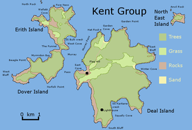
The Judgement Rocks, part of the Kent Group, is a small unpopulated 0.39-hectare (0.96-acre) granite islet and some associated bare rocks, located in the Bass Strait, lying off the north-east coast of Tasmania, between the Furneaux Group and Wilsons Promontory in Victoria, Australia. The islet and associated rocks are contained within the Kent Group National Park.

<span class="mw-page-title-main">Dover Island (Tasmania)</span> Island in Tasmania, Australia

Dover Island, the third largest island in the Kent Group, is a densely vegetated and unpopulated 295-hectare (730-acre) granite island with steep slopes, located in the Bass Strait, lying off the north-east coast of Tasmania, between the Furneaux Group and Wilsons Promontory in Victoria, Australia.

<span class="mw-page-title-main">Erith Island</span> Island in Tasmania, Australia

Erith Island, the second largest island in the Kent Group, is a densely vegetated and unpopulated 323-hectare (800-acre) granite island with steep slopes, located in the Bass Strait, lying off the north-east coast of Tasmania, between the Furneaux Group and Wilsons Promontory in Victoria, Australia.

<span class="mw-page-title-main">North East Isle</span> Island in Tasmania, Australia

The North East Isle, part of the Kent Group, is an unpopulated 32.62-hectare (80.6-acre) granite island, located in the Bass Strait, lying off the north-east coast of Tasmania, between the Furneaux Group and Wilsons Promontory in Victoria, Australia.

<span class="mw-page-title-main">South West Isle (Tasmania)</span> Island in Tasmania, Australia

The South West Isle, part of the Kent Group, is an unpopulated 19.09-hectare (47.2-acre) granite island, located in the Bass Strait, lying off the north-east coast of Tasmania, between the Furneaux Group and Wilsons Promontory in Victoria, Australia.

<span class="mw-page-title-main">Passage Island (Tasmania)</span> Island in Tasmania, Australia

The Passage Island, part of the Passage Group within the Furneaux Group, is a 253-hectare (630-acre) granite and dolerite island, located in Bass Strait south of Cape Barren Island, in Tasmania, in south-eastern Australia.

Badger Island, part of the Badger Group within the Furneaux Group, is a 1,242-hectare (3,070-acre) unpopulated low-lying granite and limestone island, located in Bass Strait, lying west of the Flinders and Cape Barren islands, Tasmania, south of Victoria, in south-eastern Australia.

<span class="mw-page-title-main">Great Dog Island (Tasmania)</span> Island in Tasmania, Australia

The Great Dog Island, also known as Big Dog Island, and part of the Great Dog Group within the Furneaux Group, is a 354-hectare (870-acre) granite island, located in Bass Strait, lying south of the Flinders Island and north of the Cape Barren Island, in Tasmania, in south-eastern Australia.

<span class="mw-page-title-main">Vansittart Island</span> Island in Tasmania, Australia

Vansittart Island, also known as Gun Carriage Island, is a granite island with an area of 800 hectares. The island is part of Tasmania's Vansittart Island Group, lying in eastern Bass Strait between Flinders and Cape Barren Islands in the Furneaux Group.

<span class="mw-page-title-main">Babel Island</span> Island in Tasmania, Australia

The Babel Island, part of the Babel Group within the Furneaux Group, is a 440-hectare (1,100-acre) granite island, located in Bass Strait, lying off the east coast of Flinders Island, Tasmania, south of Victoria, Australia. The privately owned island was named by Matthew Flinders from the noises made by the seabirds there.

<span class="mw-page-title-main">Swan Island (Tasmania)</span> Island in Bass Strait, Tasmania

Swan Island, part of the Waterhouse Island Group, is a 239-hectare (590-acre) granite island situated in Banks Strait, part of Bass Strait, lying close to the north-eastern coast of Tasmania, Australia.

<span class="mw-page-title-main">Actaeon Island</span> Island in Tasmania, Australia

The Actaeon Island, part of the Actaeon Island Group, is a 15.65-hectare (38.7-acre) dolerite island and game reserve located at the southern entrance to the D'Entrecasteaux Channel between Bruny Island and the mainland, that lies close to the south-eastern coast of Tasmania, Australia. The island is named for the ship Actaeon, which wrecked there in 1822.

The Fitzroy Islands comprise a group of four rocky islets that lie within the upper reaches of Payne Bay in Port Davey, an oceanic inlet, located in the south west region of Tasmania, Australia. The islands have a combined area of approximately 0.18 hectares and are contained with the Southwest National Park, part of the Tasmanian Wilderness World Heritage Site and the Port Davey/Bathurst Harbour Marine Nature Reserve.

References

  1. 1 2 "Kent Group National Park". Parks & Wildlife Service, Department of Primary Industries, Parks, Water and Environment. Tasmanian Government. 14 October 2010. Archived from the original on 26 March 2016. Retrieved 3 July 2016.
  2. "Deal Island (TAS)". Gazetteer of Australia online. Geoscience Australia, Australian Government.
  3. "Kent Group Marine Reserve". Parks & Wildlife Service, Department of Primary Industries, Parks, Water and Environment. Tasmanian Government. 19 June 2014. Archived from the original on 21 July 2008. Retrieved 3 July 2016.
  4. "Beagle Commonwealth Marine Reserve". Marine reserves. Department of the Environment, Australian Government. Retrieved 4 July 2016.
  5. 1 2 Brothers, Nigel; Pemberton, David; Pryor, Helen; & Halley, Vanessa. (2001). Tasmania’s Offshore Islands: seabirds and other natural features. Tasmanian Museum and Art Gallery: Hobart. ISBN   0-7246-4816-X
  6. 1 2 "Deal Island lighthouse". Lighthouses of Tasmania. Lighthouses of Australia Inc.
  7. "Picking up the wrecked pieces". The Age Online. Fairfax Media. May 2005. Retrieved 11 April 2015.
  8. "Climate Statistics for Deal Island". Climate statistics for Australian locations. Bureau of Meteorology. Retrieved 23 October 2012.