De Witt Island, also known as Big Witch, is an island located close to the south-western coast of Tasmania, Australia. The 516-hectare (1.99 sq mi) island is the largest of the Maatsuyker Islands Group, and comprises part of the Southwest National Park and the Tasmanian Wilderness World Heritage Site. The island is listed on the Australian Register of the National Estate.

The Trumpeter Islets comprise a group of two unpopulated islets, with a combined area of about a hectare, located close to the south-western coast of Tasmania, Australia. Situated some 6 kilometres (3.7 mi) where the mouth of Port Davey meets the Southern Ocean, the 1-hectare (2.5-acre) island is part of the Trumpeter Islets Group, and comprises part of the Southwest National Park and the Tasmanian Wilderness World Heritage Site.
The Goose Island, part of the Badger Group within the Furneaux Group, is a 109-hectare (270-acre) unpopulated elongated granite island, located in Bass Strait, lying west of the Flinders and Cape Barren islands, Tasmania, south of Victoria, in south-eastern Australia.
The Long Island, part of the Long Island Group within the Furneaux Group, is a 313-hectare (770-acre) unpopulated granite and dolerite island, located in Bass Strait, lying north-west of the Cape Barren Island in Tasmania, in south-eastern Australia. The island is part of the Franklin Sound Islands Important Bird Area, identified as such by BirdLife International because it holds over 1% of the world populations of six bird species.
The Oyster Rocks are a close pair of small granite islands, with a combined area of about 6 ha, in south-eastern Australia. They are part of Tasmania’s Tin Kettle Island Group, lying in eastern Bass Strait between Flinders and Cape Barren Islands in the Furneaux Group. They are a conservation area. The islands are part of the Franklin Sound Islands Important Bird Area, identified as such by BirdLife International because it holds over 1% of the world populations of six bird species.
The Albatross Island, part of the Hunter Island Group, is an 18-hectare (44-acre) island and nature reserve located in Bass Strait, that lies between north-west Tasmania and King Island, Australia. The Peerapper name for the island is Tangatema.

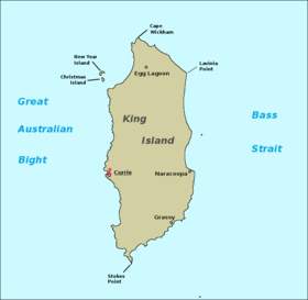
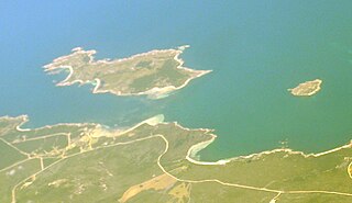
Christmas Island, part of the New Year Group, is a 63.49-hectare (156.9-acre) granite island located in the Great Australian Bight, lying off the north-west coast of Tasmania, Australia.
Councillor Island, part of the New Year Group, is a 10.53-hectare (26.0-acre) granite island located in the Bass Strait, lying off the north-west coast of Tasmania, Australia.
West Moncoeur Island is a granite island, ringed by steep cliffs, with an area of 9.18 ha, in south-eastern Australia. It is part of Tasmania’s Rodondo Group, lying in northern Bass Strait south of Wilsons Promontory in Victoria. It is a nature reserve.
East Moncoeur Island is a granite island, with an area of 14 ha.

The Passage Island, part of the Passage Group within the Furneaux Group, is a 253-hectare (630-acre) granite and dolerite island, located in Bass Strait south of Cape Barren Island, in Tasmania, in south-eastern Australia.
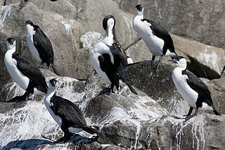
Boxen Island is a flat dolerite island, with an area of 7 ha, in south-eastern Australia. It is part of Tasmania’s Long Island Group, lying in eastern Bass Strait west of Cape Barren Island in the Furneaux Group. Together with nearby Big Black Reef it is classified by BirdLife International as an Important Bird Area because it has been recorded as supporting 288 breeding pairs of black-faced cormorants.

Pelican Island is an island, with an area of 6.8 ha including an associated reef joined to it at low tide, in south-eastern Australia. It is part of Tasmania’s Vansittart Island Group, lying in eastern Bass Strait between Flinders and Cape Barren Islands in the Furneaux Group. Until 1984 it was leased for grazing. The island is part of the Franklin Sound Islands Important Bird Area, identified as such by BirdLife International because it holds over 1% of the world populations of six bird species.

The St Helens Island, part of the Waterhouse Island Group, is a 51-hectare (130-acre) granite island situated in the Tasman Sea, lying close to the north-eastern coast of Tasmania, Australia.

The Ile du Golfe is a limestone island located close to the south-western coast of Tasmania, Australia. The long, narrow dolphin-shaped 68-hectare (0.26 sq mi) island is part of the Maatsuyker Islands Group, and comprises part of the Southwest National Park and the Tasmanian Wilderness World Heritage Site.

Flat Witch Island, also known as Little Witch Island, is an island located close to the south-western coast of Tasmania, Australia. The 64-hectare (0.25 sq mi) island is part of the Maatsuyker Islands Group, and comprises part of the Southwest National Park and the Tasmanian Wilderness World Heritage Site.

Walker Island is an island located close to the south-western coast of Tasmania, Australia. The 15-hectare (0.058 sq mi) island is part of the Maatsuyker Islands Group, and comprise part of the Southwest National Park and the Tasmanian Wilderness World Heritage Site.
Round Top Island is an island located close to the south-western coast of Tasmania, Australia. The 6.25-hectare (0.0241 sq mi) island is part of the Maatsuyker Islands Group, and comprises part of the Southwest National Park and the Tasmanian Wilderness World Heritage Site.

Mutton Bird Island is an irregularly shaped unpopulated island located close to the south-western coast of Tasmania, Australia. Situated some 2 kilometres (1.2 mi) south of where the mouth of Port Davey meets the Southern Ocean, the 44-hectare (110-acre) is the largest of the eight islands that comprise the Mutton Bird Islands Group. The Mutton Bird Island is part of the Southwest National Park and the Tasmanian Wilderness World Heritage Site.
West Pyramid is an unpopulated steep-sided island located close to the south-western coast of Tasmania, Australia. Situated some 1 kilometre (0.62 mi) north of the mouth of Port Davey where it meets the Southern Ocean, the 2.5-hectare (6.2-acre) island is part of the Trumpeter Islets Group, and comprises part of the Southwest National Park and the Tasmanian Wilderness World Heritage Site.