The Sloping Island Group is a group of small islands in south-eastern Tasmania in Australia. They lie close to the south-eastern coast of Tasmania around the Tasman and Forestier Peninsulas. [1]
The group consists of: [2]
The Sloping Island Group is a group of small islands in south-eastern Tasmania in Australia. They lie close to the south-eastern coast of Tasmania around the Tasman and Forestier Peninsulas. [1]
The group consists of: [2]
Huon Island is an island with an area of 47 hectares in south-eastern Australia. It is part of the Partridge Island Group, lying close to the south-eastern coast of Tasmania, in the D'Entrecasteaux Channel between Bruny Island and the mainland. The island has a small human population and has been subjected to intensive agricultural activities in the past. The Nuenonne name of the island is Prahree.

East Island is a granite island, with an area of 12.42 ha, in south-eastern Australia. It is part of Tasmania’s Hogan Group, lying in northern Bass Strait between the Furneaux Group and Wilsons Promontory in Victoria.
Roydon Island is an island, with an area of 37 ha, in south-eastern Australia. It is part of Tasmania’s Pasco Island Group, lying in eastern Bass Strait off the north-west coast of Flinders Island in the Furneaux Group.
The Middle Pasco Islands comprise two similarly sized adjacent granite islands, with a combined area of 8.37 ha, in south-eastern Australia. They form part of Tasmania’s Pasco Island Group, lying in eastern Bass Strait off the north-west coast of Flinders Island in the Furneaux Group.
South Pasco Island is an island, with an area of 21 ha, in south-eastern Australia. It is part of Tasmania’s Pasco Island Group, lying in eastern Bass Strait off the north-west coast of Flinders Island in the Furneaux Group. It is used for grazing sheep.
Marriott Reef is a small group of granite islets, with a combined area of 3.4 ha, in south-eastern Australia. It forms part of Tasmania’s Pasco Island Group, lying in eastern Bass Strait off the north-west coast of Flinders Island in the Furneaux Group.

Prime Seal Island is a long island, with a high central ridge and an area of 1220 ha, in south-eastern Australia. It is part of Tasmania’s Prime Seal Island Group, lying in eastern Bass Strait west of Flinders in the Furneaux Group. Geologically, it is limestone overlying granite and has notable karst features, including caves. It is leased for farming and is extensively grazed by sheep and cattle as well as the native Tasmanian pademelons.
Bird Island is a small granite island with an area of 1.5 ha, in south-eastern Australia. It is part of Tasmania’s Prime Seal Island Group, lying in eastern Bass Strait west of Flinders in the Furneaux Group. It is joined to Flinders Island at low tide.
Spectacle Island is a 3.5-hectare (8.6-acre) island in south-eastern Australia. It is part of the Sloping Island Group, lying close to the south-eastern coast of Tasmania around the Tasman and Forestier Peninsulas. Recorded breeding seabird and wader species are little penguin, short-tailed shearwater and pied oystercatcher.
Little Spectacle Island is a small island, with an area of 0.62 ha, part of the Sloping Island Group, lying close to the south-eastern coast of Tasmania, Australia around the Tasman and Forestier Peninsulas, and adjacent Spectacle Island.
Barren Island is a small island, with an area of 0.53 ha, in south-eastern Australia. It is part of the Sloping Island Group, lying close to the south-eastern coast of Tasmania around the Tasman and Forestier Peninsulas.

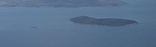
Sloping Island, incorporating the adjacent Sloping Reef, is an island nature reserve, with an area of 117 ha, in Tasmania in south-eastern Australia. It is part of the Sloping Island Group, lying close to the south-eastern coast of Tasmania around the Tasman and Forestier Peninsulas.

Smooth Island, is a privately owned island with an area of 59.31 ha lying close to the south-eastern coast of Tasmania, Australia. The island is part of the Sloping Island Group situated in Norfolk Bay and surrounded by the Tasman and Forestier Peninsulas. The towns Dunalley and Murdunna are nearby. Smooth Island differs from other Tasmanian islands as it has an unencumbered freehold title down to the high-water mark.
Fulham Island is a privately owned island with an area of 10 hectares. It is part of the Sloping Island Group, lying close to the south-eastern coast of Tasmania around the Tasman and Forestier Peninsulas in Tasmania, Australia.
Visscher Island is an island, with an area of 3.4 ha, in south-eastern Tasmania, in Australia.
Arch Rock is a sandstone islet, with an area of 0.44 ha and containing a natural arch, in south-eastern Australia. It is part of the Partridge Island Group, lying close to the south-eastern coast of Tasmania, in the D'Entrecasteaux Channel between Bruny Island and the mainland.

The Friars are four steep dolerite rocks, with a combined area of about 17 ha, in south-eastern Australia. They are part of the Actaeon Island Group, lying close to the south-eastern coast of Tasmania, at the southern entrance to the D'Entrecasteaux Channel between Bruny Island and the mainland. They form part of South Bruny National Park.
Leelinger Island is a flat dolerite island with an area of 1.54 ha in south-eastern Australia. It is part of the Hibbs Pyramid Group, lying close to the central western coast of Tasmania.

King George Island is an island in south-eastern Australia. It is part of the Sloping Island Group, lying close to the south-eastern coast of Tasmania around the Tasman and Forestier Peninsulas. The island was once inhabited and farmed and contains the ruins of two buildings on its eastern side. A conservation covenant is in place on this island.
The Hope Island, part of the Partridge Island Group, is a small island that lies close to the south-eastern coast of Tasmania, Australia. The island is located in the D'Entrecasteaux Channel between Bruny Island and the Tasmanian mainland. Its neighbouring islets are named Faith and Charity, and also the Arch Rock.
South Eastern region of Tasmania, Australia | |||||
|---|---|---|---|---|---|
| Governance former | |||||
| Mountains |
| ||||
| Protected areas, parks and reserves | |||||
| Rivers | |||||
| Harbours, bays, inlets and estuaries | |||||
| Transport | |||||
| Landmarks |
| ||||
| Islands |
| ||||
| Books and newspapers | |||||
| Bioregions | |||||
Coordinates: 42°57′S147°38′E / 42.950°S 147.633°E
| | This Tasman Council geography article is a stub. You can help Wikipedia by expanding it. |