
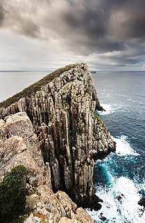
The Tasman National Park is a national park in eastern Tasmania, Australia, approximately 56 kilometres (35 mi) east of Hobart. The 107.5-square-kilometre (41.5 sq mi) park is situated on part of both the Forestier and Tasman peninsulas and encompasses all of Tasman Island.
The Tasman Peninsula, officially Turrakana / Tasman Peninsula, is a peninsula located in south-east Tasmania, Australia, approximately 75 km (47 mi) by the Arthur Highway, south-east of Hobart.
Tasman most often refers to Abel Tasman (1603–1659), Dutch explorer.

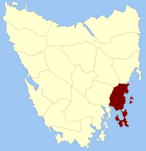
Tasman Council is a local government body in Tasmania, situated in the south-east of the state. Tasman is classified as a rural local government area and has a population of 2,404, the region covers both the Tasman and Forestier peninsulas, with Nubeena the principal town.

The Forestier Peninsula is a peninsula located in south-east Tasmania, Australia, approximately 60 kilometres (37 mi) by the Arthur Highway, south-east of Hobart. The peninsula is connected to mainland Tasmania at East Bay Neck, near the town of Dunalley at its northern end. At Eaglehawk Neck, the southern end of the Forestier Peninsula is connected to the Tasman Peninsula.
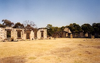
Saltwater River is a rural locality in the local government area (LGA) of Tasman in the South-east LGA region of Tasmania. The locality is about 14 kilometres (8.7 mi) north of the town of Nubeena. The 2016 census has a population of 123 for the state suburb of Saltwater River.

The electoral division of Pembroke is one of the 15 electorates or 'seats' in the Tasmanian Legislative Council or upper house. It is located on Hobart's Eastern Shore and includes a number of suburbs; Risdon Vale, Geilston Bay, Rose Bay, Lindisfarne, Warrane, Mornington, Bellerive, Howrah and Tranmere. In earlier times, the division included most of the east coast of Tasmania as far north as Bicheno, including the Tasman Peninsula.
The Arthur Highway (A9) is a Tasmanian highway which runs from Sorell in the near south to Port Arthur in the far south-east.

The Freycinet Peninsula is a large peninsula located on the eastern coast of Tasmania, Australia. The peninsula is located north of Schouten Island and is contained within the Freycinet National Park.

Schouten Island, part of the Schouten Island Group, is an island with an area of approximately 28 square kilometres (11 sq mi) lying close to the eastern coast of Tasmania, Australia, located 1.6 kilometres (0.99 mi) south of the Freycinet Peninsula and is a part of Freycinet National Park. The Paredarerme name for the island is Tiggana marraboona.
Eaglehawk Neck, officially Teralina / Eaglehawk Neck, is a narrow isthmus that connects the Tasman Peninsula with the Forestier Peninsula, and hence to mainland Tasmania, Australia.
Frederick Henry Bay is a body of water in the southeast of Tasmania, Australia. It is located to the east of the South Arm Peninsula, and west of the Tasman Peninsula. Towns on the coast of the bay include Lauderdale, Seven Mile Beach, Dodges Ferry and Primrose Sands. The bay is accessible via Storm Bay from the south, and provides further access to Norfolk Bay to its east.
Pembroke Land District is one of the twenty land districts of Tasmania which are part of the cadastral divisions of Tasmania. It was formerly one of the 18 counties of Tasmania. It includes Tasman Peninsula and Port Arthur, as well as Forestier Peninsula, Dodges Ferry and Maria Island. The Electoral division of Pembroke is not actually within the land district, but is close by in Monmouth.
The Wedge Island, part of the Tasman Island Group, is an island with an area of 43 hectares lying close to the south-eastern coast of Tasmania, Australia. The island is located in Storm Bay, situated off the Tasman Peninsula.
The Dart Island, part of the Tasman Island Group, is an island, lying close to the south-eastern coast of Tasmania, Australia. The island is located in Norfolk Bay, situated off the Tasman Peninsula.
South Arm Peninsula is a peninsula that lies on the east side of the mouth of the River Derwent south of Hobart in Tasmania, Australia. The peninsula commences at Lauderdale and curves landward or inward on a narrow isthmus that has South Arm situated on the east side of the Derwent, across from Blackmans Bay on the west side. Opossum Bay is the northernmost populated place on the northward curve.
The Norfolk Bay is a body of water in the south east of Tasmania, Australia. The north west aspect of Norfolk Bay is continuous with Frederick Henry Bay. The north east aspect of Norfolk Bay is continuous with Blackman Bay via the Denison Canal.
The Tasman Island Group is a group of islands near the Tasman Peninsula in south-east Tasmania, Australia.

Cape Pillar is a rural locality in the local government area (LGA) of Tasman in the South-east LGA region of Tasmania. The locality is about 27 kilometres (17 mi) south-east of the town of Nubeena. The 2016 census provides a population of 4 for the state suburb of Cape Pillar. It is on the Tasman Peninsula in the Tasman National Park, adjacent to Tasman Island.

The electoral division of Prosser is one of the fifteen electorates in the Tasmanian Legislative Council, it includes the south-east coast of Tasmania, the Sorell township and the Tasman Peninsula. Prosser is named after the Prosser River, which flows through the centre of the division.

