
The Adelaide River is a river in the Northern Territory of Australia.

Darwin Harbour is the body of water close to Darwin in the Northern Territory of Australia. It opens to the north at a line from Charles Point in the west to Lee Point in the east into the Beagle Gulf and connects via the Clarence Strait with the Van Diemen Gulf. It contains Port Darwin, which is flanked by Frances Bay to the east and Cullen Bay to the west.
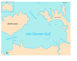
Clarence Strait in northern Australia separates Melville Island from the mainland of Australia. It also connects the Beagle Gulf in the west to the Van Diemen Gulf in the east. It is approximately 50 km (31 mi) north of the city of Darwin.
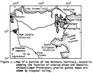
Alligator Rivers is the name of an area in an Arnhem Land region of the Northern Territory of Australia, containing three rivers, the East, West, and South Alligator Rivers. It is regarded as one of the richest biological regions in Australia, with part of the region in the Kakadu National Park. It is an Important Bird Area (IBA), lying to the east of the Adelaide and Mary River Floodplains IBA. It also contains mineral deposits, especially uranium, and the Ranger Uranium Mine is located there. The area is also rich in Australian Aboriginal art, with 1500 sites. The Kakadu National Park is one of the few World Heritage sites on the list because of both its natural and human heritage values. They were explored by Lieutenant Phillip Parker King in 1820, who named them in the mistaken belief that the crocodiles in the estuaries were alligators.

Mataranka is a town and locality in the Northern Territory of Australia located about 420 km (260 mi.) southeast of the territory capital of Darwin, and 107 km (66 mi.) south of Katherine. At the 2016 census, Mataranka recorded a population of 350. 29.5% of residents are Aboriginal and/or Torres Strait Islander.

The Litchfield Council is a local government area of the Northern Territory of Australia on the eastern and southeastern outskirts of the Darwin-Palmerston urban area. The municipality covers an area of 2,903 square kilometres (1,120.9 sq mi), and was created by the Northern Territory government on 6 September 1985.

The Twin Falls is a cascade waterfall on the South Alligator River that descends over the Arnhem Land escarpment within the UNESCO World Heritage–listed Kakadu National Park in the Northern Territory of Australia. In 1980, The Twin Falls area was listed on the now-defunct Register of the National Estate.

The West Arnhem Region is a local government area of the Northern Territory, Australia and is administered by the West Arnhem Regional Council. The region covers an area of 49,675 square kilometres (19,180 sq mi) and had a population of 6,902 in June 2018.
Dundas Strait is a sea passage in the Northern Territory of Australia located between Melville Island and the Cobourg Peninsula. It connects the Timor Sea to the Van Diemen Gulf.

Beagle Gulf is a gulf in the Northern Territory of Australia which opens on its west side to the Timor Sea. The gulf is bounded to the south by the mainland and to the north by Bathurst and Melville Islands. It is connected to Van Diemen Gulf in the east by Clarence Strait. Its south coast includes the natural harbours of Darwin and Bynoe. It is approximately 100 km long and 50 km wide. It surrounds the Quail Island Group.
The Wildman River is a river in the Darwin Coastal bioregion of the Northern Territory, Australia.
The Towns River is a river in the Northern Territory, Australia.
The Ngardok were an indigenous Australian people of the Northern Territory. Nothing is known of the language, which has been extinct since about WW2.
Sandover is a locality in the Northern Territory of Australia located about 1,133 kilometres (704 mi) south of the territory capital of Darwin.
Hotham is a locality in the Northern Territory of Australia located about 62 kilometres (39 mi) east of the territorial capital of Darwin.
Marrakai is a locality in the Northern Territory of Australia located about 76 kilometres (47 mi) east of the territorial capital of Darwin.
Point Stuart is a locality in the Northern Territory of Australia located about 100 kilometres (62 mi) east of the territorial capital of Darwin.
Vernon Islands is a locality in the Northern Territory of Australia located over land and water in the Clarence Strait including the Vernon Islands and which is located about 55 kilometres (34 mi) north-east of the territory capital of Darwin.

Vernon Islands, also known as the Potinga Islands, is an island group in the Northern Territory of Australia located in the Clarence Strait about 55 kilometres (34 mi) north-east of the territory capital of Darwin. The group consists of three islands which were first sighted in 1818 by Europeans on a British navy ship under the command of Phillip Parker King. The group were part of the subject of a successful aboriginal land claim which was resolved after 40 years in 2018 when the Tiwi people received title. All three islands host navigation aids which assist vessels passing through the Clarence Strait. It and some adjoining seabed have had protected area status since 1974 and which has been known as the Vernon Islands Conservation Reserve since 1979. Since 2007, the island group have been located in the locality of Vernon Islands.
Delamere is a locality in the Northern Territory of Australia about 369 kilometres (229 mi) south of the territory capital of Darwin.


