Mainland Australia

Last updated

Mainland Australia
Mainland Australia (orthographic projection).svg
Mainland Australia
Geography
Area7,591,608 km2 (2,931,136 sq mi)
Administration
Demographics
Population25,895,442

Mainland Australia is the main landmass of the Australian continent, excluding the Aru Islands, New Guinea, Tasmania, and other Australian offshore islands. The landmass also constitutes the mainland of the territory governed by the Commonwealth of Australia, and the term, along with continental Australia, can be used in a geographic sense to exclude surrounding continental islands and external territories. Generally, the term is applied to the states of New South Wales, [lower-alpha 1] Queensland, South Australia, Victoria, and Western Australia, as well as the Australian Capital Territory, Jervis Bay Territory, and Northern Territory.

Contents

The term is typically used when referring to the relationship between Tasmania and the other Australian states, [1] [2] in that people not from Tasmania are referred to as mainlanders. [3] Tasmania has been omitted on a number of occasions from maps of Australia, reinforcing the divide between Tasmania and the mainland. The 1982 Commonwealth Games in Brisbane left Tasmania off the map of Australia during the opening ceremony, as did the designs of the Australian Swim Team uniform for the 2014 Commonwealth Games in Glasgow. [3]

The land mass covers 7,591,608 km2 (2,931,136 sq mi), about 98.7% of the area of the country of Australia and 1.5% of Earth's surface. [4] It is sometimes described as an island, in which case it would be the largest island by area–more than three times the size of Greenland. [5] Its population is about 25.9 million, 98% of Australia's total population. Mainland Australia has a variety of climatic regions, ranging from tropical rainforests and deserts to cool temperature rainforests to snow-covered mountains. [6] It is in these mainland regions that much of Australia's native flora and fauna can be found.

History

Early in the Cretaceous period, 130 million years ago, [7] Australia (and Antarctica) separated from a supercontinent known as Gondwana. Antarctica's separation from Australia began roughly 85 million years ago, at a rate of a few millimetres per year. [8] It took over 30 million years (53 million years ago), toward the end of the Palaeocene epoch, [7] for Australia to fully separate from Antarctica and set course for where we see the two continents today.

During the last ice-age around 35,000 years ago, [9] sea levels (around Australia) dropped by 120 metres (390 ft), developing a continuous stretch of land between now day Papua New Guinea, Australia and Tasmania. Over the next 6,000 [10] years the ice gradually melted, increasing sea-levels, cutting off Papua New Guinea and Tasmania from mainland Australia.

Prehistory

It has been estimated that Australian Aborigines occupied mainland Australia up to 50,000 to 60,000 [11] years ago, well before the last ice-age. Although an exact figure has not been decided on, numerous DNA studies all confirm that Aboriginal Australians are one of the oldest living populations in the world [12] outside of Africa. Prior to the arrival of Europeans on the Australian mainland in the late 18th century, over 500 [13] different clan groups (nations) each with unique cultures, beliefs and languages inhabited territories on the mainland. Currently, Indigenous people living on the mainland make up 2.4% [13] of the total Australian population, encompassing over 250 language groups. [14]

European colonization

The first documented encounter of the Australian mainland was by Willem Janszoon in 1606, as he sailed around Australia's north coast arriving in present-day Cape York, Queensland. [15] These explorations led way to the term 'Terra Australis', Latin for South Land, which was hypothesised on the notion there must be land in the Southern Hemisphere to balance the land mass in the Northern Hemisphere. [16] This encounter led several other Dutch, Spanish, Portuguese and British journeyings to Terra Australis throughout the 17th and 18th century, progressively mapping what we now know to be as (mainland) Australia. The most famous and well documented expedition of Australia occurred 164 years after Janszoon's journey, through British navigator and explorer James Cook. He documented the first interaction of the Eastern Australian coastline, and on 23 April 1770, Cook made the first recorded observation of Indigenous Australians [17] at nowadays Brush Island. This journey, coupled with numerous other reports, ultimately led the British to establish a penal colony in Australia, firstly at Botany Bay.

Geography

Physical map of Australia Australia relief map.jpg
Physical map of Australia

The Australian mainland's geology and climate is one of its defining features. Despite being surrounded by ocean, approximately 20% of the Australian mainland is classified as desert. [6] This is due to the extremely variable rain patterns across the mainland. Toward the barren centre of the mainland, the rainfall pattern is concentric and sparse, whereas there is higher intensity rainfall toward the mainland's tropics and coastal areas. Australia lies on the middle of the Indo-Australian tectonic plate [18] and as a result is not influenced by any severe tectonic activity. Over millions of years, the shifting of these tectonic plates has seen the Australian mainland undergo many physical changes. Mountain ranges and seas have come and gone, and the forces of weathering and erosion have formed much of the mainlands current topography. [19] These physical changes developed four primary landform divisions spread throughout the mainland states and territories; the Coastal Plains, the Eastern and Southern highlands, the Central Lowlands (and Deserts) and the Western and Northern Plateaus (and Basins).

Coastal Plains

Eastern coast of Australia East Coast of Australia.jpg
Eastern coast of Australia

Along the Eastern seaboard of the mainland are the Coastal Plains; a narrow strip of land along the East coast of Australia from Queensland to Victoria. [20] This division is host to some of the mainlands major cities, namely, Brisbane, Sydney and Melbourne, due to its hospitable conditions. Some sources refer to the Coastal Plains as the entire coastline of the mainland, outspreading beyond the East Coast. [19]

Eastern Highlands

Approximately 100 km (62 mi) inland, the Eastern Highlands (including the Great Dividing Range) cover almost 10% of the mainland. [21] Incorporating several mountain ranges which extend 3,700 km (2,300 mi) [22] the Highlands run parallel to the east coast of the mainland; covering Queensland, New South Wales, the Australian Capital Territory and Victoria. The highlands were formed around 80 million years ago, [23] and are some of the oldest and most prominent in the world. This area is very rugged and primarily consists of a series of tablelands and plateaus. The highlands are much more prominent toward the south east of the mainland and form the Southern Highlands, which are located across (south) New South Wales, the Australian Capital Territory and Victoria. These Southern highlands experience snowfall for more than half the year during the winter due to their higher altitude.

Central Lowlands

Occupying approximately 25% of the Australian mainland, [21] the Central Lowlands (and Deserts) are low-lying with an average height of under 200 metres (660 ft) above sea level. It is home to the Sturt and Simpson deserts and closer to Central Australia lie some desert mountain ranges (MacDonnell and Musgrave). The Central Lowlands incorporates three primary drainage basins: in the North, the Carpentaria Lowlands, Lake Eyre toward the centre and the Murray-Darling Basin down South. [19] The lowest point on the mainland is found in this division at Lake Eyre, at 50m below sea level. [24]

Western Plateau

Western Plateau, Northern Territory Western Plateau.jpg
Western Plateau, Northern Territory

Approximately 144 to 65 million years ago (Cretaceous period), there lay a great inland sea, stretching over one quarter of the mainland. [25] The evaporation of this ocean left behind what we now know as the Western Plateau. The Western and Northern Plateaus incorporate nearly all Western Australia and the Northern Territory and parts of South Australia. Over one-third of the mainland, the Plateaus are made of one stable block of igneous and metamorphic rock which is up to 3.6 billion years old. [21] Despite this, the Plateau is a huge area of tablelands, averaging 500m above sea level in some parts. [19] It is home to Uluru, Kata Tjuta, the Finke River, the Victorian Desert, the Great Sandy Desert and the Gibson Desert. Much of the Western Plateau receives minimal rainfall and thus appears red in colour. Conversely, the Northern Plateau experiences heavy rainfall throughout the wet season (November to April), [24] due to its more tropical location compared to the Western Plateau.

Natural resources

Australia's separation from the other continents resulted in a long period of uplift, erosion and thick terrigenous deposition in rift valleys. [7] It was these processes which over millions of years has led to the accumulation of Australia's main known mineral, oil and gas resources. Most of Australia's oil and gas exploration occurs off the mainland. However, on the mainland, the abundance of minerals (and thus metals) has formed the basis of Australia's dependence on mining; [26] exporting much of these natural occurring resources overseas.

Super Pit gold mine on Kalgoorlie's Golden Mile in Western Australia Kalgoorlie The Big Pit DSC04498.JPG
Super Pit gold mine on Kalgoorlie's Golden Mile in Western Australia

Mining

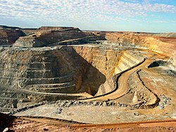
The Australian mainland is host to some of the world's largest open-cut and underground mines. Across the mainland states (besides the ACT), there are over 350 operating mines, producing 19 useful rocks and minerals. These mines allow Australia to be one of the world's largest producers of iron ore, coal, bauxite (aluminium ore), manganese, nickel, copper, gold, silver, cobalt, lead, copper, uranium, opal and diamond. [27] Some of the largest mines on the Australian mainland are listed below:

Major mines on the Australian mainland
MineOwnerStateTypeMinerals producedSize
Mount Arthur BHP New South Wales Open cut Coal

Gold

12 km2
Peak Downs BHP Queensland Open cut Coal688 km2 [28]
Cannington South32 Queensland Underground Silver

Lead

5.25 km (multiple tunnels) [29]
Carmichael Bravus Mining and Resources (Adani) Queensland Open cutCoal447 km2
Olympic Dam BHP South Australia Underground Copper

Uranium

Gold

Silver

450 km (multiple tunnels) [30]
Argyle Rio Tinto Western Australia Underground Diamond 40 km (multiple tunnels) [30]
Boddington Newmont Western Australia Open cutGold

Copper

212 km2 [31]
Fimiston Kalgoorlie Consolidated Gold Mines Western Australia Open cutGold5.25 km2 (360m deep) [30]
Roy Hill Hancock Prospecting Western Australia Open cut

Underground

Iron ore 4,000 km2
Worsley Alumina South32 Western Australia Open cut Bauxite 5,000 km2 [32]
Yandicoogina Rio Tinto Western Australia Open cutIron ore267 km2 [33]

Renewables

The Australian mainland's various geology and climate, has led to the increased utilisation of renewable energy (solar, wind and hydro) over recent decades. [34] In 2021, approximately 28.9% of the mainland's total electricity generation was from renewable energy sources with South Australia at 66.5% renewable energy generation, Victoria at 33.4%, Western Australia at 31.5%, New South Wales at 26.0% and Queensland at 19.6%. [35] The majority of this renewable energy was generated through wind and solar, proportionally contributing 35.9% and 38.3% respectively.

Politics

Australian political decisions are typically deliberated and enacted within the limits of homeland (mainland Australia) soil. Despite Tasmania being one of Australia's six British establishment colonies, Tasmania has often been looked over due to the state's small size and general isolation. This is observed through the states and territories of mainland Australia representing 146 of the 151 members in Parliament. [36]

State formation

From 1788 to 1859, Britain established five colonies on the Australian mainland, [37] and one in Tasmania. All six colonies were constitutionally connected to Britain, each with their own parliament and courts, with their respective laws subject to the laws of British Parliament.

These colonies formed the six states of Australia; New South Wales, Victoria, Western Australia, South Australia (included the Northern Territory at this time), Queensland and Tasmania. In 1901, the six states were united as the Commonwealth of Australia, under a new federal constitution. [38] In 1911, the Northern Territory was transferred from South Australia to the Commonwealth and formed a territory. [37]

Capital selection

Location of Canberra Canberra Location Screenshot from Wikipedia.jpeg
Location of Canberra

After Federation in 1901, [38] it was always assumed the Australian capital would be on the mainland. However, the location of the capital sparked years of negotiating between politicians in New South Wales and Victoria, the two most prominent states, who each wanted their capital, Sydney and Melbourne respectively, to become the new country's capital.

After years of debate to no avail, the two states decided on a compromise that met the requirements of the Australian Constitution. A separate territory (the Australian Capital Territory) was to be established on land given by New South Wales, however it must be at least 100 miles (160 km) from Sydney. [39] This territory would contain the official capital of Australia, and Parliament would sit in Melbourne until the city (now Canberra) was built. In 1909, this compromise was agreed upon and was finally legislated in 1911. [40]

On 12 March 1913, Canberra was officially named as the capital of Australia. [41] In 1915, Jervis Bay territory was added to the Australian Capital Territory to ensure the Commonwealth had a seaport. [42]

See also

Notes

  1. Parts of New South Wales, such as Lord Howe Island, are part of the mostly submerged continent of Zealandia.

Related Research Articles

<span class="mw-page-title-main">Protected areas of Australia</span> Protected areas in Australia

Protected areas of Australia include Commonwealth and off-shore protected areas managed by the Australian government, as well as protected areas within each of the six states of Australia and two self-governing territories, the Australian Capital Territory and the Northern Territory, which are managed by the eight state and territory governments.

<span class="mw-page-title-main">Index of Australia-related articles</span> Alphabetical list of articles related to Australia

The following is an alphabetical list of articles related to Australia.

<span class="mw-page-title-main">King Island (Tasmania)</span> Island in the Bass Strait

King Island is an island in the Bass Strait, belonging to the Australian state of Tasmania. It is the largest of four islands known as the New Year Group and the second-largest island in Bass Strait. The island's population at the 2016 census was 1,585 people, up from 1,566 in 2011. The local government area of the island is the King Island Council.

The parliaments of the Australian states and territories are legislative bodies within the federal framework of the Commonwealth of Australia.

<span class="mw-page-title-main">Australian Alps</span> Bioregion in Australia

The Australian Alps are a mountain range in southeast Australia. It comprises an interim Australian bioregion, and is the highest mountain range in Australia. The range straddles the borders of eastern Victoria, southeastern New South Wales, and the Australian Capital Territory. It contains Australia's only peaks exceeding 2,000 m (6,600 ft) in elevation, and is the only bioregion on the Australian mainland in which deep snow falls annually. The range comprises an area of 1,232,981 ha.

<span class="mw-page-title-main">Proposals for new Australian states</span>

There have been numerous proposals for the creation or incorporation of new states of Australia, since the late 19th century. Chapter VI of the Constitution of Australia provides for the admission of new states to the federation. Proposals have included admitting territories to statehood, admitting independent countries, and forming new states from parts of existing states. However, no new states have been added since the federation of six former British self-governing colonies in 1901, as states of the new Commonwealth of Australia.

<span class="mw-page-title-main">Time in Australia</span> Time zones in Australia

Australia uses three main time zones: Australian Eastern Standard Time, Australian Central Standard Time and Australian Western Standard Time.

<span class="mw-page-title-main">States and territories of Australia</span> First-level administrative subdivisions of Australia

The states and territories are the second level of government of Australia. The states are administrative divisions that are self-governing polities that are partly sovereign, having ceded some sovereign rights to the federal government. They have their own constitutions, legislatures, executive governments, judiciaries and law enforcement agencies that administer and deliver public policies and programs. Territories can be autonomous and administer local policies and programs much like the states in practice, but are still legally subordinate to the federal government.

<span class="mw-page-title-main">Australia</span> Country in Oceania

Australia, officially the Commonwealth of Australia, is a sovereign country comprising the mainland of the Australian continent, the island of Tasmania, and numerous smaller islands. Australia is the largest country by area in Oceania and the world's sixth-largest country. Australia is the oldest, flattest, and driest inhabited continent, with the least fertile soils. It is a megadiverse country, and its size gives it a wide variety of landscapes and climates, with deserts in the centre, tropical rainforests in the north-east, tropical savannas in the north, and mountain ranges in the south-east.

<span class="mw-page-title-main">Territorial evolution of Australia</span>

The first colonies of the British Empire on the continent of Australia were the penal colony of New South Wales, founded in 1788, and the Swan River Colony, founded in 1829. Over the next few decades, the colonies of New Zealand, Queensland, South Australia, Van Diemen's Land, and Victoria were created from New South Wales, as well as an aborted Colony of North Australia. On 1 January 1901, these colonies, excepting New Zealand, became states in the Commonwealth of Australia. Since federation, the internal borders have remained mostly stable, except for the creation of some territories with limited self-government: the Northern Territory from South Australia, to govern the vast, sparsely populated centre of the country; the split of the Northern Territory into Central Australia and North Australia, and then the quick merger of those back into the Northern Territory; and the Australian Capital Territory, a federal district ceded from New South Wales.

<span class="mw-page-title-main">Energy policy of Australia</span> Overview of the energy policy of Australia

The energy policy of Australia is subject to the regulatory and fiscal influence of all three levels of government in Australia, although only the State and Federal levels determine policy for primary industries such as coal. Federal policies for energy in Australia continue to support the coal mining and natural gas industries through subsidies for fossil fuel use and production. Australia is the 10th most coal-dependent country in the world. Coal and natural gas, along with oil-based products, are currently the primary sources of Australian energy usage and the coal industry produces over 30% of Australia's total greenhouse gas emissions. In 2018 Australia was the 8th highest emitter of greenhouse gases per capita in the world.

<span class="mw-page-title-main">Outline of Australia</span> Continent and country

This outline of Australia is an overview of and topical guide to various aspects of the country of Australia.

The AFL National Championships is an annual Australian national underage representative Australian rules football tournament. It is seen as one of the main pathways towards being drafted into a team in the fully professional Australian Football League (AFL).

<span class="mw-page-title-main">Geography of Australia</span>

The geography of Australia encompasses a wide variety of biogeographic regions being the world's smallest continent, while comprising the territory of the sixth-largest country in the world. The population of Australia is concentrated along the eastern and south-eastern coasts. The geography of the continent is extremely diverse, ranging from the snow-capped mountains of the Australian Alps and Tasmania to large deserts, tropical and temperate forests, grasslands, heathlands and woodlands.

The suffix -land, which can be found in the names of several countries or country subdivisions, indicates a toponymy - a land. The word derived from the Old English land, meaning "ground, soil", and "definite portion of the earth's surface, home region of a person or a people, territory marked by political boundaries". It evolved from the Proto-Germanic *landą and from the Proto-Indo-European *lendʰ- "land, open land, heath".

<span class="mw-page-title-main">Australia (continent)</span> One of Earths seven main divisions of land

The continent of Australia, sometimes known in technical contexts by the names Sahul, Australia-New Guinea, Australinea, or Meganesia to distinguish it from the country of Australia, is located within the Southern and Eastern hemispheres. The continent includes mainland Australia, Tasmania, the island of New Guinea, the Aru Islands, the Ashmore and Cartier Islands, most of the Coral Sea Islands, and some other nearby islands. Situated in the geographical region of Oceania, Australia is the smallest of the seven traditional continents.

Suffrage in Australia is the voting rights in the Commonwealth of Australia, its six component states and territories, and local governments. The colonies of Australia began to grant universal male suffrage from 1856, with women's suffrage following between the 1890s and 1900s. Some jurisdictions introduced racial restrictions on voting from 1885. Such restrictions had been eradicated by the 1960s. Today, the right to vote at all levels of government is held by citizens of Australia over the age of 18 years.

<span class="mw-page-title-main">South Eastern Highlands</span> Region in Australia

The South Eastern Highlands is an interim Australian bioregion in eastern Australia, that spans parts of the states and territories of New South Wales, the Australian Capital Territory, and Victoria. The bioregion comprises 8,375,961 hectares and is approximately 3,860 kilometres (2,400 mi) long. The Australian Alps as well as the South West Slopes bound the region from the south and west; and to the northeast, the Sydney Basin bioregion, as well as the bioregion of the South East Corner, to the east.

References

  1. "A quick look back". Basslink. Hydro Tasmania. Archived from the original on 18 July 2016. Retrieved 24 July 2016.
  2. "Ex-interstate vehicles". Department of State Growth, Transport. Tasmanian Government. Archived from the original on 24 March 2020. Retrieved 24 July 2016.
  3. 1 2 "Separation of Tasmania". National Museum of Australia. NMA. Archived from the original on 30 December 2014. Retrieved 24 July 2016.
  4. "Area of Australia - States and Territories | Geoscience Australia". Ga.gov.au. 12 January 2001. Retrieved 28 November 2018.
  5. McMahon, Elizabeth (2010). "Australia, the Island Continent: How Contradictory Geography Shapes the National Imaginary". Space and Culture. 13 (2): 178–187. Bibcode:2010SpCul..13..178M. doi:10.1177/1206331209358224. S2CID   131158261.
  6. 1 2 "The Australian Continent". australia.gov.au. Australian Government.
  7. 1 2 3 Veevers, J.J.; McElhinny, M.W. (July 1976). "The separation of Australia from other continents". Earth-Science Reviews. 12 (2–3): 139–143. Bibcode:1976ESRv...12..139V. doi:10.1016/0012-8252(76)90003-9.
  8. "Antarctic Geology". Australian Antarctic Program. Australian Government. October 2021.
  9. corporateName=National Museum of Australia; address=Lawson Crescent, Acton Peninsula. "National Museum of Australia - Separation of Tasmania". www.nma.gov.au. Retrieved 12 April 2021.{{cite web}}: CS1 maint: multiple names: authors list (link)
  10. Hope, Pandora (2005). "The weather and climate of Australia at the Last Glacial Maximum". School of Earth Sciences, the University of Melbourne.
  11. Clarkson, Chris; Arnold, Lee (2017). "Human occupation of northern Australia by 65,000 years ago". Nature. 457 (7663): 306–310. Bibcode:2017Natur.547..306C. doi:10.1038/nature22968. hdl: 2440/107043 . PMID   28726833. S2CID   205257212.
  12. Curnoe, Darren (23 September 2011). "DNA confirms Aboriginal culture one of Earth's oldest". Australian Geographic.
  13. 1 2 "Our people". australia.gov.au. Australian Government.
  14. "Indigenous Australians: Aboriginal and Torres Strait Islander people". IATSIS. Australian Government. 12 July 2020.
  15. Sigmond, J.P.; Zuiderbaan, L.H. (1979). Dutch Discoveries of Australia: Shipwrecks, treasures and early voyages off the West Coast. Adelaide: Rigby.
  16. Pearson, Michael (2005). Great Southern Land: The maritime exploration of Terra Australis. Australian Government. ISBN   0642551855.
  17. "Cook's Journal: Daily Entries, 22 April 1770" . Retrieved 21 September 2011.
  18. Young, Emma (6 October 2011). "Earthquakes in Australia". Australian Geographic.
  19. 1 2 3 4 Swanson, Louise; Kriewaldt, Jeana; Ford, Nicole; Bowden, Karen; Harrison, Adrian (18 November 2016). Geoactive (4 ed.). Jacaranda. ISBN   9780730330325.
  20. "Landforms of Australia". Skwirk.com.au. 2014.
  21. 1 2 3 "Landforms: Major Landforms and Divisions of Australia". The Australian Environment.
  22. Tikkanen, Amy. "Great Dividing Range". Britannica.
  23. Monroe, M (21 October 2016). "Australia: The Land Where Time Began". austhrutime. Kangaroo Press.
  24. 1 2 "Australian Landforms and their History" (Government Document). Geoscience Australia. Australian Government. 15 May 2014.
  25. Bowler, James; Wasson, Robert (1984). "Glacial age environments of inland Australia. Late Cainozoic Palaeoclimates of the Southern Hemisphere". 1. 1: 183–208.
  26. Knights, P; Hood, M. "The minerals sector". Parliament of Australia.
  27. "Australian Mineral Facts". Geoscience Australia. Australian Government. 4 March 2018.
  28. "Peak Downs/Caval Ridge Coal Mines". Thiess.
  29. "Cannington Silver and Lead Mine, Queensland". Mining Technology.
  30. 1 2 3 Casey, JP (7 March 2019). "Super mines: Australia's biggest mining projects". Mining Technology.
  31. Newmont 2020 Annual Report (PDF). Western Australia: Newmont. 31 December 2020.
  32. "Worsley Alumina Refinery & Boddington Bauxite Mine Site Tour" (PDF). Western Australia: South32. 6 December 2018.
  33. Zhou, Vanessa (13 May 2019). "Rio Tinto cleared to expand West Angelas iron ore project". Strate Worldwide.
  34. de Atholia, Timothy (19 March 2020). "Renewable Energy Investment in Australia" (Bulletin). Bulletin (March).
  35. Clean Energy Council Australia. "Clean Energy Australia Report 2022" (PDF). Clean Energy Australia. Retrieved 8 September 2022.
  36. "Number of Members". Parliament of Australia. Australian Government.
  37. 1 2 "Documenting a Democracy - Places". Museum of Australian Democracy.
  38. 1 2 "The Federation of Australia". Parliamentary Education Office. Commonwealth of Australia.
  39. "Defining Moments - Federation". National Museum of Australia. Australian Government.
  40. "Federation and the National Capital" (Government Fact Sheet). National Capital Authority. Australian Government.
  41. Coombes, Jennifer (8 March 2013). "The Naming of Canberra, 1913". National Film and Sound Archive of Australia.
  42. "A quick history of Canberra". Visit Canberra. ACT Government. 1 November 2019.

27°S133°E / 27°S 133°E / -27; 133