Councils of Tasmania are the 29 administrative districts of the Australian state of Tasmania. Local government areas (LGAs), more generally known as councils, are the tier of government responsible for the management of local duties such as road maintenance, town planning and waste management.

Ripley is a town in the Amber Valley borough of Derbyshire, England. Engineers from Ripley came up with some early improvements to the railway system.

Margate is a small seaside town on the Channel Highway between North-West Bay and the Snug Tiers, 7 kilometres (4 mi) south of Kingston in Tasmania, Australia. It is mostly in the Kingborough Council area, with about 4% in the Huon Valley Council LGA.
Kingborough Council is a local government body in Tasmania, and one of the five municipalities that constitutes the Greater Hobart Area. Kingborough is classified as an urban local government area and has a population of 37,734, it covers the transition from the southern urban areas of Hobart through Kingston, as well as encompassing Bruny Island.
Fern Tree is a rural / residential locality in the local government areas (LGA) of Hobart (64%) and Kingborough (36%) in the Hobart LGA region of Tasmania. The locality is about 9 kilometres (5.6 mi) south-west of the town of Hobart. The 2016 census provides a population of 726 for the state suburb of Fern Tree.

Gleadless is a suburb and parish within the City of Sheffield, it lies five km south east of the city centre. It is bordered by the adjoining suburbs of Gleadless Valley to the west, Frecheville to the east and Intake to the north. The land to the south is the rural area of North East Derbyshire district which is outside the city boundary. Gleadless was formerly a country hamlet, then village before becoming part of the expanding city of Sheffield in 1921. The word Gleadless comes from the Old English language and means either “forest clearings haunted by a kite” or “bright clearing”.
The 1967 Tasmanian fires were an Australian natural disaster which occurred on 7 February 1967, an event which came to be known as the Black Tuesday bushfires. They were the most deadly bushfires that Tasmania has ever experienced, leaving 62 people dead, 900 injured and over seven thousand homeless.

Creswell Model Village is an arts and crafts style model village in the village of Creswell, Derbyshire, England. The pit village was built in 1895 by the Bolsover Colliery Company to designs by architect Percy B. Houfton for the workers of Creswell Colliery on land leased from the Welbeck Estate. Influenced by garden village principles, it provided the workers with modern facilities; it had a tramway to deliver coal to the houses. Designed around a large oval village green with an access road through the centre, the houses are of varying styles. The Model as it is known, has been refurbished.

Garnant is a Welsh mining village in the valley of the River Amman in Carmarthenshire, north of Swansea. Like the neighbouring village of Glanamman it experienced a coal-mining boom in the 19th and early 20th centuries, but the last big colliery closed in 1936 and coal has been extracted fitfully since then. The village has the only Commissioners' church built in southwest Wales, traditionally a Methodist region.

Merewether is a suburb of Newcastle, New South Wales, Australia, located 3 km (2 mi) from Newcastle's central business district with a population of around 11,000. The suburb stretches 3 km (2 mi) from Merewether Beach in the east to Adamstown in the west.

The Somerset Coalfield in northern Somerset, England is an area where coal was mined from the 15th century until 1973. It is part of a larger coalfield which stretched into southern Gloucestershire. The Somerset coalfield stretched from Cromhall in the north to the Mendip Hills in the south, and from Bath in the east to Nailsea in the west, a total area of about 240 square miles (622 km2). Most of the pits on the coalfield were concentrated in the Cam Brook, Wellow Brook and Nettlebridge Valleys and around Radstock and Farrington Gurney. The pits were grouped geographically, with clusters of pits close together working the same coal seams often under the same ownership. Many pits shared the trackways and tramways which connected them to the Somerset Coal Canal or railways for distribution.

The Channel Football Club was an Australian rules football club that last played in the Old Scholars Football Association (Tas), also known as Old Scholars, from 2009 to 2015.
Previous to that it was a member of the Southern Football League from 1996 to 2008 and the Huon Football Association from 1967 to 1995.
The Channel Football Club's emblem was the Saints, although it changed to the Sharks from 2009 to 2015.
Their home ground, Snug Park, was situated right alongside the beach at the end of Beach Road, Snug.

The Ridgacre Branch is a canal branch of the Wednesbury Old Canal, part of the Birmingham Canal Navigations, in the West Midlands, England. It opened in 1828, to serve collieries and iron works, and was disused by the 1960s. Except for its branches and a small section at the eastern end, which have been filled in, most of it is still in water, but it is not navigable as a low-level bridge carrying the Black Country New Road spans the entrance.
Snug is a small coastal town on the Channel Highway located 30 kilometres (19 mi) south of Hobart in Tasmania, Australia. At the 2006 census, Snug had a population of 881. Snug is a part of the Municipality of Kingborough, but with about 7% in the Huon Valley Council LGA.
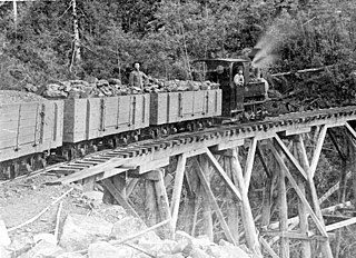
The Sandfly Colliery Tramway was a 20 km (12 mi), 2 ft narrow gauge tramway linking the Kaoota Mine to Margate, Tasmania. Constructed in 1905–06, the Tramway climbed 457 m (1,499 ft) above sea level and crossed ten bridges. After coal mining ceased the tramway was used to transport logs, fruit and passengers. The line was lifted and abandoned in 1922 after bushfires destroyed several bridges along the line. Currently, 6 km (3.7 mi) of the old track is used as cycling/walking tracks, while the remainder of the old line is on private property.

Lower Longley is a rural locality situated on the borders of the Kingborough and Huon Valley local government areas, which straddles the Huon Highway and is made up primarily of acreage properties. Lower Longley had 131 inhabitants as of the 2011 Australian Census. Despite being called Lower Longley, the suburb is physically higher than neighbouring Longley.

Harraton is a former civil parish and now a suburb in the unparished area of the town of Washington, in the City of Sunderland metropolitan borough, in Tyne and Wear, England. Harraton is near the River Wear and is 3 miles north-east of Chester-le-Street, 2 miles south-west of Washington town centre and 9 miles south-southwest of Sunderland. When nearby Washington was founded as a new town under the New Towns Act in 1964, Harraton alongside the neighboring villages of Chaters-Hough, Fatfield, Cox Green and Picktree became suburbs of Washington forming the southern suburbs of the town. Certain developments also took place for overspill for the nearby towns of Chester Le Street and Houghton-le-Spring. It is on the main road serving Seahouses and the northern coast. In 1961 the parish had a population of 3,565.

Conara is a rural locality in the local government area (LGA) of Northern Midlands in the Central LGA region of Tasmania. The locality is about 50 kilometres (31 mi) south-east of the town of Longford. The 2016 census provides a population of 130 for the state suburb of Conara.
Lou Rae is a Tasmanian author and historian of the West Coast of Tasmania.
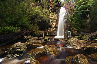
Kaoota is a rural residential locality in the local government areas (LGA) of Kingborough and Huon Valley in the Hobart and South-east LGA regions of Tasmania. The locality is about 18 kilometres (11 mi) south-west of the town of Kingston. The 2016 census provides a population of 202 for the state suburb of Kaoota.

