Councils of Tasmania are the 29 administrative districts of the Australian state of Tasmania. Local government areas (LGAs), more generally known as councils, are the tier of government responsible for the management of local duties such as road maintenance, town planning and waste management.

Kingston is a town on the outskirts of Hobart, Tasmania, Australia. Nestled 12 km south of the city between and around several hills, Kingston is the seat of the Kingborough Council, and today serves as the gateway between Hobart and the D'Entrecasteaux Channel region, which meets the Derwent River nearby. It is one of the fastest growing regions in Tasmania. The Kingston-Huntingfield statistical area had an estimated population of 11,200 in June 2012.

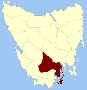
Kingborough Council is a local government body in Tasmania, and one of the five municipalities that constitutes the Greater Hobart Area. Kingborough is classified as an urban local government area and has a population of 37,734, it covers the transition from the southern urban areas of Hobart through Kingston, as well as encompassing Bruny Island.

Huon Valley Council is a local government body in Tasmania, covering most of the south of the state. Huon Valley is classified as a rural local government area and has a population of 17,219, towns and localities of the region include Cygnet, Dover, Franklin, Geeveston, Southport and the largest principal town, Huonville.
Fern Tree is a rural / residential locality in the local government areas (LGA) of Hobart (64%) and Kingborough (36%) in the Hobart LGA region of Tasmania. The locality is about 9 kilometres (5.6 mi) south-west of the town of Hobart. The 2016 census provides a population of 726 for the state suburb of Fern Tree.

Neika is a rural locality in the local government areas (LGA) of Hobart and Kingborough in the Hobart LGA region of Tasmania. The locality is about 20 kilometres (12 mi) south-west of the town of Hobart. The 2016 census provides a population of 198 for the state suburb of Neika. It is a suburb of Hobart, to the north-west of Kingston.

The Huon Valley, or simply the Huon is a valley and geographic area located in southern Tasmania, Australia. The largest town is Huonville, with other smaller towns spread across the area. It includes Australia's most southern permanent settlement at Southport. The Huon Valley Council area had a population of 15,140 in 2011. Famed for its apple growing, the Valley was first settled by British colonists in the 1820s; prior to settlement the Huon Valley area was inhabited by the Mouheneenner, Nuenonne, Mellukerdee and Lyluequonny people.

Kingston Beach is a residential locality in the local government area (LGA) of Kingborough in the Hobart LGA region of Tasmania. The locality is about 2 kilometres (1.2 mi) south-east of the town of Kingston. The 2016 census provides a population of 1990 for the state suburb of Kingston Beach.

Kingborough Tigers Football Club is an Australian rules football club, based at Kingston, Tasmania that formerly competed in the Southern Football League in Tasmania before progressing to representation in the statewide Tasmanian State Football League (TSL) in 2014.
Buckingham Land District is one of the twenty land districts of Tasmania which are part of the Lands administrative divisions of Tasmania. It was formerly Buckingham County, one of the 18 counties of Tasmania and one of the first eleven proclaimed in 1836 and is bordered to the north by the River Derwent, and to the south by the Huon River. It includes Bruny Island. Hobart is located in the county. It was named after the then county of England.

Mount Arthur is a mountain in the northern region of Tasmania, Australia. With an elevation of 1,188 metres (3,898 ft) above sea level, the mountain is located north-east of Launceston, near the town of Lilydale.

Smooth Island, is a privately owned island with an area of 59.31 ha lying close to the south-eastern coast of Tasmania, Australia. The island is part of the Sloping Island Group situated in Norfolk Bay and surrounded by the Tasman and Forestier Peninsulas. The towns Dunalley and Murdunna are nearby. Smooth Island differs from other Tasmanian islands as it has an unencumbered freehold title down to the high-water mark.

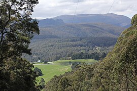
Mountain River is a rural locality in the local government area (LGA) of Huon Valley in the South-east LGA region of Tasmania. The locality is about 15 kilometres (9.3 mi) north-east of the town of Huonville. The 2016 census provides a population of 559 for the state suburb of Mountain River. The locality increasingly is a lifestyle destination, being only about 30 minutes south of the Tasmanian capital Hobart by road.

Sandfly is a suburb in the Kingborough Council local government area in Tasmania, Australia. A region of the Franklin Electorate, Sandfly is a historic area that sits between the suburbs of Longley, Lower Longley, Allens Rivulet, Margate, Leslie Vale and Kaoota. The population of Sandfly in 2011 was 156.

Cathedral Rock is a towering dolerite rock formation located in Wellington Park in south-eastern Tasmania.

Henry Hunter (1832–1892) was a prominent architect and civil servant in Tasmania and Queensland, Australia. He is best known for his work on churches. During his life was also at various times a state magistrate of Tasmania, a member of the Tasmanian State Board of Education, the Hobart Board of Health, a Commissioner for the New Norfolk Insane Asylum and President of the Queensland Institute of Architects.
Pelverata is a rural locality in the local government areas (LGA) of Huon Valley and Kingborough in the South-east and Hobart LGA regions of Tasmania. The locality is about 22 kilometres (14 mi) south-west of the town of Kingston. The 2016 census provides a population of 206 for the state suburb of Pelverata. It is a town in Tasmania, Australia, to the east of Huonville. It is mainly in the Huon Valley Council area, with about 4% in the Kingborough Council LGA.

Isle of the Dead is a small island adjacent to Port Arthur, Tasmania, Australia. The island is historically significant as it retains an Aboriginal coastal shell midden, one of the first recorded sea-level benchmarks, and one of the few preserved Australian convict-period burial grounds. Isle of the Dead forms part of the Port Arthur Historic Site. This site is part of Australian Convict Sites and is listed as a World Heritage Property, as it represents convictism in the era of British colonisation.

Pulse FM Hobart is an online content publisher and radio station based in Tasmania, Australia. Pulse operates as a radio station and an online content publisher. Pulse FM targets a 15 - 35 age demographic, while the Pulse social media platforms target a varied demographic.
Longley is a rural residential locality in the local government area of Kingborough in the Hobart region of Tasmania. It is located about 13 kilometres (8.1 mi) west of the town of Kingston. The 2016 census has a population of 234 for the state suburb of Longley.