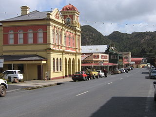
Queenstown is a town in the West Coast region of the island of Tasmania, Australia. It is in a valley on the western slopes of Mount Owen on the West Coast Range.
Castlemaine is a town in west central Victoria, Australia, in the Goldfields region about 120 kilometres northwest by road from Melbourne and about 40 kilometres from the major provincial centre of Bendigo. It is the administrative and economic centre of the Shire of Mount Alexander. The population at the 2021 Census was 7,506. Castlemaine was named by the chief goldfield commissioner, Captain W. Wright, in honour of his Irish uncle, Viscount Castlemaine.
Margate is a small seaside town on the Channel Highway between North-West Bay and the Snug Tiers, 7 kilometres (4 mi) south of Kingston in Tasmania, Australia. It is mostly in the Kingborough Council area, with about 4% in the Huon Valley Council LGA. Margate is also part of the Greater Hobart statistical area.
Kingborough Council is a local government body in Tasmania, and one of the five municipalities that constitutes the Greater Hobart Area. Kingborough is classified as an urban local government area and has a population of 37,734, it covers the transition from the southern urban areas of Hobart through Kingston, as well as encompassing Bruny Island.

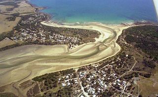
Sorell is a town in Tasmania, Australia, north-east of Hobart. It is located on the Tasman Highway at the junction with the Arthur Highway. Sorell is one of Tasmania's oldest towns, being first settled in 1808 as a small farming community and becoming an official township in 1821. At the 2006 census, Sorell had a population of 1,546, and at the 2011 census, a population of 2,476. and at the 2016 census, a population of 2,907.

Longford is a town in the northern midlands of Tasmania, Australia. It lies 145 m above sea level at the convergence of the Macquarie River and the South Esk River, 21 km south of Launceston and a 15-minute drive from the airport. It is just south of the Illawarra Road, a road connecting the Bass and Midland Highways. It has a population of 3,863 and is part of the Northern Midlands Council area. The region is predominantly agricultural, noted for wool, dairy produce and stock breeding.

Penguin is a town on the north coast of Tasmania, Australia. It is in the Central Coast Council local government area and on the Bass Highway, between Burnie and Ulverstone. At the 2021 census, Penguin had a population of 4,132.

Wynyard (/ˈwɪnjɚd/) wi-nyuhd) is a rural town located on the North West coast of Tasmania, Australia. Wynyard is situated 17 kilometres (11 mi) west of Burnie. As of the 2021 census, Wynyard has an estimated population of 6,296. The town is a regional hub servicing the surrounding rural areas. The main council offices for the Waratah-Wynyard local government area are located in Wynyard.
Pontville is a rural locality in the local government areas (LGA) of Brighton and Southern Midlands in the Hobart and Central LGA regions of Tasmania. The locality is about 4 kilometres (2.5 mi) north-west of the town of Brighton. The 2016 census has a population of 623 for the state suburb of Pontville.
Saltwater River is a rural locality in the local government area (LGA) of Tasman in the South-east LGA region of Tasmania. The locality is about 14 kilometres (8.7 mi) north of the town of Nubeena. The 2016 census has a population of 123 for the state suburb of Saltwater River.

Avoca is a rural locality in the local government areas (LGA) of Northern Midlands (99%) and Break O'Day (1%) in the Central and North-east LGA regions of Tasmania. The locality is about 69 kilometres (43 mi) south-east of the town of Longford. The 2021 census recorded a population of 192 for Avoca.
Weymouth is a rural locality in the local government area (LGA) of George Town in the Launceston LGA region of Tasmania. The locality is about 37 kilometres (23 mi) north-east of the town of George Town. The 2016 census has a population of 129 for the state suburb of Weymouth. It is a small township in northern Tasmania, on the Pipers River opposite Bellingham and about 60 km from Launceston. It has a very small permanent population; however, it attracts many visitors during the summer months. Weymouth has a beach, a tennis court, and a community hall with a playground.
Tyenna is a rural locality in the local government area (LGA) of Derwent Valley in the South-east LGA region of Tasmania. The locality is about 44 kilometres (27 mi) west of the town of New Norfolk. The 2016 census recorded a population of 43 for the state suburb of Tyenna. It is a settlement on the Tyenna River in Tasmania, located 81 kilometres (50 mi) west of the state capital, Hobart and is currently but a remnant of a once thriving rural community.

Mole Creek is a town in the upper Mersey Valley, in the central north of Tasmania, Australia. Mole Creek is well known for its honey and accounts for about 35 percent of Tasmania's honey production. The locality is in the Meander Valley Council area, but with about 3% in the Kentish Council LGA.
Upper Castra is a semi-rural locality in the local government area (LGA) of Central Coast in the North-west and west LGA region of Tasmania. The locality is about 23 kilometres (14 mi) south of the town of Ulverstone. The 2021 census has a population of 85 for Upper Castra.
Tullah is a town in the northern part of the West Coast Range, on the west coast of Tasmania, Australia, about 111 km south of Burnie. The town has a population of approximately 202 people.
Barnes Bay is a rural locality on Bruny Island in the local government area (LGA) of Kingborough in the Hobart LGA region of Tasmania. The locality is about 35 kilometres (22 mi) south of the town of Kingston. The 2016 census recorded a population of 22 for the state suburb of Barnes Bay.
Ouse is a small town in the Central Highlands local government area of Tasmania, Australia, on the Lyell Highway. At the 2016 census, Ouse had a population of 303.

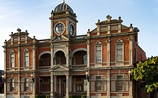
Queenstown Post Office is a heritage-listed post office at 32-34 Orr Street, Queenstown, Tasmania, Australia. It was designed by the Tasmanian government's Public Works Office and built in 1902, with the tower added in 1909. It was added to the Australian Commonwealth Heritage List on 22 June 2004.

North Hobart Post Office is a heritage-listed post office at 412-414 Elizabeth Street, North Hobart, Tasmania, Australia. It was added to the Australian Commonwealth Heritage List on 8 November 2011.
