
The South-east Tasmania Important Bird Area encompasses much of the land retaining forest and woodland habitats, suitable for breeding swift parrots and forty-spotted pardalotes, from Orford to Recherche Bay in south-eastern Tasmania, Australia.
The South-east Tasmania Important Bird Area encompasses much of the land retaining forest and woodland habitats, suitable for breeding swift parrots and forty-spotted pardalotes, from Orford to Recherche Bay in south-eastern Tasmania, Australia.
This large 335,777-hectare (829,720-acre) Important Bird Area (IBA) comprises wet and dry eucalypt forests containing old growth Tasmanian blue gums or black gums, and grassy manna gum woodlands, as well as suburban residential centres and farmland where they retain large flowering, and adjacent hollow-bearing, trees. Key tracts of forest within the IBA include Wielangta, the Meehan and Wellington Ranges, and the Tasman Peninsula. [1]
The area has been identified by BirdLife International as an IBA because it contains almost all the breeding habitat of the endangered swift parrot on the Tasmanian mainland, several populations of the endangered forty-spotted pardalote, as well as good numbers of flame and pink robins, striated fieldwrens and populations of all of Tasmania's endemic bird species. [2]

The South Bruny National Park is a national park located on Bruny Island, Tasmania, Australia, about 50 kilometres (31 mi) south of Hobart. The park contains the Cape Bruny Lighthouse. The highest point of the park is Mount Bruny at 504 metres (1,654 ft).

The Tasman National Park is a national park in eastern Tasmania, Australia, approximately 56 kilometres (35 mi) east of Hobart. The 107.5-square-kilometre (41.5 sq mi) park is situated on part of both the Forestier and Tasman peninsulas and encompasses all of Tasman Island.

Pardalotes are a family, Pardalotidae, of very small, brightly coloured birds native to Australia, with short tails, strong legs, and stubby blunt beaks. This family is composed of four species in one genus, Pardalotus, and several subspecies. The name derives from a Greek word meaning "spotted". The family once contained several other species now split into the family Acanthizidae.
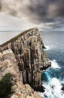
The Tasman Peninsula, officially Turrakana / Tasman Peninsula, is a peninsula located in south-east Tasmania, Australia, approximately 75 km (47 mi) by the Arthur Highway, south-east of Hobart.

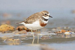
The forty-spotted pardalote is one of Australia's rarest birds and by far the rarest pardalote, being confined to a few colonies in the south-east corner of Tasmania, mainly on Maria Island and Bruny Island.
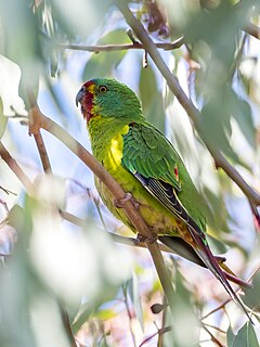
The swift parrot is a species of broad-tailed parrot, found only in southeastern Australia. The species breeds in Tasmania during the summer and migrates north to south eastern mainland Australia from Griffith-Warialda in New South Wales and west to Adelaide in the winter. It is a nomadic migrant, and it settles in an area only when there is food available.
The Meehan Range is a prominent geographical feature of steep hills running parallel to the River Derwent on Hobart's eastern shore. It is located in the City of Clarence, Tasmania. It is a protected area, and is often enjoyed for recreational activities including an expanding network of mountain bike trails.

The Wellington Range is a mountain range located in the southeast region of Tasmania, Australia. The range is mainly composed of dolerite and features evidence of past glaciation.

The Wielangta forest is in south-east Tasmania, Australia. It is notable for its role in a 2006 court case that called into question the effectiveness of Australia's cooperative Commonwealth-State forest management regime known as Regional Forest Agreements.

The Tasmanian masked owl is a bird in the barn owl family Tytonidae that is endemic to the island state of Tasmania, Australia. It is the largest subspecies of the Australian masked owl, the largest Tyto owl in the world, and is sometimes considered a full species. The subspecific name castanops, meaning "chestnut-faced", comes from the colouring of the facial disc. It was first described by John Gould, who wrote about it in his Handbook to the Birds of Australia as:
"…a species distinguished from all the other members of its genus by its great size and powerful form. Probably few of the Raptorial birds, with the exception of the Eagles, are more formidable or more sanguinary in disposition."
"Forests of large but thinly scattered trees, skirting plains and open districts, constitute its natural habitat. Strictly nocturnal in its habits, as night approaches it sallies forth from the hollows of the large gum-trees, and flaps slowly and noiselessly over the plains and swamps in search of its prey, which consists of rats and small quadrupeds generally."
Livingstone is a national park and state conservation area located 30 kilometres (19 mi) south of Wagga Wagga and 10 kilometres (6.2 mi) east of Mangoplah, in the South West Slopes region of south western New South Wales.

The Egg Islands are a small group of low-lying estuarine islands in the tidal lower reaches of the Huon River of south-east Tasmania, Australia. They face the town of Franklin which lies on the western bank of the river.

The Melaleuca to Birchs Inlet Important Bird Area comprises a 2315 km2 section of coast and sub-coastal land in South West Tasmania. It stretches southward from the southern end of Birchs Inlet, encompasses Melaleuca and Port Davey, and extends to Louisa Bay on the coast facing the Maatsuyker Island group. The area is rugged, with extensive beaches and coastal plains rising to rocky mountains. It contains a mosaic of temperate rainforest, eucalypt forest, moorland and buttongrass plains.

The North-west Tasmanian Coast Important Bird Area comprises a 2438 km2 stretch of coastal and subcoastal land covering the northern section of the coast of western Tasmania, south-eastern Australia.

The Richmond Woodlands comprise some 329 km2 of eucalypt woodland remnants close to Richmond, New South Wales, Australia. They lie at the foot of the Blue Mountains on the north-western fringe of the Sydney metropolitan area.
The Robbins Passage and Boullanger Bay Important Bird Area is a 238 km2 tract of land at the western end of the north coast of Tasmania, south-eastern Australia. It comprises extensive areas of intertidal mudflats and saltmarsh with adjacent farmland. It is an important site for waders, or shorebirds.

The Rushworth Box-Ironbark Region is a 510 km2 fragmented and irregularly shaped tract of land that encompasses all the box–ironbark forest and woodland remnants used as winter feeding habitat by endangered swift parrots in the Rushworth-Heathcote region of central Victoria, south-eastern Australia. It lies north of, and partly adjacent to, the Puckapunyal Important Bird Area (IBA).
The Bendigo Box-Ironbark Region is a 505 km2 fragmented and irregularly shaped tract of land that encompasses all the box-ironbark forest and woodland remnants used as winter feeding habitat by swift parrots in the Bendigo-Maldon region of central Victoria, south-eastern Australia.

The Traprock Important Bird Area comprises a 627 km2 tract of land in the Darling Downs region of south-eastern Queensland, Australia.
The Warby–Chiltern Box–Ironbark Region comprises a cluster of separate blocks of remnant box-ironbark forest habitat, with a collective area of 253 km2, in north eastern Victoria, south-eastern Australia.
Southern region of Tasmania, Australia | |||||
|---|---|---|---|---|---|
| City Other settlements | |||||
| Governance | |||||
| Mountains | |||||
| Protected areas, parks and reserves | |||||
| Rivers | |||||
| Harbours, bays, inlets and estuaries | |||||
| Coastal features | |||||
| Transport | |||||
| Landmarks |
| ||||
| Islands | |||||
| Books and newspapers | |||||
| Flora, fauna, and fishlife | |||||
| Bioregions | |||||
| Indigenous heritage | |||||
| Other | |||||
Coordinates: 42°59′35″S147°25′56″E / 42.99306°S 147.43222°E
| | This Tasmania geography article is a stub. You can help Wikipedia by expanding it. |