
Hobart is the capital and most populous city of the Australian island state of Tasmania. Home to almost half of all Tasmanians, it is the least-populated Australian state capital city, and second-smallest if territories are taken into account, before Darwin, Northern Territory. Hobart is located in Tasmania's south-east on the estuary of the River Derwent, making it the most southern of Australia's capital cities. Its skyline is dominated by the 1,271-metre (4,170 ft) kunanyi/Mount Wellington, and its harbour forms the second-deepest natural port in the world, with much of the city's waterfront consisting of reclaimed land. The metropolitan area is often referred to as Greater Hobart, to differentiate it from the City of Hobart, one of the five local government areas that cover the city. It has a mild maritime climate.

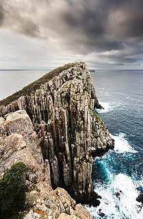
The Tasman National Park is a national park in eastern Tasmania, Australia, approximately 56 kilometres (35 mi) east of Hobart. The 107.5-square-kilometre (41.5 sq mi) park is situated on part of both the Forestier and Tasman peninsulas and encompasses all of Tasman Island.
The Tasman Peninsula, officially Turrakana / Tasman Peninsula, is a peninsula located in south-east Tasmania, Australia, approximately 75 km (47 mi) by the Arthur Highway, south-east of Hobart.

Clarence City Council is a local government body in Tasmania, and one of the five municipalities that constitutes the Greater Hobart Area. The Clarence local government area has a population of 56,945, covering the eastern shore of the Derwent River from Otago to the South Arm Peninsula and the smaller localities of Cambridge, Richmond, and Seven Mile Beach.

Bellerive Oval, known commercially as Blundstone Arena for sponsorship reasons, is a cricket and Australian rules football ground located in Bellerive, a suburb on the eastern shore of Hobart, Australia, holding 20,000 people - the second largest capacity stadium in Tasmania. It is the only venue in Tasmania which hosts international Cricket matches.

The Tasman Highway is a highway in Tasmania, Australia. Like the Midland Highway, it connects the major cities of Hobart and Launceston – however it takes a different route, via the north-eastern and eastern coasts of the state. The Highway also acts as a major commuter road to Hobart residents living on the eastern side of the Derwent River. The designation "Tasman Highway" arises from its location facing the Tasman Sea – named, like the state itself, after Abel Tasman. The highway is one of the longest in Tasmania - 410 km (250 mi), with an average traveling time of 41⁄2 hours.
Howrah is a residential locality in the local government area (LGA) of Clarence in the Hobart LGA region of Tasmania. The locality is about 5 kilometres (3.1 mi) south-east of the town of Rosny Park. The 2016 census recorded a population of 8690 for the state suburb of Howrah. It is a suburb of the City of Clarence. It is east of Bellerive and north of Tranmere.

De Witt Island, also known as Big Witch, is an island located close to the south-western coast of Tasmania, Australia. The 516-hectare (1.99 sq mi) island is the largest of the Maatsuyker Islands Group, and comprises part of the Southwest National Park and the Tasmanian Wilderness World Heritage Site. The island is listed on the Australian Register of the National Estate.

The Coal River Valley is located in the City of Clarence, Tasmania and is a primarily agrarian area to the east of the city, located between the townships of Cambridge and Colebrook. With the historic town of Richmond at its heart, it is nestled between the Meehan Range and the Pontos Range.

Warrane is a suburb of Hobart, Tasmania, Australia, within the City of Clarence local government area. It is approximately 5 kilometres (3 mi) from Hobart's CBD. It is located between Rosny Park and Mornington and runs parallel to the Tasman Highway.
Mount Rumney is a semi-rural locality in the local government area (LGA) of Clarence in the Hobart LGA region of Tasmania. The locality is about 7 kilometres (4.3 mi) east of the town of Rosny Park. The 2016 census has a population of 267 for the state suburb of Mount Rumney. It is a suburb of Hobart.
Ralphs Bay is a body of water in south-east Tasmania, Australia. It is semi-enclosed by the Tranmere / Rokeby peninsula and the South Arm peninsula. Sea access to the bay is from the River Derwent.
Acton Park is a residential / rural locality in the local government area (LGA) of Clarence in the Hobart LGA region of Tasmania. The locality is about 15 kilometres (9.3 mi) east of the town of Rosny Park. The 2021 census recorded a population of 2293 for Acton Park.

The Wielangta forest is in south-east Tasmania, Australia. It is notable for its role in a 2006 court case that called into question the effectiveness of Australia's cooperative Commonwealth-State forest management regime known as Regional Forest Agreements.
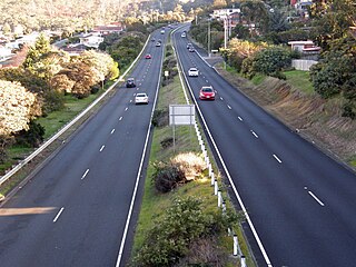
The South Arm Highway is a highway serving the southern suburbs of Hobart, on the eastern shore of the River Derwent in Tasmania, Australia. The highway is a major trunk road that carries heavy commuter traffic south from the Eastern Outlet to Howrah and Rokeby. As one of the Tasman Highway's principle Feeders and one of the eastern shore's major transport corridors, The South Arm Highway facilitates the movement of traffic between the suburbs and satellite communities to the south with the city centre and ultimately, other major cross city highways. With annual average daily traffic (AADT) of 17,000, the highway is considered a major traffic corridor within Hobart. The designation "South Arm Highway" arises from its journey south to South Arm.

Flat Top Island is an island located close to the south-western coast of Tasmania, Australia. The 1.58-hectare (0.0061 sq mi) island is part of the Maatsuyker Islands Group, and comprises part of the Southwest National Park and the Tasmanian Wilderness World Heritage Site.

South East Mutton Bird Islet is a steep unpopulated islet located close to the south-western coast of Tasmania, Australia. Situated 2 kilometres (1.2 mi) south of where the mouth of Port Davey meets the Southern Ocean, the 0.52-hectare (1.3-acre) islet is one of the eight islands that comprise the Mutton Bird Islands Group. The South East Mutton Bird Islet is part of the Southwest National Park and the Tasmanian Wilderness World Heritage Site.
The East Pyramids comprise a group of three steep, rocky unpopulated islets located close to the south-western coast of Tasmania, Australia. Situated some 2 kilometres (1.2 mi) south of where the mouth of Port Davey meets the Southern Ocean, the 6.69-hectare (16.5-acre) islets are one of the eight islands that comprise the Mutton Bird Islands Group. The East Pyramids are part of the Southwest National Park and the Tasmanian Wilderness World Heritage Site.
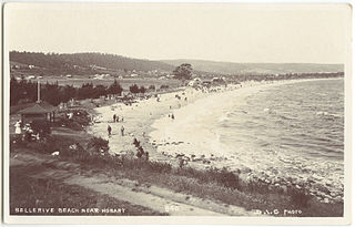
Bellerive Beach is a popular beach destination along the River Derwent in Bellerive, Hobart, Tasmania. The south facing beach neighbours the historic Kangaroo Battery coastal defences and has views of the Derwent estuary, Howrah, Tranmere and Sandy Bay on the western shore. Bellerive Beach has an adjoining parkland with play equipment, barbecues and bathroom facilities and is backed by the Bellerive Oval, a narrow tree-lined reserve and private properties.

