Derwent Valley, Tasmania

Last updated

Derwent Valley
Valley of Love [1]
Derwent Valley from the highway 2009.jpg
Derwent Valley vistas from the Lyell Highway, 2009
Relief Map of Tasmania.png
Red pog.svg
Derwent Valley
Location of the Derwent Valley in Tasmania
Area4,111 km2 (1,587 sq mi) [1]
Geography
Location Tasmania, Australia
Population centers New Norfolk, Bushy Park, Maydena and Strathgordon
Coordinates 42°48′11.17″S146°32′38.55″E / 42.8031028°S 146.5440417°E / -42.8031028; 146.5440417
Rivers River Derwent, Plenty River

The Derwent Valley is a river valley and geographic area located in southern Tasmania, Australia. The largest town is New Norfolk, with other smaller towns spread across the area. The Derwent Valley area had a population of 10,942 in 2021. [2] Commencing at Lake St Clair and spanning 239 kilometres (149 mi) to the state capital of Hobart, the River Derwent receives contributions from numerous tributaries and plays a role in Tasmania's intricate hydroelectric system at certain points. Renowned for its agricultural output, the Derwent Valley was initially settled by British colonists during the 1800s. Prior to colonisation, the area was inhabited by the Leenowwenne peoples of the Big River district. [3]

Contents

Economy

The economy of the Derwent Valley is diverse, with a blend of agriculture, tourism, small businesses, and local industries contributing to the region's economic activities. [4]

Bushy Park in 2014 Bushy Park Derwent Valley (22659179635).jpg
Bushy Park in 2014

The hop industry in the Derwent Valley has held considerable importance as a primary sector and for many years was the most successful hop growing area in the Southern Hemisphere. [5] Beginning in 1849, the Shoobridge family played a pivotal role in advancing the prosperity and development of hop cultivation in the Derwent Valley. Records indicate the initial mention of hops in Tasmania's agricultural reports in 1854. [6] For an impressive span of 65 years, the Shoobridge family diligently farmed the Bushy Park properties, dedicating the majority of this time to consistent hop production. This sustained effort resulted in Bushy Park becoming renowned as the most prosperous hop-growing region in the southern hemisphere. [7] [8]

The valley is renowned for its fertile soils and favorable climate, making it an ideal area for agriculture. The region produces a variety of agricultural products, including fruits like apples, cherries, berries, and stone fruits, as well as vegetables. [9] Many farms in the Derwent Valley engage in horticulture and orcharding, contributing significantly to Tasmania's agricultural output. [10] There are thriving trout and salmon fish hatcheries, exemplified by the Salmon Ponds, founded in 1864 with the aim of introducing salmon to the region. While the initial salmon introduction didn't succeed as anticipated, focus shifted to trout, also imported from England. This hatchery served as the cornerstone for trout hatcheries across Australia and New Zealand. [11] Presently, the Salmon Ponds continue to supply trout stock for Tasmania's lakes and rivers. [12]

The picturesque landscapes and historical significance of the Derwent Valley attract tourists. Visitors are drawn to the region's natural beauty, heritage sites, and outdoor recreational activities. Tourism-related businesses such as accommodations, restaurants, local markets, and adventure tourism activities play a role in the local economy. The Derwent Valley hosts Mount Field National Park, among Australia's oldest preserved natural landscapes. This park shelters distinctive Tasmanian wildlife and plants, including rare native species and some of the globe's tallest trees. It boasts lakes, snow-covered peaks in winter, and breathtaking waterfalls like Lady Barron Falls, Horseshoe Falls, and Russell Falls. Visitors can engage in various activities such as hiking, nocturnal glow worm tours, [13] skiing, spelunking, and camping within the park's bounds. [4]

Historically, the Derwent Valley has been involved in forestry and timber-related activities. While this sector has undergone changes over the years, forestry remains a part of the region's economy. [14]

Employment opportunities in the Derwent Valley encompass a range of sectors, including agriculture, tourism, retail, healthcare, education, and public services. Local services such as healthcare facilities, schools, and community services also contribute to the economic and social well-being of the region.[ citation needed ]

History

The area was first settled by Europeans in the early 1800s. The Derwent Valley Railway opened on the 1 September 1887. [15]

Media

The Derwent Valley hosts The Derwent Valley Gazette, a weekly local newspaper, and the New Norfolk and Derwent Valley News, an online new resource. Edge Radio is the local youth radio station and New Norfolk is the headquarters of TYGA FM, a community radio station.[ citation needed ]

See also

Related Research Articles

<span class="mw-page-title-main">Hobart</span> Capital city of Tasmania, Australia

Hobart is the capital and most populous city of the island state of Tasmania, Australia. Home to almost half of all Tasmanians, it is the southernmost and least-populated Australian state capital city, and second-smallest if territories are taken into account, before Darwin, Northern Territory. Hobart is located in Tasmania's south-east on the estuary of the River Derwent, making it the most southern of Australia's capital cities. Its skyline is dominated by the 1,271-metre (4,170 ft) kunanyi/Mount Wellington, and its harbour forms the second-deepest natural port in the world, with much of the city's waterfront consisting of reclaimed land. The metropolitan area is often referred to as Greater Hobart, to differentiate it from the City of Hobart, one of the seven local government areas that cover the city. It has a mild maritime climate.

Councils of Tasmania are the 29 administrative districts of the Australian state of Tasmania. Local government areas (LGAs), more generally known as councils, are the tier of government responsible for the management of local duties such as road maintenance, town planning and waste management.

<span class="mw-page-title-main">River Derwent (Tasmania)</span> River in south east Tasmania, Australia

The River Derwent is a river located in Tasmania, Australia. It is also known by the palawa kani name timtumili minanya. The river rises in the state's Central Highlands at Lake St Clair, and descends more than 700 metres (2,300 ft) over a distance of more than 200 kilometres (120 mi), flowing through Hobart, the state's capital city, before emptying into Storm Bay and flowing into the Tasman Sea. The banks of the Derwent were once covered by forests and occupied by Aboriginal Tasmanians. European settlers farmed the area and during the 20th century many dams were built on its tributaries for the generation of hydro-electricity.

<span class="mw-page-title-main">City of Clarence</span> Local government area in Tasmania, Australia

Clarence City Council is a local government body in Tasmania, and one of the five municipalities that constitutes the Greater Hobart Area. The Clarence local government area has a population of 61,531, covering the eastern shore of the Derwent River from Otago to the South Arm Peninsula and the smaller localities of Cambridge, Richmond, and Seven Mile Beach.

<span class="mw-page-title-main">Derwent Valley Council</span> Local government area in Tasmania, Australia

Derwent Valley Council is a local government body situated in southern-central Tasmania, west of Hobart. Derwent Valley is classified as a rural local government area and has a population of 10,290, it includes the localities of Bushy Park, Maydena and Strathgordon, with New Norfolk the major, principal town.

<span class="mw-page-title-main">Central Highlands Council</span> Local government area in Tasmania, Australia

Central Highlands Council is a local government body in Tasmania, encompassing the Central Highlands region of the state. Central Highlands is classified as a rural local government area and has a population of 2,144, the two largest towns are Bothwell and Hamilton.

<span class="mw-page-title-main">New Norfolk</span> Town in Tasmania, Australia

New Norfolk is a town on the River Derwent, in the south-east of Tasmania, Australia. With a population of 6,153 in 2021, New Norfolk is the principal township of the Derwent Valley region. Located within the Derwent Valley Council, New Norfolk is situated 32 kilometres (20 mi) north-west of the state capital Hobart on the Lyell Highway and classified as part of the Greater Hobart statistical area.

<span class="mw-page-title-main">Rainbow trout</span> Fresh-water species of fish

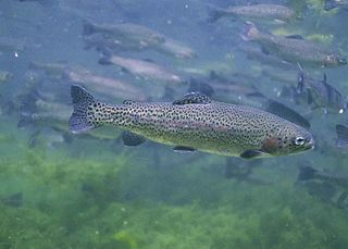
The rainbow trout is a species of trout native to cold-water tributaries of the Pacific Ocean in Asia and North America. The steelhead is an anadromous (sea-run) form of the coastal rainbow trout(O. m. irideus) or Columbia River redband trout (O. m. gairdneri) that usually returns to freshwater to spawn after living two to three years in the ocean. Freshwater forms that have been introduced into the Great Lakes and migrate into tributaries to spawn are also called steelhead.

<span class="mw-page-title-main">Jindabyne, New South Wales</span> Town in New South Wales, Australia

Jindabyne is a town in south-east New South Wales, Australia that overlooks Lake Jindabyne near the Snowy Mountains, in Snowy Monaro Regional Council. It is a popular holiday destination year round, especially in winter. This is due to its proximity to major ski resort developments within the Kosciuszko National Park, including Thredbo, Perisher and Charlotte Pass.

<span class="mw-page-title-main">Central Highlands (Tasmania)</span> Region in Australia

The Central Highlands is a region in Tasmania, Australia where geographical and administrative boundaries closely coincide. It is also known as The Lake Country of Tasmania.

<span class="mw-page-title-main">Huon Valley</span> Valley in Tasmania, Australia

The Huon Valley, or simply the Huon, is a valley and geographic area located in southern Tasmania, Australia. The largest town is Huonville, with other smaller towns spread across the area. It includes Australia's most southern permanent settlement at Southport. The Huon Valley Council area had a population of 15,140 in 2011. Famed for its apple growing, the Valley was first settled by British colonists in the 1820s; prior to settlement the Huon Valley area was inhabited by the Mouheneenner, Nuenonne, Mellukerdee and Lyluequonny people.

<span class="mw-page-title-main">South West Tasmania</span> Region in Tasmania, Australia

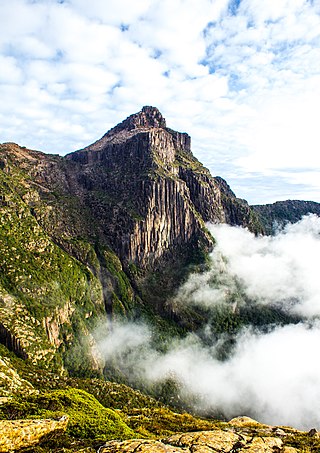
South West Tasmania is a region in Tasmania that has evoked curiosity as to its resources over the duration of European presence on the island.

Plenty is a rural locality in the local government area (LGA) of Derwent Valley in the South-east LGA region of Tasmania. The locality is about 9 kilometres (5.6 mi) north-west of the town of New Norfolk. The 2016 census recorded a population of 93 for the state suburb of Plenty. It is a small locality and the name of a tributary river on the south side of the River Derwent in the Derwent Valley.

<span class="mw-page-title-main">Magra, Tasmania</span> Town in Tasmania, Australia

Magra is a rural residential locality in the local government areas (LGA) of Brighton (7%), Southern Midlands (9%) and Derwent Valley (84%) in the Hobart, Central and South-east LGA regions of Tasmania. The locality is about 26 kilometres (16 mi) west of the town of Brighton. The 2016 census recorded a population of 699 for the state suburb of Magra. It is in the Derwent Valley a few kilometres north of New Norfolk.

<span class="mw-page-title-main">Aquaculture in Australia</span>

Aquaculture in Australia is the country's fastest-growing primary industry, accounting for 34% of the total gross value of production of seafood. 10 species of fish are farmed in Australia, and production is dominated by southern bluefin tuna, Atlantic salmon and barramundi. Mud crabs have also been cultivated in Australia for many years, sometimes leading to over-exploitation. Traditionally, this aquaculture was limited to table oysters and pearls, but since the early 1970s, there has been significant research and commercial development of other forms of aquaculture, including finfish, crustaceans, and molluscs.

Louis Manton Shoobridge Sr. was an Australian politician. He was born in New Norfolk, Van Diemen's Land. He unsuccessfully contested the 1914 Senate election as a Liberal candidate  and the 1919 election for the federal seat of Franklin as a Nationalist candidate. In 1921 he was elected to the Tasmanian Legislative Council as the Independent member for Derwent, serving until his retirement in 1937. His father Ebenezer Shoobridge, brother William Shoobridge, son Rupert Shoobridge and grandson Louis Shoobridge Jr. were all members of the Tasmanian Parliament.

<span class="mw-page-title-main">Ebenezer Shoobridge</span> Australian politician

Ebenezer Shoobridge (1820–1901) was an Australian politician. He represented the Electoral district of New Norfolk in the Tasmanian House of Assembly from the 1882 election until he was defeated at the 1886 election.

Bushy Park is a rural locality and town in the local government area of Derwent Valley in the South-east region of Tasmania. It is located about 19 kilometres (12 mi) north-west of the town of New Norfolk. The 2016 census determined a population of 126 for the state suburb of Bushy Park.

Glenfern is a rural locality in the local government area (LGA) of Derwent Valley in the South-east LGA region of Tasmania. The locality is about 10 kilometres (6.2 mi) south-west of the town of New Norfolk. The 2016 census recorded a population of 189 for the state suburb of Glenfern.

Lawitta is a rural locality in the local government area (LGA) of Derwent Valley in the South-east LGA region of Tasmania. The locality is about 4 kilometres (2.5 mi) north-west of the town of New Norfolk. The 2016 census recorded a population of 232 for the state suburb of Lawitta.

References

  1. 1 2 "Derwent Valley". Great Australian Secret. Archived from the original on 5 December 2022. Retrieved 2 January 2024.
  2. "2021 Census QuickStats - Derwent Valley (M)". censusdata.abs.gov.au. Australian Bureau of Statistics. Retrieved 2 January 2024.
  3. "Willow Court Precinct Heritage Interpretation Plan" (PDF). Derwent Valley Council . p. 3. Retrieved 2 January 2024.
  4. 1 2 Derwent Valley Council 2020, p. 19.
  5. "DERWENT VALLEY". Huon And Derwent Times . Vol. 25, no. 2422. Tasmania, Australia. 28 February 1935. p. 4. Retrieved 2 January 2024 via National Library of Australia.
  6. Bushy Park Estate (1871), Farm records , retrieved 3 January 2024
  7. Weidenhofer, Maggie (1983), "Bushy Park: Derwent Valley hop farm", This Australia, 2 (3): 39–43, retrieved 3 January 2024
  8. Miller, CL (1 January 1980), Structural adjustment and regional relocation in the Tasmanian hop industry , retrieved 3 January 2024
  9. Derwent Valley Council 2020, p. 20.
  10. "Derwent Valley Council area - Industry sector of employment". Informed Decisions. Retrieved 9 March 2024.
  11. "Salmon-breeding Ponds, New Norfolk, Tasmania". The Australasian . Vol. LXXV, no. 1951. Victoria, Australia. 22 August 1903. p. 27. Retrieved 9 March 2024 via National Library of Australia.
  12. "Stocking database". Inland Fisheries Service. Retrieved 9 March 2024.
  13. Derwent Valley Council 2018, p. 21.
  14. "Broad support for new forestry venture centred in New Norfolk". New Norfolk and Derwent Valley News. 20 October 2020. Retrieved 2 January 2024.
  15. "Opening of the Derwent Valley Railway". The Mercury (Hobart) . Vol. LI, no. 5, 472. Tasmania, Australia. 2 September 1887. p. 3. Retrieved 2 January 2024 via National Library of Australia.

Sources