Van Diemen's Land was the colonial name of the island of Tasmania used by the British during the European exploration and colonisation of Australia in the 19th century. The island was previously discovered and named by the Dutch in 1642. Explorer Abel Tasman discovered the island, working under the sponsorship of Anthony van Diemen, the Governor-General of the Dutch East Indies. The British retained the name when they established a settlement in 1803 before it became a separate colony in 1825. Its penal colonies became notorious destinations for the transportation of convicts due to the harsh environment, isolation and reputation for being inescapable.

The Tasman National Park is a national park in eastern Tasmania, Australia, approximately 56 kilometres (35 mi) east of Hobart. The 107.5-square-kilometre (41.5 sq mi) park is situated on part of both the Forestier and Tasman peninsulas and encompasses all of Tasman Island.

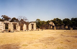
Port Arthur is a town and former convict settlement on the Tasman Peninsula, in Tasmania, Australia. It is located approximately 97 kilometres (60 mi) southeast of the state capital, Hobart.

The Tasman Peninsula, officially Turrakana / Tasman Peninsula, is a peninsula located in south-east Tasmania, Australia, approximately 75 km (47 mi) by the Arthur Highway, south-east of Hobart.
Tasman Council is a local government body in Tasmania, situated in the south-east of the state. Tasman is classified as a rural local government area and has a population of 2,404, the region covers both the Tasman and Forestier peninsulas, with Nubeena the principal town.

The Forestier Peninsula is a peninsula located in south-east Tasmania, Australia, approximately 60 kilometres (37 mi) by the Arthur Highway, south-east of Hobart. The peninsula is connected to mainland Tasmania at East Bay Neck, near the town of Dunalley at its northern end. At Eaglehawk Neck, the southern end of the Forestier Peninsula is connected to the Tasman Peninsula.
Saltwater River is a rural locality in the local government area (LGA) of Tasman in the South-east LGA region of Tasmania. The locality is about 14 kilometres (8.7 mi) north of the town of Nubeena. The 2016 census has a population of 123 for the state suburb of Saltwater River.
Eaglehawk is another name for the wedge-tailed eagle.
The Arthur Highway (A9) is a Tasmanian highway which runs from Sorell in the near south to Port Arthur in the far south-east.
Taranna is a rural locality in the local government area (LGA) of Tasman in the South-east LGA region of Tasmania. The locality is about 16 kilometres (9.9 mi) north-east of the town of Nubeena. The 2016 census recorded a population of 156 for the state suburb of Taranna. It is a hamlet on the Tasman Peninsula. Local points of interest include its Presbyterian church, immediately adjacent to the Federation Chocolate Factory, and a Tasmanian Devil park, "Unzoo".

In geology and geomorphology, a tessellated pavement is a relatively flat rock surface that is subdivided into polygons by fractures, frequently systematic joints, within the rock. This type of rock pavement bears this name because it is fractured into polygonal blocks that resemble tiles of a mosaic floor, or tessellations.
Murdunna is a rural locality in the local government area (LGA) of Tasman in the South-east LGA region of Tasmania. The locality is about 36 kilometres (22 mi) north-east of the town of Nubeena. The 2016 census recorded a population of 309 for the state suburb of Murdunna. It is a small town at the head of King George Sound, a narrow bay opening off Norfolk Bay. Murdunna is approximately halfway down the Forestier Peninsula on the Arthur Highway to Port Arthur. It is around 6 metres above sea level.
Pennicott Wilderness Journeys is a tourism company based in Hobart, Tasmania. It operates two separate tours, one on Bruny Island and one at Port Arthur. The company was founded as Bruny Island Charters in 1999 by Robert Pennicott and is one of the largest tourism operators in Tasmania, carrying 50,000 passengers over the 2009/10 season.
Dunalley is a rural / residential locality in the local government areas (LGA) of Sorell (37%) and Tasman (63%) in the South-east LGA region of Tasmania. The locality is about 31 kilometres (19 mi) south-east of the town of Sorell. The 2021 census recorded a population of 304 for the state suburb of Dunalley. It is a small fishing village on the east coast of Tasmania.

Koonya is a rural locality in the local government area (LGA) of Tasman in the South-east LGA region of Tasmania. The locality is about 18 kilometres (11 mi) north-east of the town of Nubeena. The 2016 census has a population of 134 for the state suburb of Koonya. It hosts the annual Koonya Garlic Festival, a "one-day celebration".
The Norfolk Bay is a body of water in the south east of Tasmania, Australia. The north west aspect of Norfolk Bay is continuous with Frederick Henry Bay. The north east aspect of Norfolk Bay is continuous with Blackman Bay via the Denison Canal.

Charles O'Hara Booth, was an English-born army officer who served in India, the West Indies and England for a total of 18 years before being posted to Van Diemen's Land, Australia. He remained there for a further 18 years, first as commandant of Port Arthur penal settlement and subsequently as the head of an orphan's school.

The Convict Tramway was hauled by human power: convicts from the Port Arthur convict settlement. and was created to replace the hazardous sea voyage from Hobart to Port Arthur, Tasmania. Charles O'Hara Booth oversaw the construction of the tramway.

Isle of the Dead is an island, about 1 hectare in area, adjacent to Port Arthur, Tasmania, Australia. It is historically significant since it retains an Aboriginal coastal shell midden, one of the first recorded sea-level benchmarks, and one of the few preserved Australian convict-period burial grounds. The Isle of the Dead occupies part of the Port Arthur Historic Site, is part of Australian Convict Sites and is listed as a World Heritage Property because it represents convictism in the era of British colonisation.

William Bannon was an Irishman who served in the British 65th Regiment of Foot in the New Zealand Wars in the 1840s. In 1849 he was found guilty of desertion and theft and was sentenced to transportation for seven years to Van Diemen's Land. A reward was posted for Bannon's capture after he escaped from a prison in Van Diemen's Land and, following his capture, he was transported to Norfolk Island before returning to Australia. "Murdering Gully Rd" at Table Cape, Tasmania is named after a murder that Bannon was accused of committing in 1858.
 Tessellated Pavement at sunrise
 Pirates Bay and Doo Town
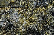 Hormosira growing on the Tesselated pavement at Eaglehawk Neck
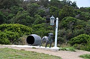 Statue representing the dogline at Eaglehawk Neck


