Van Diemen's Land was the colonial name of the island of Tasmania used by the British during the European exploration of Australia in the 19th century. A British settlement was established in Van Diemen's Land in 1803 before it became a separate colony in 1825. Its penal colonies became notorious destinations for the transportation of convicts due to the harsh environment, isolation and reputation for being inescapable. Macquarie Harbour and Port Arthur are among the most well-known penal settlements on the island.

The maritime European exploration of Australia consisted of several waves of European seafarers who sailed the edges of the Australian continent. Dutch navigators were the first Europeans known to have explored and mapped the Australian coastline. The first documented encounter was that of Dutch navigator Willem Janszoon, in 1606. Dutch seafarers also visited the west and north coasts of the continent, as did French explorers.

Bass Strait is a strait separating the island state of Tasmania from the Australian mainland. The strait provides the most direct waterway between the Great Australian Bight and the Tasman Sea, and is also the only maritime route into the economically prominent Port Phillip Bay.
Councils of Tasmania are the 29 administrative districts of the Australian state of Tasmania. Local government areas (LGAs), more generally known as councils, are the tier of government responsible for the management of local duties such as road maintenance, town planning and waste management.

The River Derwent is a river located in Tasmania, Australia. It is also known by the palawa kani name timtumili minanya. The river rises in the state's Central Highlands at Lake St Clair, and descends more than 700 metres (2,300 ft) over a distance of more than 200 kilometres (120 mi), flowing through Hobart, the state's capital city, before emptying into Storm Bay and flowing into the Tasman Sea. The banks of the Derwent were once covered by forests and occupied by Aboriginal Tasmanians. European settlers farmed the area and during the 20th century many dams were built on its tributaries for the generation of hydro-electricity.

The Tasman Peninsula, officially Turrakana / Tasman Peninsula, is a peninsula located in south-east Tasmania, Australia, approximately 75 km (47 mi) by the Arthur Highway, south-east of Hobart.

Bruny Island is a 362-square-kilometre (140 sq mi) island located off the southeastern coast of Tasmania, Australia. The island is separated from the Tasmanian mainland by the D'Entrecasteaux Channel, and its east coast lies within the Tasman Sea. Located to the island's northeast Storm Bay, is the river mouth to the Derwent River estuary, and serves as the main port of Hobart, Tasmania's capital city. Both the island and the channel are named after French explorer, Antoine Bruni d'Entrecasteaux. Its traditional Aboriginal name is lunawanna-allonah, which survives as the name of two island settlements, Alonnah and Lunawanna.

Tasman Council is a local government body in Tasmania, situated in the south-east of the state. Tasman is classified as a rural local government area and has a population of 2,404, the region covers both the Tasman and Forestier peninsulas, with Nubeena the principal town.

The Forestier Peninsula is a peninsula located in south-east Tasmania, Australia, approximately 60 kilometres (37 mi) by the Arthur Highway, south-east of Hobart. The peninsula is connected to mainland Tasmania at East Bay Neck, near the town of Dunalley at its northern end. At Eaglehawk Neck, the southern end of the Forestier Peninsula is connected to the Tasman Peninsula.
The Arthur Highway (A9) is a Tasmanian highway which runs from Sorell in the near south to Port Arthur in the far south-east.
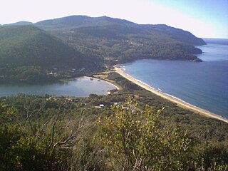
Eaglehawk Neck, officially Teralina / Eaglehawk Neck, is a narrow isthmus that connects the Tasman Peninsula with the Forestier Peninsula and hence to the rest of Tasmania, Australia.

The D'Entrecasteaux Channel is a body of water located between Bruny Island and the south-east of the mainland of Tasmania, Australia. The channel is the mouth for the estuaries of the Derwent and the Huon Rivers and empties into the Tasman Sea of the South Pacific Ocean. It was sighted by Abel Tasman in 1642 and surveyed in 1792 by Bruni d'Entrecasteaux.
Frederick Henry Bay is a body of water in the southeast of Tasmania, Australia. It is located to the east of the South Arm Peninsula, and west of the Tasman Peninsula. Towns on the coast of the bay include Lauderdale, Seven Mile Beach, Dodges Ferry and Primrose Sands. The bay is accessible via Storm Bay from the south, and provides further access to Norfolk Bay to its east.

Sloping Island, incorporating the adjacent Sloping Reef, is an island nature reserve, with an area of 117 ha, in Tasmania in south-eastern Australia. It is part of the Sloping Island Group, lying close to the south-eastern coast of Tasmania around the Tasman and Forestier Peninsulas.

Smooth Island, is a privately owned island with an area of 59.31 ha lying close to the south-eastern coast of Tasmania, Australia. The island is part of the Sloping Island Group situated in Norfolk Bay and surrounded by the Tasman and Forestier Peninsulas. The towns Dunalley and Murdunna are nearby. Smooth Island differs from other Tasmanian islands as it has an unencumbered freehold title down to the high-water mark.

King George Island is an island in south-eastern Australia. It is part of the Sloping Island Group, lying close to the south-eastern coast of Tasmania around the Tasman and Forestier Peninsulas. The island was once inhabited and farmed and contains the ruins of two buildings on its eastern side. A conservation covenant is in place on this island.
Dunalley is a rural / residential locality in the local government areas (LGA) of Sorell (37%) and Tasman (63%) in the South-east LGA region of Tasmania. The locality is about 31 kilometres (19 mi) south-east of the town of Sorell. The 2021 census recorded a population of 304 for the state suburb of Dunalley. It is a small fishing village on the east coast of Tasmania.
Cape Raoul is a rural locality and a natural feature in the local government area of Tasman in the South-east region of Tasmania. It is located about 13 kilometres (8.1 mi) south of the town of Nubeena. The 2016 census determined a population of nil for the state suburb of Cape Raoul.
This article outlines the history of Smooth Island, popularly known as Garden Island, in Norfolk Bay, Tasmania. The names come from the island's gently undulating topography and lush vegetation in comparison with the stony mainland. It has been privately owned since 1864.
Premaydena is a rural locality in the local government area of Tasman in the South-east region of Tasmania. The locality is about 7 kilometres (4.3 mi) north of the town of Nubeena. The 2016 census has a population of 99 for the state suburb of Premaydena.
