The Parliament of Tasmania is the bicameral legislature of the Australian state of Tasmania. It follows a Westminster-derived parliamentary system and consists of the governor of Tasmania, the Tasmanian House of Assembly, and Tasmanian Legislative Council. Since 1841, both Houses have met in Parliament House, Hobart. The Parliament of Tasmania first met in 1856.

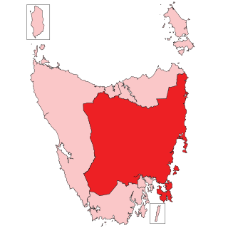
The Division of Lyons is an Australian electoral division in Tasmania.

The Colonial sloop Norfolk was built on Norfolk Island in 1798 of Norfolk Island Pine. She was wrecked in 1800.
The Division of Wilmot was an Australian Electoral Division in the state of Tasmania. It was located in central Tasmania, and was named after Sir John Eardley-Wilmot, the sixth Lieutenant-Governor of Tasmania. At various times it included the towns of Deloraine, Beaconsfield, Devonport, Latrobe, and New Norfolk.

The Royal Hobart Regatta is a series of aquatic competitions and displays held annually in Hobart, Tasmania, Australia and is Tasmania's oldest sporting event. The regatta began in 1838.

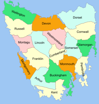
The Lands administrative divisions of Tasmania are the divisions of Tasmania into land districts and parishes for cadastral purposes, which are part of the lands administrative divisions of Australia. There are 20 land districts in Tasmania, although in the early nineteenth century there were several other systems, with 18 or 36 counties and 9 other divisions used, as well as hundreds. The land districts include the 18 former counties of the island of Tasmania which were renamed but retain the same boundaries, plus King Island and Flinders Island. The counties are referenced in the 1911 Encyclopædia Britannica, with Hobart described as being in Buckingham County, Launceston in Cornwall County and Beaconsfield in Devon County. The land districts are used for land titles today, while the Local Government Areas of Tasmania with cities and municipalities are used for political and administrative purposes.

Sloping Island, incorporating the adjacent Sloping Reef, is an island nature reserve, with an area of 117 ha, in Tasmania in south-eastern Australia. It is part of the Sloping Island Group, lying close to the south-eastern coast of Tasmania around the Tasman and Forestier Peninsulas.

Smooth Island, is a privately owned island with an area of 59.31 ha lying close to the south-eastern coast of Tasmania, Australia. The island is part of the Sloping Island Group situated in Norfolk Bay and surrounded by the Tasman and Forestier Peninsulas. The towns Dunalley and Murdunna are nearby. Smooth Island differs from other Tasmanian islands as it has an unencumbered freehold title down to the high-water mark.

King George Island is an island in south-eastern Australia. It is part of the Sloping Island Group, lying close to the south-eastern coast of Tasmania around the Tasman and Forestier Peninsulas. The island was once inhabited and farmed and contains the ruins of two buildings on its eastern side. A conservation covenant is in place on this island.
Garden Island is a small stony island that is part of the Partridge Island Group, lying close to the south-eastern coast of Tasmania, Australia, in the D'Entrecasteaux Channel between Bruny Island and the mainland. The D'Entrecasteaux Channel is the mouth for the Huon River.
The Sloping Island Group is a group of small islands in south-eastern Tasmania in Australia. They lie close to the south-eastern coast of Tasmania around the Tasman and Forestier Peninsulas.
South Arm Peninsula is a peninsula that lies on the east side of the mouth of the River Derwent south of Hobart in Tasmania, Australia. The peninsula commences at Lauderdale and curves landward or inward on a narrow isthmus that has South Arm situated on the east side of the Derwent, across from Blackmans Bay on the west side. Opossum Bay is the northernmost populated place on the northward curve.
The Norfolk Bay is a body of water in the south east of Tasmania, Australia. The north west aspect of Norfolk Bay is continuous with Frederick Henry Bay. The north east aspect of Norfolk Bay is continuous with Blackman Bay via the Denison Canal.
Blackman Bay is located on the south-east coast of Tasmania. It extends from the bay's inlet at the southern peninsula of Marion Bay to the village of Dunalley. Historically this bay was referred to as "Frederick Henry Bay".

The Hope and Anchor Tavern is an Australian pub in Hobart, Tasmania. Built in 1807, it is the oldest continually licensed pub in Australia. However, The Bush Inn in New Norfolk claims to be the oldest operating Australian pub, because their venue has operated continuously since it opened in 1815 whereas the Hope and Anchor Tavern has had periods of closure since opening in 1807. The Hope and Anchor Tavern is referred to in Captain A E Sykes: memoirs.
Flinder's trench is a region within Norfolk Bay, to the south of King George Island (Tasmania), Australia, which used to demarcate the northernmost extent of a region which was rich with mussels and other oceanic invertebrates. This region extended to Smooth Island (Tasmania) and as far south as Taranna. The region was subjected to unregulated fishing practices and dredging, leading to substantially reduced shellfish populations.
Dunbabin point is a small peninsula which lies near Daltons beach, in the south east of Tasmania. It forms part of the mouth of King George Sound. It separates a small beach from Daltons beach. This narrow 100 metre long beach lies at the base of bluffs rising to 10 metres with a farmhouse and orchards on the slopes behind. Dunbabin point faces south across the sand flats it shares with Daltons Beach.


