
Schouten Island, part of the Schouten Island Group, is an island with an area of approximately 28 square kilometres (11 sq mi) lying close to the eastern coast of Tasmania, Australia, located 1.6 kilometres (0.99 mi) south of the Freycinet Peninsula and is a part of Freycinet National Park. The Paredarerme name for the island is Tiggana marraboona.

Triabunna is a rural residential locality in the local government area (LGA) of Glamorgan–Spring Bay in the South-east LGA region of Tasmania. The locality is about 86 kilometres (53 mi) north-east of the city of Hobart. The 2016 census has a population of 874 for the state suburb of Triabunna.

East Island is a granite island, with an area of 12.42 ha, in south-eastern Australia. It is part of Tasmania’s Hogan Group, lying in northern Bass Strait between the Furneaux Group and Wilsons Promontory in Victoria.
Roydon Island is an island, with an area of 37 ha, in south-eastern Australia. It is part of Tasmania’s Pasco Island Group, lying in eastern Bass Strait off the north-west coast of Flinders Island in the Furneaux Group.
South Pasco Island is an island, with an area of 21 ha, in south-eastern Australia. It is part of Tasmania’s Pasco Island Group, lying in eastern Bass Strait off the north-west coast of Flinders Island in the Furneaux Group. It is used for grazing sheep.
The George Rocks, also historically known as King George's Rocks, is part of the Waterhouse Island Group, a group of three adjacent uninhabited granite islets and associated reefs with a combined area of 7 hectares, situated in Banks Strait, part of Bass Strait, lying close to the north-eastern coast of Tasmania, Australia.

The St Helens Island, part of the Waterhouse Island Group, is a 51-hectare (130-acre) granite island situated in the Tasman Sea, lying close to the north-eastern coast of Tasmania, Australia.

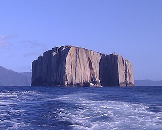
Refuge Island is a flat granite island, with an area of about 6 ha, in south-eastern Australia. It is part of the Schouten Island Group, lying close to the eastern coast of Tasmania near the Freycinet Peninsula and is part of the Freycinet National Park.
Hippolyte Rocks is a small granite island, with an area of 5.3 ha, in south-eastern Australia. It is part of the Tasman Island Group, lying close to the south-eastern coast of Tasmania around the Tasman Peninsula. It has a flat top and is surrounded by steep cliffs up to 65 m in height. It is part of the Tasman National Park.
Little Spectacle Island is a small island, with an area of 0.62 ha, part of the Sloping Island Group, lying close to the south-eastern coast of Tasmania, Australia around the Tasman and Forestier Peninsulas, and adjacent Spectacle Island.
Barren Island is a small island, with an area of 0.53 ha, in south-eastern Australia. It is part of the Sloping Island Group, lying close to the south-eastern coast of Tasmania around the Tasman and Forestier Peninsulas.
Sloping Island, incorporating the adjacent Sloping Reef, is an island nature reserve, with an area of 117 ha, in Tasmania in south-eastern Australia. It is part of the Sloping Island Group, lying close to the south-eastern coast of Tasmania around the Tasman and Forestier Peninsulas.

Smooth Island, is a privately owned island with an area of 59.31 ha lying close to the south-eastern coast of Tasmania, Australia. The island is part of the Sloping Island Group situated in Norfolk Bay and surrounded by the Tasman and Forestier Peninsulas. The towns Dunalley and Murdunna are nearby. Smooth Island differs from other Tasmanian islands as it has an unencumbered freehold title down to the high-water mark.
Fulham Island is a privately owned island with an area of 10 hectares. It is part of the Sloping Island Group, lying close to the south-eastern coast of Tasmania around the Tasman and Forestier Peninsulas in Tasmania, Australia.
Visscher Island is an island, with an area of 3.4 ha, in south-eastern Tasmania, in Australia.
Green Island is a small island nature reserve with an area of 4.17 ha close to the south-eastern coast of Tasmania, Australia at the entrance to the River Derwent.
The Sloping Island Group is a group of small islands in south-eastern Tasmania in Australia. They lie close to the south-eastern coast of Tasmania around the Tasman and Forestier Peninsulas.

Isle of the Dead is a small island adjacent to Port Arthur, Tasmania, Australia. The island is historically significant as it retains an Aboriginal coastal shell midden, one of the first recorded sea-level benchmarks, and one of the few preserved Australian convict-period burial grounds. Isle of the Dead forms part of the Port Arthur Historic Site. This site is part of Australian Convict Sites and is listed as a World Heritage Property, as it represents convictism in the era of British colonisation.
The Tasmanian Seafarers' Memorial is a public memorial structure located at Triabunna, Tasmania which jointly commemorates all Tasmanians whose lives were lost at sea, along with the lives of all seafarers of any origin who lost their lives in Tasmanian waters. The memorial comprises individual commemorative plaques for each maritime tragedy involving recreational, commercial, mercantile or naval vessels and personnel lost since 1803. As-at February 2017, the memorial contained plaques for 116 tragic events involving the loss of over 1450 lives.

