Maatsuyker Island is an island located close to the south coast of Tasmania, Australia. The 186-hectare (0.72 sq mi) island is part of the Maatsuyker Islands Group, and comprises part of the Southwest National Park and the Tasmanian Wilderness World Heritage Site.

The Breaksea Islands Group is a group of six islands, in the Southern Ocean, off the southwestern coast of Tasmania, Australia.
Kathleen Island is a steeply cliffed island that lies within Port Davey, an oceanic inlet, located in the south west region of Tasmania, Australia. The island has an area of approximately 11.35 hectares and is contained with the Southwest National Park, part of the Tasmanian Wilderness World Heritage Site and the Port Davey/Bathurst Harbour Marine Nature Reserve.
The Needle Rocks, also known as the Needles, are a group of five main rock islets located close to the south-western coast of Tasmania, Australia. With a combined area of approximately 10.5 hectares (0.041 sq mi), the islets are part of the Maatsuyker Islands Group, and comprise part of the Southwest National Park and the Tasmanian Wilderness World Heritage Site.
Craggy Island is a rugged granite island, with an area of 38.88 ha, in south-eastern Australia. It is part of Tasmania’s Bass Pyramid Group lying in northern Bass Strait between Flinders Island and the Kent Group.

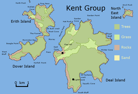
The Judgement Rocks, part of the Kent Group, is a small unpopulated 0.39-hectare (0.96-acre) granite islet and some associated bare rocks, located in the Bass Strait, lying off the north-east coast of Tasmania, between the Furneaux Group and Wilsons Promontory in Victoria, Australia. The islet and associated rocks are contained within the Kent Group National Park.
Deal Island, the largest island of the Kent Group, is a 1,576-hectare (3,890-acre) granite island, located in northern Bass Strait, that lies between the Furneaux Group, north-east of Tasmania, and Wilsons Promontory, in Victoria, Australia.
Erith Island, the second largest island in the Kent Group, is a densely vegetated and unpopulated 323-hectare (800-acre) granite island with steep slopes, located in the Bass Strait, lying off the north-east coast of Tasmania, between the Furneaux Group and Wilsons Promontory in Victoria, Australia.
The North East Isle, part of the Kent Group, is an unpopulated 32.62-hectare (80.6-acre) granite island, located in the Bass Strait, lying off the north-east coast of Tasmania, between the Furneaux Group and Wilsons Promontory in Victoria, Australia.
The South West Isle, part of the Kent Group, is an unpopulated 19.09-hectare (47.2-acre) granite island, located in the Bass Strait, lying off the north-east coast of Tasmania, between the Furneaux Group and Wilsons Promontory in Victoria, Australia.
The Bass Pyramid, part of the Furneaux Group, is a small, two sectioned oval, steep-sided 100-square-metre (1,100 sq ft) unpopulated granite island, located in Bass Strait, lying north of the Flinders Island and south of the Kent Group, in Tasmania, Australia. A rock bridge connects the two sections.
Hen Island is an island located close to the south-western coast of Tasmania, Australia. The 7.6-hectare (0.029 sq mi) island is part of the Maatsuyker Islands Group, and comprises part of the Southwest National Park and the Tasmanian Wilderness World Heritage Site.

The Ile du Golfe is a limestone island located close to the south-western coast of Tasmania, Australia. The long, narrow dolphin-shaped 68-hectare (0.26 sq mi) island is part of the Maatsuyker Islands Group, and comprises part of the Southwest National Park and the Tasmanian Wilderness World Heritage Site.

Louisa Island is an island with a short sandy tombolo, located adjacent to the south-western coast of Tasmania, Australia. The irregularly shaped 23-hectare (0.089 sq mi) island is part of the Maatsuyker Islands Group, and comprises part of the Southwest National Park and the Tasmanian Wilderness World Heritage Site.

Flat Witch Island, also known as Little Witch Island, is an island located close to the south-western coast of Tasmania, Australia. The 64-hectare (0.25 sq mi) island is part of the Maatsuyker Islands Group, and comprises part of the Southwest National Park and the Tasmanian Wilderness World Heritage Site.
Walker Island is an island located close to the south-western coast of Tasmania, Australia. The 15-hectare (0.058 sq mi) island is part of the Maatsuyker Islands Group, and comprise part of the Southwest National Park and the Tasmanian Wilderness World Heritage Site.
Flat Top Island is an island located close to the south-western coast of Tasmania, Australia. The 1.58-hectare (0.0061 sq mi) island is part of the Maatsuyker Islands Group, and comprises part of the Southwest National Park and the Tasmanian Wilderness World Heritage Site.
Round Top Island is an island located close to the south-western coast of Tasmania, Australia. The 6.25-hectare (0.0241 sq mi) island is part of the Maatsuyker Islands Group, and comprises part of the Southwest National Park and the Tasmanian Wilderness World Heritage Site.
Lourah Island is an unpopulated island located close to the south-western coast of Tasmania, Australia. Situated within Port Davey, the 4.86-hectare (12.0-acre) island is part of the Swainson Islands Group, and comprises part of the Southwest National Park and the Tasmanian Wilderness World Heritage Site.
The Fitzroy Islands comprise a group of four rocky islets that lie within the upper reaches of Payne Bay in Port Davey, an oceanic inlet, located in the south west region of Tasmania, Australia. The islands have a combined area of approximately 0.18 hectares and are contained with the Southwest National Park, part of the Tasmanian Wilderness World Heritage Site and the Port Davey/Bathurst Harbour Marine Nature Reserve.