
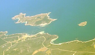
Waterhouse Island, part of the Waterhouse Island Group, is a 287-hectare (710-acre) granite island situated in Banks Strait, part of Bass Strait, lying close to the north-eastern coast of Tasmania, Australia.
The Long Island, part of the Long Island Group within the Furneaux Group, is a 313-hectare (770-acre) unpopulated granite and dolerite island, located in Bass Strait, lying north-west of the Cape Barren Island in Tasmania, in south-eastern Australia. The island is part of the Franklin Sound Islands Important Bird Area, identified as such by BirdLife International because it holds over 1% of the world populations of six bird species.
The Oyster Rocks are a close pair of small granite islands, with a combined area of about 6 ha, in south-eastern Australia. They are part of Tasmania’s Tin Kettle Island Group, lying in eastern Bass Strait between Flinders and Cape Barren Islands in the Furneaux Group. They are a conservation area. The islands are part of the Franklin Sound Islands Important Bird Area, identified as such by BirdLife International because it holds over 1% of the world populations of six bird species.

The Bird Rock, part of the Waterhouse Island Group, is an uninhabited 1-hectare (2.5-acre) granite islet situated in Banks Strait, part of Bass Strait, lying close to the north-eastern coast of Tasmania, Australia.

The Passage Island, part of the Passage Group within the Furneaux Group, is a 253-hectare (630-acre) granite and dolerite island, located in Bass Strait south of Cape Barren Island, in Tasmania, in south-eastern Australia.
Key Island, with the adjacent Key Reef, is a granite island, with an area of 6 ha, in south-eastern Australia. It is part of Tasmania’s Long Island Group, lying in eastern Bass Strait west of Cape Barren Island in the Furneaux Group. The ketch 'Grace Victoria Holyman' was wrecked near here in Thunder & Lightning Bay in 1897.

Tin Kettle Island is a long, sandy island, with an area of 176 ha, in south-eastern Australia. It is part of Tasmania’s Tin Kettle Island Group, lying in eastern Bass Strait between Flinders and Cape Barren Islands in the Furneaux Group. The island is joined at low tide to nearby Anderson and Little Andersons by extensive intertidal mudflats. The island is farmed, mainly cattle grazing. The island is part of the Franklin Sound Islands Important Bird Area, identified as such by BirdLife International because it holds over 1% of the world populations of six bird species.
Little Dog Island is a square, flat granite island, with an area of 83 ha, in south-eastern Australia. It is part of Tasmania’s Great Dog Island Group, lying in eastern Bass Strait between Flinders and Cape Barren Islands in the Furneaux Group. It is a game reserve. It was previously grazed, a usage now ceased. The island is part of the Franklin Sound Islands Important Bird Area, identified as such by BirdLife International because it holds over 1% of the world populations of six bird species.
The East Kangaroo Island, part of the Big Green Group within the Furneaux Group, is a 157-hectare (390-acre) unpopulated limestone island with granite outcrops and dolerite dykes, located in the Bass Strait, west of the Flinders Island, in Tasmania, in south-eastern Australia.
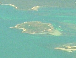
The Big Green Island, part of the Big Green Group within the Furneaux Group, is a 122-hectare (300-acre) granite island with limestone and dolerite outcrops, located in Bass Strait west of Flinders Island, in Tasmania, in south-eastern Australia. The island is partly contained within a nature reserve with the rest being used for farming; and is part of the Chalky, Big Green and Badger Island Groups Important Bird Area.
The Little Chalky Island, part of the Big Green Group within the Furneaux Group, is a 5-hectare (12-acre) unpopulated granite island, located in the Bass Strait, west of the Flinders Island and south of Chalky Island, in Tasmania, in south-eastern Australia. The island is part of the Chalky, Big Green and Badger Island Groups Important Bird Area.

The Chalky Island, part of the Big Green Group within the Furneaux Group, is a 41-hectare (100-acre) unpopulated granite island with limestone outcrops and dolerite dykes, located in the Bass Strait, west of the Flinders Island, in Tasmania, in south-eastern Australia. The island is contained within a conservation area and is part of the Chalky, Big Green and Badger Island Groups Important Bird Area.
The Ninth Island, part of the Waterhouse Island Group, is a 32-hectare (79-acre) uninhabited granite island situated in Bass Strait, lying close to the north-eastern coast of Tasmania, Australia. In November 2018, it was listed for sale for the fourth time, at $1.98 million. The property for sale is a landlocked title within a conservation covenant, preventing access to the island by any means except helicopter.
The Little Waterhouse Island, part of the Waterhouse Island Group, is a 2.5-hectare (6.2-acre) granite island situated in Banks Strait, part of Bass Strait, lying close to the north-eastern coast of Tasmania, Australia.
The Baynes Island, part of the Waterhouse Island Group, are a group of three granite uninhabited islets connected at low tide, with a combined area of 1.62 hectares, situated in Banks Strait, part of Bass Strait, lying close to the north-eastern coast of Tasmania, Australia.

The Cygnet Island, part of the Waterhouse Island Group, is a 0.5-hectare (1.2-acre) granite islet situated in Banks Strait, part of Bass Strait, lying close to the north-eastern coast of Tasmania, Australia.

The Foster Islands, part of the Waterhouse Island Group, are two small granite islands with a combined area of 48 hectares situated in Banks Strait, part of Bass Strait, lying close to the north-eastern coast of Tasmania, Australia. The islands form part of Small Bass Strait Island nature reserve.
The Little Swan Island, part of the Waterhouse Island Group, is a 12.64-hectare (31.2-acre) uninhabited granite island situated in Banks Strait, part of Bass Strait, lying close to the north-eastern coast of Tasmania, Australia.
The George Rocks, also historically known as King George's Rocks, is part of the Waterhouse Island Group, a group of three adjacent uninhabited granite islets and associated reefs with a combined area of 7 hectares, situated in Banks Strait, part of Bass Strait, lying close to the north-eastern coast of Tasmania, Australia.
The Paddys Island, part of the Waterhouse Island Group, is a 4.6-hectare (11-acre) uninhabited granite island situated in the Tasman Sea, lying close to the north-eastern coast of Tasmania, Australia.

