Related Research Articles

Macquarie Island is an island in the southwestern Pacific Ocean, about halfway between New Zealand and Antarctica. Regionally part of Oceania and politically a part of Tasmania, Australia, since 1900, it became a Tasmanian State Reserve in 1978 and was inscribed as a UNESCO World Heritage Site in 1997.
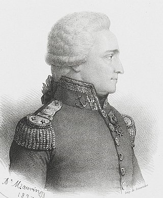
Antoine Raymond Joseph de Bruni, chevalier d'Entrecasteaux was a French naval officer, explorer and colonial governor. He is perhaps best known for his exploration of the Australian coast in 1792, while searching for the La Pérouse expedition. Antoine Bruni d'Entrecasteaux is commonly referred to simply as Bruni d'Entrecasteaux or Bruny d'Entrecasteaux, each of which is a compound surname.

The Parliament of Tasmania is the bicameral legislature of the Australian state of Tasmania. It follows a Westminster-derived parliamentary system and consists of the Governor of Tasmania, the Tasmanian House of Assembly, and Tasmanian Legislative Council. Since 1841, both Houses have met in Parliament House, Hobart. The Parliament of Tasmania first met in 1856.

Sullivans Cove is on the River Derwent adjacent to the Hobart City Centre in Tasmania. It was the site of initial European settlement in the area, and the location of the earlier components of the Port of Hobart.
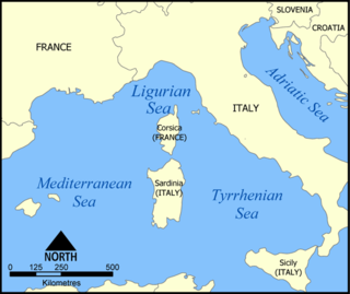
The Ligurian Sea is an arm of the Mediterranean Sea. It lies between the Italian Riviera (Liguria) and the island of Corsica. The sea is thought to have been named after the ancient Ligures people.
Kent Group National Park is located in Bass Strait covering the Kent Group islands of Tasmania, Australia. The islands cover an area of 23.74 km2 (9.17 sq mi) while the marine reserve component of the national park which surrounds the islands cover 290 km2 (110 sq mi).
The Anglican Diocese of Tasmania includes the entire Tasmanian archipelago and is an extraprovincial diocese of the Anglican Church of Australia.

The Doone Kennedy Hobart Aquatic Centre is a major, $17 million aquatic sporting facility located upon the Queens Domain, within less than 1 kilometre of the CBD of Hobart, the capital city of Tasmania, Australia. The venue has hosted the Australian Swimming Championships, the Tasmanian Swimming Championships, FINA Swimming World Cup, Pan Pacific Games and the Qantas Skins. Other major events held at the venue throughout its first seven years of operation include the Australian Canoe Polo Championships, Australian Diving Championships, Australian Water Polo Under Age and National League events and the World and Australian Underwater Hockey Championships.

The Tasmanian Museum and Art Gallery (TMAG) is a museum located in Hobart, Tasmania. The museum was established in 1846, by the Royal Society of Tasmania, the oldest Royal Society outside England. The TMAG receives 400,000 visitors annually.
Buckingham Land District is one of the twenty land districts of Tasmania which are part of the Lands administrative divisions of Tasmania. It was formerly Buckingham County, one of the 18 counties of Tasmania and one of the first eleven proclaimed in 1836 and is bordered to the north by the River Derwent, and to the south by the Huon River. It includes Bruny Island. Hobart is located in the county. It was named after the then county of England.

Smooth Island, is a privately owned island with an area of 59.31 ha lying close to the south-eastern coast of Tasmania, Australia. The island is part of the Sloping Island Group situated in Norfolk Bay and surrounded by the Tasman and Forestier Peninsulas. The towns Dunalley and Murdunna are nearby. Smooth Island differs from other Tasmanian islands as it has an unencumbered freehold title down to the high-water mark.
Fulham Island is a privately owned island with an area of 10 hectares. It is part of the Sloping Island Group, lying close to the south-eastern coast of Tasmania around the Tasman and Forestier Peninsulas in Tasmania, Australia.
The Hope Island, part of the Partridge Island Group, is a small island that lies close to the south-eastern coast of Tasmania, Australia. The island is located in the D'Entrecasteaux Channel between Bruny Island and the Tasmanian mainland. Its neighbouring islets are named Faith and Charity, and also the Arch Rock.

Woolmers Estate is a farming estate located in Longford, Tasmania, founded in 1817 by prominent grazier and member of parliament Thomas Archer. It consists of an 82ha property, including a two-part manor house, coach house, the National Rose Garden, extensive outbuildings and convict cottages and formal gardens. The main house consists of a brick nog weatherboard homestead, built in 1819, with an attached extensive addition in Italiate style, designed by William Archer and built in 1842-1843. From the 1819 completion of the main house to 1994, it was one of the main ancestral homes of the Archer family.
The Basslink electricity interconnector is a 370 km (230 mi) 500 MW (670,000 hp) high-voltage direct current (HVDC) cable linking the electricity grids of the states of Victoria and Tasmania in Australia, crossing Bass Strait, connecting the Loy Yang Power Station, Victoria on the Australian mainland to the George Town substation in northern Tasmania. Basslink is bidirectional and enables Hydro Tasmania to supply some of the peak load capacity to the Australian mainland and take some of the excess power from the mainland when the generation on the mainland exceeds the demand.
The Norfolk Bay is a body of water in the south east of Tasmania, Australia. The north west aspect of Norfolk Bay is continuous with Frederick Henry Bay. The north east aspect of Norfolk Bay is continuous with Blackman Bay via the Denison Canal.
Boxalls Bay is a small bay located on the western side of the Forestier Peninsula, facing Norfolk Bay. It lies south of Tinpot Island and North of Eaglehawk Neck.

The Cam River estuary is located in Somerset roughly halfway between the township of Wynyard and the city of Burnie on the North West Coast of Tasmania. The northern part of the Cam River forms part of the boundary between the City of Burnie and Waratah-Wynyard local government areas.
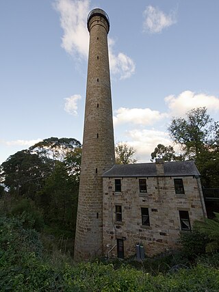
The Shot Tower at Taroona is a heritage listed historic building between Hobart and Kingston, Tasmania. It was the tallest building in Australia for four years (1870-1875), and the tallest structure in Tasmania until it was superseded by the Mount Wellington broadcast tower in 1960. The Taroona Shot Tower is believed to be the tallest circular sandstone tower in the world.
References
- ↑ "Redirect". maps.thelist.tas.gov.au. Archived from the original on 23 December 2014. Retrieved 17 January 2022.
- ↑ "COASTAL MANAGEMENT" (PDF). Jaconline.com.au. Retrieved 28 December 2014.
- ↑ "Tinpot Island". Au.geoview.info. Retrieved 28 December 2014.
- ↑ "ITINERARY - 2013 (SUBJECT TO CHANGE)" (PDF). Apollo.hutchins.tas.edu.au. Archived from the original (PDF) on 28 December 2014. Retrieved 28 December 2014.
Coordinates: 43°00′S147°50′E / 43.000°S 147.833°E
| | This Tasmania geography article is a stub. You can help Wikipedia by expanding it. |