Related Research Articles
The Middle Pasco Islands comprise two similarly sized adjacent granite islands, with a combined area of 8.37 ha, in south-eastern Australia. They form part of Tasmania’s Pasco Island Group, lying in eastern Bass Strait off the north-west coast of Flinders Island in the Furneaux Group.
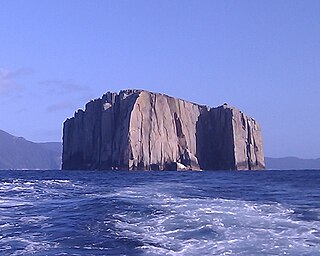
Hippolyte Rocks is a small granite island, with an area of 5.3 ha, in south-eastern Australia. It is part of the Tasman Island Group, lying close to the south-eastern coast of Tasmania around the Tasman Peninsula. It has a flat top and is surrounded by steep cliffs up to 65 m in height. It is part of the Tasman National Park.

The Thumbs is a small and jagged island, with three prominent spires and an area of 4,500 square metres, in south-eastern Australia. It is part of the Tasman Island Group, lying close to the south-eastern coast of Tasmania around the Tasman Peninsula, and is in the Tasman National Park.
The Wedge Island, part of the Tasman Island Group, is an island with an area of 43 hectares lying close to the south-eastern coast of Tasmania, Australia. The island is located in Storm Bay, situated off the Tasman Peninsula.
Spectacle Island is a 3.5-hectare (8.6-acre) island in south-eastern Australia. It is part of the Sloping Island Group, lying close to the south-eastern coast of Tasmania around the Tasman and Forestier Peninsulas. Recorded breeding seabird and wader species are little penguin, short-tailed shearwater and pied oystercatcher.
Little Spectacle Island is a small island, with an area of 0.62 ha, part of the Sloping Island Group, lying close to the south-eastern coast of Tasmania, Australia around the Tasman and Forestier Peninsulas, and adjacent Spectacle Island.
Barren Island is a small island, with an area of 0.53 ha, in south-eastern Australia. It is part of the Sloping Island Group, lying close to the south-eastern coast of Tasmania around the Tasman and Forestier Peninsulas.

Sloping Island, incorporating the adjacent Sloping Reef, is an island nature reserve, with an area of 117 ha, in Tasmania in south-eastern Australia. It is part of the Sloping Island Group, lying close to the south-eastern coast of Tasmania around the Tasman and Forestier Peninsulas.
Fulham Island is a privately owned island with an area of 10 hectares. It is part of the Sloping Island Group, lying close to the south-eastern coast of Tasmania around the Tasman and Forestier Peninsulas in Tasmania, Australia.
Visscher Island is an island, with an area of 3.4 ha, in south-eastern Tasmania, in Australia.

Iron Pot is a small flat sandstone island with an area of 1.27 ha in south-eastern Australia. It is part of the Betsey Island Group, lying close to the south-eastern coast of Tasmania around the entrance to the River Derwent. It is the site of the Iron Pot Lighthouse, Tasmania's first lighthouse.
Arch Rock is a sandstone islet, with an area of 0.44 ha and containing a natural arch, in south-eastern Australia. It is part of the Partridge Island Group, lying close to the south-eastern coast of Tasmania, in the D'Entrecasteaux Channel between Bruny Island and the mainland.
Charity Island is an islet with an area of 0.6 ha in south-eastern Australia. It is part of the Partridge Island Group, lying close to the south-eastern coast of Tasmania, in the D'Entrecasteaux Channel between Bruny Island and the mainland. Its neighbouring islets are named "Faith" and "Hope".
Southport Island, with the adjacent Southport Reef, is a 7 ha island in south-eastern Australia. It is part of the Actaeon Island Group, lying close to the south-eastern coast of Tasmania, at the southern entrance to the D'Entrecasteaux Channel between Bruny Island and the mainland.
Blanche Rock is a 0.07 ha dolerite islet in south-eastern Australia. It is part of the Actaeon Island Group, lying close to the south-eastern coast of Tasmania, at the southern entrance to the D'Entrecasteaux Channel between Bruny Island and the mainland. It is part of the South Bruny National Park.
The Mackerel Islets are two small islands in south-eastern Australia. They are part of the Tasman Island Group, lying close to the south-eastern coast of Tasmania around the Tasman Peninsula.

King George Island is an island in south-eastern Australia. It is part of the Sloping Island Group, lying close to the south-eastern coast of Tasmania around the Tasman and Forestier Peninsulas. The island was once inhabited and farmed and contains the ruins of two buildings on its eastern side. A conservation covenant is in place on this island.
Garden Island is a small stony island that is part of the Partridge Island Group, lying close to the south-eastern coast of Tasmania, Australia, in the D'Entrecasteaux Channel between Bruny Island and the mainland. The D'Entrecasteaux Channel is the mouth for the Huon River.
The Faith Island, part of Partridge Island Group, is a low, flat islet in south-eastern Tasmania, Australia. The islet lies in the D'Entrecasteaux Channel between Bruny Island and the Tasmania mainland. It contains two gravestones, concealed in the scrub in the north-east of the island. Its neighbouring islets are named Charity and Hope and also the Arch Rock.
The Sloping Island Group is a group of small islands in south-eastern Tasmania in Australia. They lie close to the south-eastern coast of Tasmania around the Tasman and Forestier Peninsulas.
References
Notes
- ↑ Brothers et al (2001), p.606.
Sources
- Brothers, Nigel; Pemberton, David; Pryor, Helen; & Halley, Vanessa. (2001). Tasmania’s Offshore Islands: seabirds and other natural features. Tasmanian Museum and Art Gallery: Hobart. ISBN 0-7246-4816-X
| | This Tasmania geography article is a stub. You can help Wikipedia by expanding it. |