
Tasmania is an island state of Australia. It is located 240 kilometres to the south of the Australian mainland, and is separated from it by the Bass Strait. The state encompasses the main island of Tasmania, the 26th-largest island in the world, and the surrounding 1000 islands. It is Australia's least populous state, with 573,479 residents as of June 2023. The state capital and largest city is Hobart, with around 40% of the population living in the Greater Hobart area. Tasmania is the most decentralised state in Australia, with the lowest proportion of its residents living within its capital city.
Margate is a small seaside town on the Channel Highway between North-West Bay and the Snug Tiers, 7 kilometres (4 mi) south of Kingston in Tasmania, Australia. It is mostly in the Kingborough Council area, with about 4% in the Huon Valley Council LGA. Margate is also part of the Greater Hobart statistical area.

Flinders Island, the largest island in the Furneaux Group, is a 1,367-square-kilometre (528 sq mi) island in the Bass Strait, northeast of the island of Tasmania. Today Flinders Island is part of the state of Tasmania, Australia. It is 54 kilometres (34 mi) from Cape Portland and is located on 40° south, a zone known as the Roaring Forties.

Sorell is a town in Tasmania, Australia, north-east of Hobart. It is located on the Tasman Highway at the junction with the Arthur Highway. Sorell is one of Tasmania's oldest towns, being first settled in 1808 as a small farming community and becoming an official township in 1821. At the 2006 census, Sorell had a population of 1,546, and at the 2011 census, a population of 2,476. and at the 2016 census, a population of 2,907.

Glamorgan-Spring Bay Council is a local government body in Tasmania, situated on the central east coast of the state. Glamorgan-Spring Bay is classified as a rural local government area and has a population of 4,528, the major towns of the region include Bicheno, Orford and Swansea with Triabunna the principal town.
Rosebery is a town on the west coast of Tasmania, Australia. It is at the northern end of the West Coast Range, in the shadow of Mount Black and adjacent to the Pieman River, now Lake Pieman.
Smithton is a town on the far north-west coast of Tasmania, Australia. It lies on the Bass Highway, 85 km north-west of Burnie. At the 2021 census, Smithton had a population of 3,934. Smithton is the administrative centre of the Circular Head Council.
Strathgordon is a rural locality in the local government area (LGA) of Derwent Valley in the South-east LGA region of Tasmania. The locality is about 121 kilometres (75 mi) west of the town of New Norfolk. The 2016 census recorded a population of 15 for the state suburb of Southwest, which includes Strathgordon. It is on the road to the Gordon River Dam the most south westerly road in the south west of Tasmania. It is a tourist destination for visitors wishing to visit the Southwest National Park and World Heritage listed wilderness.

Oatlands is an important historical village on the shores of Lake Dulverton in the centre of Tasmania, Australia. Oatlands is located 84 km north of Hobart and 115 km south of Launceston on the Midland Highway. At the 2021 census, Oatlands had a population of 728.

Woodbridge is a semi-rural locality in the local government area (LGA) of Kingborough in the Hobart LGA region of Tasmania. The locality is about 26 kilometres (16 mi) south of the town of Kingston. The 2021 Census recorded a population of 547 for the state suburb of Woodbridge, with the median age being 54. There are 180 families living in Woodbridge, with a mean of 1.8 children per household. It is located 38 kilometres (24 mi) south of the state capital, Hobart.
Dover is the southernmost town of its size in Australia, located on the western shores towards the southern end of the D'Entrecasteaux Channel, just south of the Huon Valley, southwest of Hobart, located on the head of Port Esperance in Tasmania. It has a population of 486; 91% were born in Australia and 5% was born in United Kingdom, with other less common origins such as New Zealand, Germany and Greece all clustering around the 1% mark.

The Freycinet Peninsula is a large peninsula located on the eastern coast of Tasmania, Australia. The peninsula is located north of Schouten Island and is contained within the Freycinet National Park.

Schouten Island, part of the Schouten Island Group, is an island with an area of approximately 28 square kilometres (11 sq mi) lying close to the eastern coast of Tasmania, Australia, located 1.6 kilometres (0.99 mi) south of the Freycinet Peninsula and is a part of Freycinet National Park. The palawa kani place name for the island is mayaluwarana.
Eaglehawk Neck, officially Teralina / Eaglehawk Neck, is a narrow isthmus that connects the Tasman Peninsula with the Forestier Peninsula and hence to the rest of Tasmania, Australia.

Campbell Town is a town in Tasmania, Australia, on the Midland Highway. At the 2021 census, the town had a population of 823.

Triabunna is a rural residential locality in the local government area (LGA) of Glamorgan–Spring Bay in the South-east LGA region of Tasmania. The locality is about 86 kilometres (53 mi) north-east of the city of Hobart. The 2021 census has a population of 905 for the state suburb of Triabunna.

Glamorgan Land District is one of the twenty land districts of Tasmania which are part of the Cadastral divisions of Tasmania. It was formerly one of the 18 counties of Tasmania. It is located along the eastern edge of Tasmania, from Seymour in the north, to Pontypool in the south. It includes Swansea, Bicheno, Cranbrook, and Lisdillon. It also includes the area around Great Oyster Bay, the Freycinet Peninsula and Schouten Island. The LGA of Glamorgan Spring Bay Council is in a similar region.

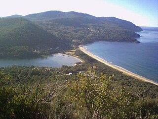
Coles Bay is an Australian town on the east Coast of Tasmania 192 km north-east of Hobart and 173 km south-east of Launceston, being the main entrance point for visitors to the Freycinet National Park.
Great Oyster Bay is a broad and sheltered bay on the east coast of Tasmania, Australia which opens onto the Tasman Sea. The Tasman Highway runs close to the West Coast of the bay with views of the granite peaks of the Hazards and Schouten Island of the Freycinet Peninsula which are incorporated in the Freycinet National Park.
Oyster Cove is a semi-rural locality in the local government areas (LGA) of Kingborough and Huon Valley in the Hobart and South-east LGA regions of Tasmania. The locality is about 20 kilometres (12 mi) south-west of the town of Kingston. The 2016 census has a population of 319 for the state suburb of Oyster Cove. Part of Oyster Cove is an Indigenous Protected Area due to its history as a colonial holding facility for Aboriginal Tasmanians.


