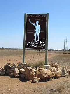
Blackwater is both a town and a locality in the Central Highlands Region, Queensland, Australia, 190 km west of Rockhampton. It is a town in a significant coal mining area in Central Queensland. The name of the township was inspired by the dark colour of local waterholes.
Little River (Dubbo), a watercourse of the Macquarie catchment within the Murray-Darling basin, is located in the central western and Orana districts of New South Wales, Australia.

Catherine Hill Bay is a coastal bay and village on the southern peninsula forming Lake Macquarie, south of the Pacific Ocean entrance channel at Swansea in New South Wales, Australia. It is part of the City of Lake Macquarie local government area. The village is the oldest continuous settlement in the City of Lake Macquarie.
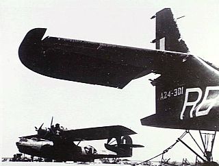
No. 42 Squadron was a Royal Australian Air Force (RAAF) mine laying and maritime patrol squadron of World War II. It was formed in June 1944 and conducted patrol and mine-laying operations over the Netherlands East Indies (NEI) from August 1944 until the war ended a year later, as well as operations in the waters off southern China in early 1945. Following the Japanese surrender, the squadron performed transport and reconnaissance flights until it was disbanded in November 1945.

The George Grant University of Mines and Technology (GGUMaT) is a public university located at Tarkwa in the Western Region of Ghana.
The Bombala River, a perennial river of the Snowy River catchment, is located in the Monaro region of New South Wales, Australia.
Key Island, with the adjacent Key Reef, is a granite island, with an area of 6 ha, in south-eastern Australia. It is part of Tasmania’s Long Island Group, lying in eastern Bass Strait west of Cape Barren Island in the Furneaux Group.
The ketch 'Grace Victoria Holyman' was wrecked near here in Thunder & Lightning Bay in 1897.

The Shire of Orbost was a local government area about 380 kilometres (236 mi) east of Melbourne, the state capital of Victoria, Australia. The shire covered an area of 9,347 square kilometres (3,608.9 sq mi), and existed from 1892 until 1994.
Friendly Beaches Reserve is a 140 ha coastal nature reserve in eastern Tasmania, Australia, 190 km north-east of Hobart and 180 km south-east of Launceston. It is located on the north-east side of the Freycinet Peninsula, bordering the Freycinet National Park. It is owned and managed by Bush Heritage Australia (BHA), by which it was purchased in 1997.

Hayman Island is the most northerly of the Whitsunday Islands, part of the Cumberland Islands, which are located off the coast of Central Queensland, Australia at 20°03′S 148°53′E. Hayman is a private island open to the public, most famous for its luxury resort which was built in the 1950s by millionaire Reg Ansett, who also founded Ansett Australia. The island is a significant drawing point for tourism in Queensland.

The Nuggets is a close group of four granite islets, with a combined area of 6.76 hectares, in south-eastern Australia. It is part of the Schouten Island Group, lying close to the eastern coast of Tasmania near the Freycinet Peninsula.
Ile des Phoques is a rugged granite island, with an area of 8 ha, part of the Schouten Island Group, lying close to the eastern coast of Tasmania, Australia near the Freycinet Peninsula.
Refuge Island is a flat granite island, with an area of about 6 ha, in south-eastern Australia. It is part of the Schouten Island Group, lying close to the eastern coast of Tasmania near the Freycinet Peninsula and is part of the Freycinet National Park.

Great Oyster Bay is a broad and sheltered bay on the east coast of Tasmania, Australia which opens onto the Tasman Sea. The Tasman Highway runs close to the West Coast of the bay with views of the granite peaks of the Hazards and Schouten Island of the Freycinet Peninsula which are incorporated in the Freycinet National Park.

The Bay of Fires is a bay on the northeastern coast of Tasmania in Australia, extending from Binalong Bay to Eddystone Point. The bay was given its name in 1773 by Captain Tobias Furneaux in Adventure,
who saw the fires of Aboriginal people on the beaches.
The Goorudee Rivulet, a perennial river of the Murrumbidgee catchment of the Murray-Darling basin, is located in the Snowy Mountains region of New South Wales, Australia.

Posadowsky Glacier is a glacier about 9 nautical miles long, flowing north to Posadowsky Bay immediately east of Gaussberg. Posadowsky Bay is an open embayment, located just east of the West Ice Shelf and fronting on the Davis Sea in Kaiser Wilhelm II Land. Kaiser Wilhelm II Land is the part of East Antarctica lying between Cape Penck, at 87°43'E, and Cape Filchner, at 91°54'E, and is claimed by Australia as part of the Australian Antarctic Territory. Other notable geographic features in this area include Drygalski Island, located 45 mi NNE of Cape Filchner in the Davis Sea, and Mirny Station, a Russian scientific research station.

Moulting Lagoon Important Bird Area is a composite wetland site in eastern Tasmania, Australia. It comprises two adjacent and hydrologically continuous wetlands – Moulting Lagoon and the Apsley Marshes – at the head of Great Oyster Bay, near the base of the Freycinet Peninsula, between the towns of Swansea and Bicheno. Both components of the site are listed separately under the Ramsar Convention as wetlands of international significance. Moulting Lagoon is so named because it is a traditional moulting place for black swans. It is an important site for waterbirds.
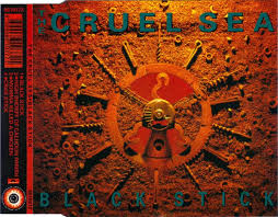
"Black Stick" is a 1993 song from Australian rock band The Cruel Sea. The song was released in March 1993 as the lead single from the band's third studio album, The Honeymoon Is Over. The song peaked at number 25 on the ARIA Charts.