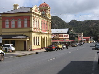
Queenstown is a town in the West Coast region of the island of Tasmania, Australia. It is in a valley on the western slopes of Mount Owen on the West Coast Range.

Zeehan is a town on the west coast of Tasmania, Australia 139 kilometres (86 mi) south-west of Burnie. It is part of the West Coast Council, along with the seaport Strahan and neighbouring mining towns of Rosebery and Queenstown.

The West Coast Range is a mountain range located in the West Coast region of Tasmania, Australia.
Mount Lyell is a mountain in the West Coast Range of Western Tasmania, Australia.
Mount Lyell Mining and Railway Company was a Tasmanian mining company formed on 29 March 1893, most commonly referred to as Mount Lyell. Mount Lyell was the dominant copper mining company of the West Coast from 1893 to 1994, and was based in Queenstown, Tasmania.
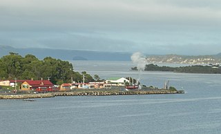
Regatta Point is the location of a port and rail terminus on Macquarie Harbour.
The North Mount Lyell disaster refers to a fire that broke out on 12 October 1912 at the Mount Lyell Mining and Railway Company operations on the West Coast of Tasmania, killing 42 miners. The mine had been taken over from the North Mount Lyell Company in 1903.
Mount Read is a mountain located in the West Coast region of Tasmania, Australia, and is at the north west edge of the West Coast Range.

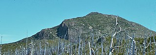
Mount Owen is a mountain directly east of the town of Queenstown on the West Coast Range in Western Tasmania, Australia.

The Queen River, part of the King River catchment, is a minor perennial river located in the West Coast region of Tasmania, Australia. It is notable for its high level of pollution caused by mining runoff which has led the river to be uninhabitable to life.
The Mount Jukes mine sites were a series of short-lived, small mine workings high on the upper regions of Mount Jukes in the West Coast Range on the West Coast of Tasmania.

Mount Huxley is a mountain located on the West Coast Range in the West Coast region of Tasmania, Australia. With an elevation of 926 metres (3,038 ft) above sea level, the mountain was named by Charles Gould in 1863 in honour of Professor Thomas Henry Huxley.
Mount Sedgwick is a mountain located within the West Coast Range, in the West Coast region of Tasmania, Australia.
The history of the railways on the West Coast of Tasmania has fascinated enthusiasts from around the world, because of the combination of the harsh terrain in which the railways were created, and the unique nature of most of the lines.

Linda is the site of an old ghost town in the Linda Valley in the West Coast Range of Tasmania, Australia. It has also been known as Linda Valley.

Mount Murchison is a mountain on the West Coast Range, located in the West Coast region of Tasmania, Australia.

Dundas was a historical mining locality, mineral field and railway location on the western foothills of the West Coast Range in Western Tasmania. It is now part of the locality of Zeehan.
The Zeehan and Dundas Herald was a newspaper for the West Coast Tasmania community, based in Zeehan and Dundas from 1890 to 1922.

Philosophers Ridge is the long spur that connects Mount Lyell and Mount Owen in the West Coast Range of Western Tasmania.

