
The North Mount Lyell Railway was built to operate between the North Mount Lyell mine in West Coast Tasmania and Pillinger in the Kelly Basin of Macquarie Harbour. [1]
The North Mount Lyell Railway was built to operate between the North Mount Lyell mine in West Coast Tasmania and Pillinger in the Kelly Basin of Macquarie Harbour. [1]
At the start of the Twentieth century it was constructed to take ore from Gormanston east of the West Coast Range to the Crotty smelters. From there it was shipped out at Kelly Basin. [2]
The North Mount Lyell Railway had exceptionally easy grades compared to its competitor the Mount Lyell Mining and Railway Company which ran its Abt rack system railway through very steep grades from Queenstown to Regatta Point.
The railway route ran across a belt of karst terrain in the area near the current Darwin Dam – and the engineers of the 1890s were possibly the first in Australia to have designed for the possibility of sinkholes when planning the route. [3]
The line was opened for passengers 15 December 1900, [4] and was taken over by the Mount Lyell Mining and Railway Company on 16 July 1903.
In December 1900, when J.F. Anderson was Chief Superintendent, timetabling had:
Stopping points were Gormanston junction, King River and Ten Mile. [5]
In August 1901, when J.J. Ware was the traffic manager, timetabling for passengers was restricted to one train a day from each end of the line.
The two trains met at Smelters Junction, with the Linda train leaving at 1.30 p.m. and the Kelly Basin train leaving at 2.45 p.m.
The later years of operation of the line a small rail motor was utilised, similar to that on the Lake Margaret Tram in the last years of operation. [6] Due to failure of the Crotty smelters and the North Mount Lyell operations in general, and the amalgamation of the Mount Lyell and North Mount Lyell mines and companies, the railway had a short operational life. [7] It closed to passengers in July 1924 and closed in 1929. [8] [9]

The railway utilised three Avonside Engines:
It also had three Shay engines:
The company also had its own ship (the SS North Lyell) in its service which transported rolling stock to Kelly Basin [11] [12] [13] [14]
The railway bridge at the King River and the old rail formation were utilised right up to the damming of the River and the creation of Lake Burbury by the Hydro Electric Commission in the 1980s. The railway formation between the Linda Valley and the old locality of Darwin is now under water.
The railway formation between Mount Owen and Mount Jukes was known as the Kelly Basin Road during the No Dams campaign of December 1982 – and was a location of interaction between members of the Tasmanian Police and protesters.
Considerable parts of the old railway line alignment are now under Lake Burbury or destroyed by the related works.
Kelly Basin Road is accessed from Jukes Highway, at one point on the left (gated and locked) a track to one of the sites related to the Franklin Dam is located. Kelly Basin Road (the old formation) reaches a bridge, where access is by foot is needed to complete the journey to Kelly Basin. Walking time is 3 to 4 hours one way, but an easy grade.
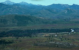
The King River is a major perennial river in the West Coast region of Tasmania, Australia.

The West Coast Range is a mountain range located in the West Coast region of Tasmania, Australia.
Gormanston is a town in Tasmania on the slopes of Mount Owen, above the town of Queenstown in Tasmania's West Coast. In the 2016 census, Gormanston had a population of 17.
Crotty is a former gazetted townsite that was located in Western Tasmania, Australia. The township was located on the eastern lower slopes of Mount Jukes, below the West Coast Range, and on the southern bank of the King River. The locality had had a former name of King River

Mount Owen is a mountain directly east of the town of Queenstown on the West Coast Range in Western Tasmania, Australia.

The Queen River, part of the King River catchment, is a minor perennial river located in the West Coast region of Tasmania, Australia. It is notable for its high level of pollution caused by mining runoff which has led the river to be uninhabitable to life.
Lake Burbury is a man-made water reservoir created by the Crotty Dam inundating the upper King River valley that lies east of the West Coast Range. Discharge from the reservoir feeds the John Butters Hydroelectric Power Station, owned and operated by Hydro Tasmania.

Mount Huxley is a mountain located on the West Coast Range in the West Coast region of Tasmania, Australia. With an elevation of 926 metres (3,038 ft) above sea level, the mountain was named by Charles Gould in 1863 in honour of Professor Thomas Henry Huxley.
North Mount Lyell was the name of a mine, mining company, locality and former railway north of Gormanston on the southern slopes of Mount Lyell in the West Coast Range on the West Coast of Tasmania, and on to the ridge between Mount Lyell and Mount Owen.
Pillinger is an abandoned port and townsite in Kelly Basin, on the south eastern side of Macquarie Harbour on the West Coast of Tasmania.

Linda Valley is a valley in the West Coast Range of Tasmania. It was earlier known as the Vale of Chamouni. It is located between Mount Owen and Mount Lyell.
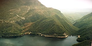
The Crotty Dam, also known during construction as the King Dam, or the King River Dam on initial approval, is a rockfill embankment dam with a controlled and uncontrolled spillway across the King River, between Mount Jukes and Mount Huxley, located in Western Tasmania, Australia.

Kelly Basin is a bay on the south eastern side of Macquarie Harbour on the West Coast of Tasmania.
Darwin was a surveyed and short-lived community at the eastern side of Mount Darwin on the West Coast Range.
The mines of the West Coast of Tasmania have a rich historical heritage as well as an important mineralogical value in containing or having had found, specimens of rare and unusual minerals. Also, the various mining fields have important roles in the understanding of the mineralization of the Mount Read Volcanics, and the occurrence of economic minerals.
The history of the Railways on the West Coast of Tasmania has fascinated enthusiasts from around the world, because of the combination of the harsh terrain in which the railways were created, and the unique nature of most of the lines.

The Darwin Dam is an offstream earthfill embankment saddle dam without a spillway, located in Western Tasmania, Australia. The impounded reservoir, also formed by Crotty Dam, is called Lake Burbury.

Linda is the site of an old ghost town in the Linda Valley in the West Coast Range of Tasmania, Australia. It has also been known as Linda Valley.

Kelly Basin Road was a road built on the formation of the former North Lyell Railway in the King River Valley of Western Tasmania. It ran to the east of the West Coast Range, from the Linda Valley, to Kelly Basin.
James Crotty (1845–1898) was an Irish-born Australian mining prospector who formed a mining company, the North Mount Lyell mining company, in the western region of Tasmania, just before the turn of the twentieth century.