Lake Beatrice

Last updated

Lake Beatrice
Relief Map of Tasmania.png
Red pog.svg
Lake Beatrice
Location in Tasmania
Location West Coast, Tasmania
Coordinates 42°00′S145°32′E / 42.000°S 145.533°E / -42.000; 145.533 Coordinates: 42°00′S145°32′E / 42.000°S 145.533°E / -42.000; 145.533
Type Natural lake
Basin  countriesAustralia
Surface area55 ha (140 acres)
References [1] [2]
southern part of Lake Beatrice from the air in 2001, from the east, Lake Burbury water in top left hand corner Lake Beatrice from the air 2000 from the east.jpg
southern part of Lake Beatrice from the air in 2001, from the east, Lake Burbury water in top left hand corner

Lake Beatrice is a 55-hectare (140-acre) natural lake on the lower eastern side of Mount Sedgwick in the West Coast Range of Western Tasmania, Australia.

Contents

Lake Beatrice is higher in altitude than the nearby Lake Burbury, however it is not visible from that level, but can be seen either from the air or the higher slopes of the eastern part of Mount Lyell.

The lake was a reference point for the planned Great Western Railway that was considered at the end of the nineteenth century; however was never built. [3]

The name of the lake and adjacent ground is tied into exploration leases held in the area. [4]

The 3,000-hectare (7,400-acre) Lake Beatrice Conservation Area starts in the location of Lake Beatrice and continues north to Lake Huntley and Lake Rolleston; [5] and it is bordered on either side by the 14,000-hectare (35,000-acre) Tyndall Regional Reserve. [6] [7]

See also

Related Research Articles

King River (Tasmania) River in Western Tasmania

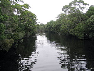
The King River is a major perennial river in the West Coast region of Tasmania, Australia.

West Coast Range Mountain range in Tasmania, Australia

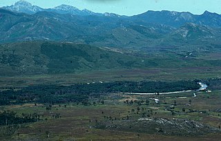
The West Coast Range is a mountain range located in the West Coast region of Tasmania, Australia.

Lake Margaret (Tasmania) Dam in West Coast, Tasmania

Lake Margaret is a concrete-faced gravity dam with an uncontrolled spillway across the Yolande River, located on the north side of Mount Sedgwick, in the West Coast Range, West Coast of Tasmania, Australia.

Mount Read (Tasmania)

Mount Read is a mountain located in the West Coast region of Tasmania, Australia, and is at the north west edge of the West Coast Range.

Queen River, Tasmania

The Queen River, part of the King River catchment, is a minor perennial river located in the West Coast region of Tasmania, Australia.

Lake Burbury

Lake Burbury is a man-made water reservoir created by the Crotty Dam inundating the upper King River valley that lies east of the West Coast Range. Discharge from the reservoir feeds the John Butters Hydroelectric Power Station, owned and operated by Hydro Tasmania.

Mount Sedgwick (Tasmania)

Mount Sedgwick is a mountain located within the West Coast Range, in the West Coast region of Tasmania, Australia.

Darwin Dam Dam in Western Tasmania

The Darwin Dam is an offstream earthfill embankment saddle dam without a spillway, located in Western Tasmania, Australia. The impounded reservoir, also formed by Crotty Dam, is called Lake Burbury.

Henty River

The Henty River is a perennial river in the West Coast region of Tasmania, Australia. The river generally lies north of Queenstown and south of Zeehan.

Mount Murchison (Tasmania)

Mount Murchison is a mountain on the West Coast Range, located in the West Coast region of Tasmania, Australia.

Mount Geikie

Mount Geikie is a mountain in the West Coast Range of Western Tasmania, Australia.

Murchison River (Tasmania)

The Murchison River, part of the Pieman River catchment, is a major perennial river located in the West Coast region of Tasmania, Australia.

Lake Rosebery (Tasmania)

Lake Rosebery is a man-made water reservoir located in the West Coast region of Tasmania, Australia. The lake is situated within the northern part of Tasmania's West Coast Range and is fed by the dammed Mackintosh and Murchison rivers.

Lake Dora (Tasmania) Lake in Tasmania, Australia

Lake Dora is a 48-hectare (120-acre) lake and also short-lived mining area of the late 1890s located in the West Coast Range of Western Tasmania, Australia. It has a surface level of 756 metres (2,480 ft) AHD .

Lake Mackintosh

Lake Mackintosh is a 17.5-kilometre-long (10.9 mi) reservoir with a surface area of 3,100-hectare (7,700-acre) that forms part of the Pieman power development running north–south past Mount Farrell, adjacent to the town of Tullah in Tasmania.

Lake Westwood (Tasmania) Lake in Tasmania, Australia

Lake Westwood is a 35-hectare (86-acre) glacial lake in the Tyndalls peaks to the east of Mount Read, in the West Coast Range, West Coast of Tasmania.

Tyndall Range

The Tyndall Range, commonly called The Tyndalls, is a mountain range that is part of the West Coast Range located in the Western region of Tasmania, Australia.

Anthony River (Tasmania)

The Anthony River, part of the Pieman River catchment, is a perennial river in the West Coast region of Tasmania, Australia.

Lake Murchison

Lake Murchison is a man-made water reservoir located in the western region of Tasmania, Australia. The lake is situated within the northern part of Tasmania's West Coast Range and is fed by the Murchison River, the George Creek, the Anthony River, and discharge from the Tribute Power Station.

References

  1. "Map of Lake Beatrice, TAS". Bonzle Digital Atlas of Australia. n.d. Retrieved 23 May 2018.
  2. McNeill, A. W. (11 September 2001). "Lake Beatrice EL 20/98: Annual and final report for the period ending 23 September 2001" (PDF). Pasminco Exploration. Mineral Resources Tasmania, Tasmania Government. p. 1. Retrieved 23 May 2018.
  3. "A NEW RAILWAY LINE IN TASMANIA". South Australian Register . Adelaide. 8 October 1897. p. 5. Retrieved 9 June 2012 via National Library of Australia.
  4. Corbett, K.D., and Jackson, J.C., 1987. Geology of the Tyndall Range Area. Mount Read. Volcanics Project Map 5. Dept. of Mines. Tasmania. Denwer, K.P., McNeill A.W., Simpson, K and Dauth C., 2000b. Queenstown North Project (Comprising Walford Peak EL 24/96, Queenstown EL 6/98, Beatrice EL 20/98, Lake Margaret EL 10/99 and Linda EL 13/99) Annual Report for the Period ending October 2000. Unpublished report to Pasminco Exploration.
  5. "Map of Lake Beatrice Conservation Area, TAS". Bonzle Digital Atlas of Australia. n.d. Retrieved 23 May 2018.
  6. "Tyndall" (Map). Tasmap . 2007. Sheet 3835.
  7. "Map of Tyndall Regional Reserve, TAS". Bonzle Digital Atlas of Australia. n.d.

Further reading