
The Pleistocene is the geological epoch that lasted from c. 2.58 million to 11,700 years ago, spanning the Earth's most recent period of repeated glaciations. Before a change was finally confirmed in 2009 by the International Union of Geological Sciences, the cutoff of the Pleistocene and the preceding Pliocene was regarded as being 1.806 million years Before Present (BP). Publications from earlier years may use either definition of the period. The end of the Pleistocene corresponds with the end of the last glacial period and also with the end of the Paleolithic age used in archaeology. The name is a combination of Ancient Greek πλεῖστος (pleîstos), meaning "most", and καινός, meaning "new".

The Last Glacial Period (LGP), also known colloquially as the Last Ice Age or simply Ice Age, occurred from the end of the Last Interglacial to the end of the Younger Dryas, encompassing the period c. 115,000 – c. 11,700 years ago.

The Last Glacial Maximum (LGM), also referred to as the Last Glacial Coldest Period, was the most recent time during the Last Glacial Period where ice sheets were at their greatest extent 26,000 and 20,000 years ago. Ice sheets covered much of Northern North America, Northern Europe, and Asia and profoundly affected Earth's climate by causing a major expansion of deserts, along with a large drop in sea levels.

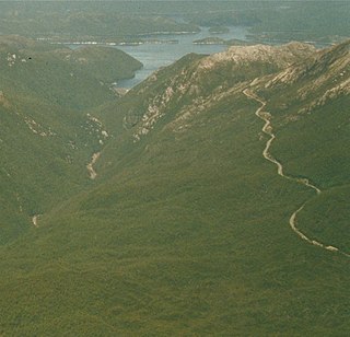
The West Coast Range is a mountain range located in the West Coast region of Tasmania, Australia.
Lake Margaret is a concrete-faced gravity dam with an uncontrolled spillway across the Yolande River, located on the north side of Mount Sedgwick, in the West Coast Range, West Coast of Tasmania, Australia.
Mount Read is a mountain located in the West Coast region of Tasmania, Australia, and is at the north west edge of the West Coast Range.

Mount Owen is a mountain directly east of the town of Queenstown on the West Coast Range in Western Tasmania, Australia.
Mount Jukes is a mountain located on the Jukes Range, a spur off the West Coast Range, in the West Coast region of Tasmania, Australia.
The history of the railways on the West Coast of Tasmania has fascinated enthusiasts from around the world, because of the combination of the harsh terrain in which the railways were created, and the unique nature of most of the lines.

Mount Murchison is a mountain on the West Coast Range, located in the West Coast region of Tasmania, Australia.
Mount Geikie is a mountain in the West Coast Range of Western Tasmania, Australia.

The Wee Georgie Wood Railway is a 2 ft narrow gauge tourist tramway running from Tullah, on a 1.9 km (1.2 mi) short track by the edge of Lake Rosebery in the West Coast Municipality of Tasmania.
Tullah is a town in the northern part of the West Coast Range, on the west coast of Tasmania, about 111 km south of Burnie. The town has a population of approximately 202 people.
Lake Dora is a 48-hectare (120-acre) lake and also short-lived mining area of the late 1890s located in the West Coast Range of Western Tasmania, Australia. It has a surface level of 756 metres (2,480 ft) AHD .
Lake Bassano was a proglacial lake that formed in the Late Pleistocene during the deglaciation of south-central Alberta by the impoundment of a re-established drainage system and addition of glacial meltwater. It is associated with the development of through-flowing drainage within the Red Deer River basin in particular, and the South Saskatchewan drainage network in general. Approximately 7,500 square kilometres (2,900 sq mi) of the Bassano basin is covered with lacustrine sediments. These sediments are bordered by the topographically higher Buffalo Lake Moraine to the west, the Suffield Moraine to the east and the Lethbridge Moraine to the south.
The Anthony Road is a major B Route in Western Tasmania, running from the Murchison Highway (A10) at Tullah to the Zeehan Highway (A10) north of Queenstown.
Lake Westwood is a 35-hectare (86-acre) glacial lake in the Tyndalls peaks to the east of Mount Read, in the West Coast Range, West Coast of Tasmania.
Neopluvial is a term referring to a phase of wetter and colder climate that occurred during the late Holocene in the Western United States. During the Neopluvial, water levels in a number of now-dry lakes and closed lakes such as the Great Salt Lake rose and vegetation changed in response to increased precipitation. The event was not exactly synchronous everywhere, with neopluvial lake-level rises occurring between 6,000 and 2,000 years ago. It is correlative to the Neoglacial period.
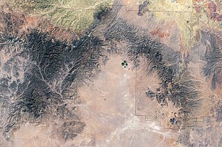
Lake San Agustín is a former lake in New Mexico, which developed as a pluvial lake in the Plains of San Agustín during Pleistocene glacial periods. During its highstands it covered an area of 1,200 square kilometres (460 sq mi) with a maximum depth of 70 metres (230 ft), and split into several separate lakes while drying out. The lake last appeared during the last glacial maximum (LGM) and dried out at the beginning of the Holocene, with the last remnant disappearing about 5,000 years ago.
