It is commonly used as a bypass of Rosebery for people travelling south to Queenstown and beyond or for people travelling north to Tullah and beyond.
The Anthony Road is the only road from which all major peaks of the Cradle Mountain-Lake St Clair reserve can be seen. It provides access to several classic walks: Mt Murchison, the Dora Plateau and the Tyndall Range.[1]
It runs close to natural and man made lakes in the upper reaches of the Murchison River catchment of the Pieman River power scheme. Lakes include Lake Plimsoll, Lake Selina, and Lake Westwood. It also goes close to the base of Mount Murchison.
The Lyell Highway is a highway in Tasmania, running from Hobart to Queenstown. It is the one of two transport routes that passes through the West Coast Range, the other being the Anthony Road.
The West Coast Range is a mountain range located in the West Coast region of Tasmania, Australia.
The West Coast of Tasmania is mainly isolated rough country, associated with wilderness, mining and tourism. It served as the location of an early convict settlement in the early history of Van Diemen's Land, and contrasts sharply with the more developed and populous northern and eastern parts of the island state.
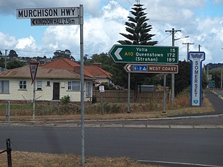
The Murchison Highway is a highway located in the West Coast region of Tasmania, Australia. The 147-kilometre (91 mi) highway runs generally north–south, with Somerset, near Burnie, as its northern terminus and Zeehan as its southern terminus. The highway was opened on 13 December 1963. Part of the highway from Waratah to Burnie was known as the Waratah Highway until 1973.
The mines of the West Coast of Tasmania have a rich historical heritage as well as an important mineralogical value in containing or having had found, specimens of rare and unusual minerals. Also, the various mining fields have important roles in the understanding of the mineralization of the Mount Read Volcanics, and the occurrence of economic minerals.
The Strahan–Zeehan Railway, also known as the 'Government Railway', was a railway from Strahan to Zeehan on the west coast of Tasmania.
Mount Tyndall is a mountain that is part of the Tyndall Range, a spur off the West Coast Range, located in the Western region of Tasmania, Australia.
The Henty River is a perennial river in the West Coast region of Tasmania, Australia. The river generally lies north of Queenstown and south of Zeehan.
Mount Murchison is a mountain on the West Coast Range, located in the West Coast region of Tasmania, Australia.
Mount Geikie is a mountain in the West Coast Range of Western Tasmania, Australia.
The Henty Gold Mine is located at the head of the Henty River on the edge of the West Coast Range in Western Tasmania. It is approximately 30 km north of Queenstown. It is east of Zeehan and south of Rosebery. It can be reached by the Hydro-built road that passes between the Henty River and Tullah.
The Wee Georgie Wood Railway is a 2 ft narrow gauge tourist tramway running from Tullah, on a 1.9 km (1.2 mi) short track by the edge of Lake Rosebery in the West Coast Municipality of Tasmania.
Tullah is a town in the northern part of the West Coast Range, on the west coast of Tasmania, about 111 km south of Burnie. The town has a population of approximately 160 people.
Lake Selina is a natural glacial lake located to the east of Mount Read, in the West Coast Range, on the west coast of Tasmania, Australia.
Lake Westwood is a 35-hectare (86-acre) glacial lake in the Tyndalls peaks to the east of Mount Read, in the West Coast Range, West Coast of Tasmania.
The Tyndall Range, commonly called The Tyndalls, is a mountain range that is part of the West Coast Range located in the Western region of Tasmania, Australia.
The 2016 Tasmanian Bushfires were a large series of bushfires in Tasmania which started in January 2016 throughout the state, and continued into February 2016, with considerable damage to fire sensitive areas in the Central Highlands, West Coast and South West regions. By autumn 2016, no bushfires were reported within the state.
Zeehan Highway is a road between Zeehan and Queenstown in Western Tasmania.
Queenstown to Strahan road is a road that connects Queenstown with Strahan in Western Tasmania.
Zeehan-Strahan Road is a road that links Strahan with Zeehan in Western Tasmania.
This page is based on this Wikipedia article Text is available under the CC BY-SA 4.0 license; additional terms may apply. Images, videos and audio are available under their respective licenses.