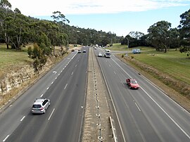
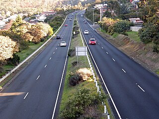
The Midland Highway is one of Tasmania's major inter-city highways, running for 176 kilometres (109 mi) between Hobart and Launceston. It is part of the AusLink National Network and is a vital link for road freight to transport goods to and from the two cities. It represents a major north–south transportation corridor in Tasmania and has the route 1 designation as part of the National Highway. The highway consists of various traffic lane arrangements, the most common being two lanes – one in each direction, with overtaking options and at-grade intersections. At both the Launceston and Hobart sections of the highway there are small portions of grade-separated dual carriageway.

The Brooker Highway is a highway in the State of Tasmania, Australia. As one of Hobart's 3 major radials, the highway connects traffic from the Hobart city centre with the northern suburbs and is the major road connection to the cities and towns of Northern Tasmania. With an AADT of 48,000, the highway is one of the busiest in Tasmania. The Brooker Highway has recently been declared part of the National Highway.

The Tasman Highway is a highway in Tasmania, Australia. Like the Midland Highway, it connects the major cities of Hobart and Launceston – however it takes a different route, via the north-eastern and eastern coasts of the state. The Highway also acts as a major commuter road to Hobart residents living on the eastern side of the Derwent River. The designation "Tasman Highway" arises from its location facing the Tasman Sea – named, like the state itself, after Abel Tasman. The highway is one of the longest in Tasmania - 410 km (250 mi), with an average traveling time of 41⁄2 hours.

Davey Street a major one way street passing through the outskirts of the Hobart City Centre in Tasmania, Australia. Davey street is named after Thomas Davey, the first Governor of Van Diemen's Land. The street forms a one-way couplet with nearby Macquarie Street connecting traffic from the Southern Outlet in the south with traffic from the Tasman Highway to the east and the Brooker Highway to the north of the city. With annual average daily traffic of 37,200, the road is one of the busier streets in Hobart.
Port Wakefield Highway is an important South Australian highway, connecting Adelaide to the Yorke Peninsula, Port Augusta, northern and western South Australia, the Northern Territory and Western Australia. It is designated National Highway A1 and a part of the National Highway. It is named after Port Wakefield, the first government town north of Adelaide.

The West Coast of Tasmania is mainly isolated rough country, associated with wilderness, mining and tourism. It served as the location of an early convict settlement in the early history of Van Diemen's Land, and contrasts sharply with the more developed and populous northern and eastern parts of the island state.
South Road - and its southern section as Main South Road outside of Adelaide - is a major north–south conduit connecting Adelaide and the Fleurieu Peninsula, in South Australia. It is one of Adelaide's most important arterial and bypass roads. As South Road, it is designated part of route A2 within suburban Adelaide, and as Main South Road, it is designated part of routes A13 and B23.
Macquarie Street a major one way street passing through the outskirts of the Hobart City Centre in Tasmania, Australia. Macquarie street is named after Lachlan Macquarie, who oversaw the planning of Hobart’s inner city grid layout. The street forms a One-way couplet with nearby Davey Street connecting traffic from the Southern Outlet in the south with traffic from the Tasman Highway to the east and the Brooker Highway to the north of the city. With annual average daily traffic of 28,500, the road is one of the busier streets in Hobart.
Arizona State Route 143, also known as SR 143 and the Hohokam Expressway, is a north–south and access-controlled freeway in Maricopa County, Arizona, that runs from a junction with Interstate 10 at 48th Street in Phoenix to McDowell Road. The only other major junction along the 3.93-mile (6.32 km) route is with Loop 202, which is located one half-mile south of McDowell Road and the northern terminus.
The Arthur Highway (A9) is a Tasmanian highway which runs from Sorell in the near south to Port Arthur in the far south-east.
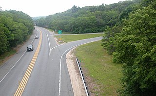
A two-lane expressway or two-lane freeway is an expressway or freeway with only one lane in each direction, and usually no median barrier. It may be built that way because of constraints, or may be intended for expansion once traffic volumes rise. The term super two is often used by roadgeeks for this type of road, but traffic engineers use that term for a high-quality surface road. Most of these roads are not tolled.
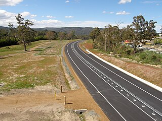
The Kingston Bypass is a A$41 million, 2.8-kilometre-long (1.7 mi) highway bypassing the southern Hobart community of Kingston, Tasmania. The proposal of a bypass was originally published in the Hobart Area Transportation Study during 1965. The bypass was completed in 2011, after the need to such a road was realised several years earlier when the Channel Highway reached an 18,000 AADT. Construction of the Bypass was made possible by an A$15 million pledge for the project, made by the Australian Labor Party during the 2007 federal election campaign. During construction total cost of the bypass blew out from the original estimate of $30 million to over $41 million.
The South Arm Highway is a highway serving the southern suburbs of Hobart, on the eastern shore of the River Derwent in Tasmania, Australia. The highway is a major trunk road that carries heavy commuter traffic south from the Eastern Outlet to Howrah and Rokeby. As one of the Tasman Highway's principle Feeders and one of the eastern shore's major transport corridors, The South Arm Highway facilitates the movement of traffic between the suburbs and satellite communities to the south with the city centre and ultimately, other major cross city highways. With annual average daily traffic (AADT) of 17,000, the highway is considered a major traffic corridor within Hobart. The designation "South Arm Highway" arises from its journey south to South Arm.
The city of Hobart, Tasmania is served by a wide variety of transport. While the city's main form of transport is private transport on the road network, transport is also available by bus, ferry and aircraft. A suburban train service operated between Hobart and Brighton from the 1870s until 31 December 1974. There has been, however, talk in recent years of reinstating a train service in the northern suburbs.

The Southern Transport Investment Program is a road and rail transport plan for the northern outskirts of Hobart instituted in 2007 by the Tasmanian state government. It outlines most prominently an extensive upgrade of the Midland Highway, including the Brighton Bypass, the Bagdad Bypass and the replacement of the Bridgewater Bridge. The plan also outlines the construction of the Brighton Transport Hub and various rail alignment improvements to the Main North/South Line.
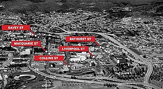
The Hobart Bypass is a proposed concept to bypass the Central Business District of Hobart, Tasmania. Currently, through traffic travels from the Tasman/Brooker Highways down the one-way Davey/Macquarie couplet to the Southern Outlet. As well as traffic concerns, there is also a call to build the bypass on the grounds that the current traffic arrangement cuts the central business district off from Hobart's waterfront.

The Hobart Area Transportation Study was a comprehensive transport plan released in 1965 for the purpose of examining the transport needs of the Australian Hobart metropolitan area over the proceeding 20 years. The study predicted the majority of the proposed traffic corridors would need to be operational by the 1985 target year.