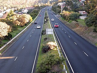
The Brooker Highway is a highway in the State of Tasmania, Australia. As one of Hobart's 3 major radials, the highway connects traffic from the Hobart city centre with the northern suburbs and is the major road connection to the cities and towns of Northern Tasmania. With an AADT of 48,000, the highway is one of the busiest in Tasmania. The Brooker Highway has recently been declared part of the National Highway.

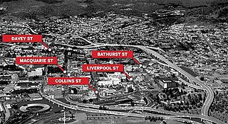
Davey Street a major one way street passing through the outskirts of the Hobart Central business district in Tasmania, Australia. Davey street is named after Thomas Davey, the first Governor of Van Diemen's Land. The street forms a One-way couplet with nearby Macquarie Street connecting traffic from the Southern Outlet in the south with traffic from the Tasman Highway to the east and the Brooker Highway to the north of the city. With Annual average daily traffic of 37,200, the road is one of the busier streets in Hobart.

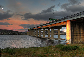
The Bowen Bridge is a four-lane road bridge crossing the Derwent River in Tasmania, Australia. The Bridge lies on the river about half way between the Tasman Bridge and the Bridgewater Bridge. The Bridge links the East Derwent Highway with the Brooker Highway at Glenorchy some 10 kilometres (6.2 mi) from Hobart. The Bowen Bridge was built with Federal funds following the collapse of the Tasman Bridge in 1975. The bridge cost $49 million to construct and was officially opened on 23 February 1984. The Bowen Bridge was built with the intention of assisting the commuters of Hobart, should something happen to the Tasman Bridge. The bridge is named after John Bowen who settled the first European Colony in Tasmania at Risdon Cove, which later would be moved to the other side of the Derwent to form Hobart.

The Bridgewater Bridge and Causeway spans the Derwent River in Tasmania, Australia between Bridgewater and Granton. It consists of a vertical lift bridge and a specially-built causeway connecting the bridge to the east bank of the river. It accommodates a two-lane highway, a single track railway and, on the bridge section, a footpath. As the bridge is the major connector of the Midland Highway on the eastern shore and the Brooker Highway on the western, the lifting of the bridge can cause considerable traffic delays, depending on the time of day and season.

The Tasman Bridge disaster occurred on the evening of 5 January 1975, in Hobart, the capital city of Australia's island state of Tasmania, when a bulk ore carrier travelling up the Derwent River collided with several pylons of the Tasman Bridge, causing a large section of the bridge deck to collapse onto the ship and into the river below. Twelve people were killed, including seven crew on board the ship, and the five occupants of four cars which fell 45 m (150 feet) after driving off the bridge. This severed Hobart from its eastern suburbs, and the loss of the main road connection had a social and economic impact.
Macquarie Street a major one way street passing through the outskirts of the Hobart Central business district in Tasmania, Australia. Macquarie street is named after Lachlan Macquarie, who oversaw the planning of Hobart’s inner city grid layout. The street forms a One-way couplet with nearby Davey Street connecting traffic from the Southern Outlet in the south with traffic from the Tasman Highway to the east and the Brooker Highway to the north of the city. With annual average daily traffic of 28,500, the road is one of the busier streets in Hobart.

SS Lake Illawarra was a handysize bulk carrier of 7,274 tons in the service of the Australian National Line shipping company. This ship is known for causing the Tasman Bridge disaster when she collided with pylon 19 of Hobart's giant high concrete arch style Tasman Bridge on the evening of 5 January 1975 at 9.27 pm, resulting in the deaths of 12 people.
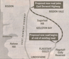
The Eastern Ring Road is a proposed Link between the South Arm Highway and the East Derwent Highway, within the greater area of Hobart, Tasmania. The idea behind the proposal is to see a continuous route from South Arm to the Bowen Bridge without the need to travel via the Tasman Highway. The proposal would see Flagstaff Gully Road extended to the north to meet up with the East Derwent Highway. The idea was first investigated in 1995 when Ratio Consultants did a study on the proposed link. They considered four options for the link, the most popular choice would connect to the East Derwent Highway between Geilston Bay and Risdon Vale. Ratio concluded that constructing any of the options would most likely produce an unacceptable level of visual landscape, ecological, heritage and water quality impacts.
In 2005 during the Clarence City Council elections, Alderman Doug Chipman lobbied the State and Federal governments for the construction of the proposed link road.
A link road between the Tasman Highway and the Bowen Bridge will be needed in the future to take the pressure off Begonia Street, Gordons Hill Road, the East Derwent Highway, and the Tasman Bridge/Brooker Highway
— Doug Chipman

The East Derwent Highway is a highway in Hobart, Australia. The highway is a trunk road that carries heavy commuter traffic much like the Brooker Highway, except on the Eastern side of the River Derwent. The highway starts at the Lindisfarne Interchange near the eastern side of the Tasman Bridge, and travels north connecting to the Bowen Bridge and eventually leading to the Midland Highway at Bridgewater in the north.
The South Arm Highway is a highway serving the southern suburbs of Hobart, on the eastern shore of the River Derwent in Tasmania, Australia. The highway is a major trunk road that carries heavy commuter traffic south from the Eastern Outlet to Howrah and Rokeby. As one of the Tasman Highway's principle Feeders and one of the eastern shore's major transport corridors, The South Arm Highway facilitates the movement of traffic between the suburbs and satellite communities to the south with the city centre and ultimately, other major cross city highways. With annual average daily traffic (AADT) of 17,000, the highway is considered a major traffic corridor within Hobart. The designation "South Arm Highway" arises from its journey south to South Arm.
The Domain Highway is a highway in Tasmania, Australia. The highway acts as a link road connecting traffic between Hobart's two busiest highways; The Tasman Highway and the Brooker Highway while also bypassing the Hobart city centre. With recorded annual average daily traffic of 25,000, the single carriageway road is busier than some of Hobart's dual carriageway highways. Commencing at the Brooker Highway at Cornelian Bay and heading southeast between the banks of the Derwent River and the Domain and Botanical Gardens. The highway ends at the Tasman Highway, on the western approach of the Tasman Bridge.

Goodwood Road is a 4-lane link road that connects the City of Glenorchy to the City of Clarence in the greater area of Hobart, Tasmania. Using the Bowen Bridge the road travels over the River Derwent in semi-highway road layout. The Road starts 10 km north of the Hobart CBD near the Hobart Showground on the Brooker Highway at Glenorchy, from there it travels east past the Elwick Racecourse, over the Bowen Bridge and connects to the East Derwent Highway at Otago. While the route the road takes is used far less than other major arterial roads in Hobart, commuters often depend on the road when major incidents occur on other major roads throughout Hobart.
Elwick Road is a major arterial road that runs through the northern suburbs of Hobart, Tasmania. The Road is the major link road between the Main Road and the Brooker Highway that connects to Glenorchy. The Road Passes through residential areas.
The Kingston Interchange is a roundabout interchange which connects the Southern Outlet with the Huon Highway and the Channel Highway at Kingston, within the greater area of Hobart, Tasmania.

The Southern Transport Investment Program is a road and rail transport plan for the northern outskirts of Hobart instituted in 2007 by the Tasmanian state government. It outlines most prominently an extensive upgrade of the Midland Highway, including the Brighton Bypass, the Bagdad Bypass and the replacement of the Bridgewater Bridge. The plan also outlines the construction of the Brighton Transport Hub and various rail alignment improvements to the Main North/South Line.
The Hobart Bypass is a proposed concept to bypass the Central Business District of Hobart, Tasmania. Currently, through traffic travels from the Tasman/Brooker Highways down the one-way Davey/Macquarie couplet to the Southern Outlet. As well as traffic concerns, there is also a call to build the bypass on the grounds that the current traffic arrangement cuts the central business district off from Hobart's waterfront.

The Hobart Area Transportation Study was a comprehensive transport plan released in 1965 for the purpose of examining the transport needs of the Australian Hobart metropolitan area over the proceeding 20 years. The study predicted the majority of the proposed traffic corridors would need to be operational by the 1985 target year.
South Arm Peninsula is a peninsula that lies on the east side of the mouth of the River Derwent south of Hobart in Tasmania, Australia. The peninsula commences at Lauderdale and curves landward or inward on a narrow isthmus that has South Arm situated on the east side of the Derwent, across from Blackmans Bay on the west side. Opossum Bay is the northern most populated place on the northward curve.