Brighton Bypass

Last updated • 6 min readFrom Wikipedia, The Free Encyclopedia

Brighton Bypass

20-08-2013 Jordan River Levee Bridge(Pic-lab).jpg
General information
TypeHighway
Length9.5 km (5.9 mi)
Opened2012
Route number(s) Australian national highway 1.svg National Highway 1
(Bridgewater–Pontville)
Major junctions
South endAUS Alphanumeric Route B32.svg East Derwent Highway
(Bridgewater Roundabout)
 AUS Alphanumeric Route C321.svg Tea Tree Road for full list see Exits
North endAustralian national highway 1.svg Midland Highway (Pontville Roundabout)
Location(s)
Region Hobart
Major settlements Brighton, Pontville
Highway system

The Brighton Bypass is a A$191 million [1] [2] [3] north/south bypass of the Midland Highway diverting traffic away from the northern Hobart satellite suburbs of Brighton and Pontville. [4] [5] [6] Construction of the 9.5 km federally funded [7] dual carriageway started in April 2009, and was opened on 12 November 2012.

Contents

Route description

From a roundabout at the East Derwent Highway in Bridgewater, the bypass heads north as a controlled-access route. 400 to 800 metres (0.25 to 0.50 mi) north, near the southern edge of Brighton are separate northbound and then southbound interchanges with side roads, for access to the Brighton Transport Hub and nearby properties. After another one and a half kilometres (0.93 mi), the route veers to the north-east, and there is a trumpet interchange connecting to the bypassed section of Midland Highway. Skirting around the developed area of Brighton, the bypass crosses the Jordan River, and curves back to the north to a diamond interchange with Tea Tree Road. It continues north out of Brighton before curving back west to rejoin Midland Highway at a roundabout. [8]

History

The road that preceded the bypass was constructed in the early 19th century to facilitate communication between the north and the south of Tasmania. During the majority of that period Hobart inbound and outbound freight was always transferred via the Port of Hobart or the rail line. The motivation to construct the bypass was demonstrated 20 years ago, when freight in the Port of Hobart declined in favour transporting cargo to the ports to the north of the state. The Southern Railway Line had become outdated due to years of poor maintenance and was no longer an efficient alternative to road transport.

Planning

In 2007, the Lennon government released the Southern Transport Investment Program, a comprehensive Transport study which marked a clear plan and timetable for constructing the bypass. The bypass is designed as a fully grade separated Dual carriageway Highway from the Bridgewater roundabout to just north of Pontville. The sweeping Bypass has been designed to be safe and provide a high level of service. Completion of the bypass also facilitates a seamless connection to the Brighton Transport Hub and provided an opportunity in its construction to realign the south line in certain sections. After intense lobbying on behalf of the State government [9] [10] and councils involved, the construction of the bypass became a Federal election issue, with both major parties pledging financial support towards its construction.

Construction

In January 2009 the Rudd Government approved 10.5 million dollars [7] to start excavation work on the Bypass, [5] with the state government describing it as "the biggest infrastructure project in southern Tasmania". [5] The new dual carriageway road will be built concurrently with the $79 million southern transport hub. The project was fast-tracked as part of the Federal Government's economic stimulus package. Funds from the Rudd Government are paying for the Brighton bypass, while the Tasmanian government is funding the road and rail freight transport interchange at Brighton.

Construction commenced in April 2009 - a month early. During May 2010, Lara Giddings announced the opening of Glenstone Road. [11] Constructed as the Brighton Transport Hub Link Road, the road has detoured the traffic flow around the Midland Highway in the area of the Brighton Industrial Estate to enable construction of the bypass in that area.

25-01-2012-Griggs-Road-Pano.jpg
The bypass under construction. The Jordan River Levee can be seen to the left while the Griggs Road overpass is to the right

Opening

The southernmost 2 km stretch of the Brighton Bypass opened to the public on Monday 13 December 2010, while the official opening of the Bypass was on Monday 12 November 2012 [1] - four months ahead of schedule. [1] One year after opening, the traffic volume on the Midland Highway in Brighton had decreased by 42%, from close to 11,000 vehicles a day to less than 6400. [12]

Aboriginal heritage issues

The Brighton Bypass remains controversial because of the Tasmanian government's refusal to properly investigate the proposed road corridor for Aboriginal sites prior to construction. In September 2009 Aboriginal locals conducted a protest at the Jordan River crossing of the proposed road, stating that construction would destroy an Aboriginal site of potential world significance. [13] Over the next few days, twenty protesters were arrested while attempting to halt work on the bypass. [14] [15] [16] Local Aboriginal activist Michael Mansell called for the bypass to be scrapped stating that to continue "would be cultural vandalism, on an extreme scale". [17] In February 2010, the Aboriginal community gave archaeologists permission to excavate the site, [18] [19] after the state government agreed to consult more closely with it about the cultural values of the site. [18] [19]

Jordan River Levee

The Jordan River Levee bridge under construction 22-07-2012jrlbridge03.JPG
The Jordan River Levee bridge under construction
Protests taking place on 15 April 2011 Jordan-river-levee-protest4.jpg
Protests taking place on 15 April 2011

In March 2010, with construction well advanced an archaeological excavation of the Jordan River Levee uncovered stone tools dating back more than 30,000 years. [20] [21] [22] In response, the Department of Primary Industries, Parks, Water and Environment (DPIPWE) placed construction on hold in that section of the project as well as commissioning peer reviews of the findings which were inconsistent with the findings of the original report. [23] [24] There is a range of opinions on the merits of both the original study and the peer reviews. [25]

The government estimated the cost of the bridge at $5 – $10 million and claimed that its construction would protect the site. [20] The local Aboriginal community rejected the bridge proposal and immediately appealed to the Minister of Heritage, David O'Byrne. Over the following weeks, representatives of the Aboriginal community negotiated with the government over the site. They suggested the government re-route funds from their failed Tarkine road project into diverting the bypass around the Levee. [26] [27] They proposed to have the road follow the train tracks before crossing the Jordan River. The government rejected this idea, as funding for the Tarkine road was designated for the north-west of the state and creating a diversion in the sweeping bypass would lower the speed limit, create unsafe geometry, and be almost impossible to build without altering the site of the rail bridge. [26] The Aboriginal community then released an amended plan proposing to have the highway cut through the southern tip of the Brighton Suburb. [26] The government rejected this proposal also, stating that the amended plans would cost an additional $60 million and not address all the safety concerns. [26]

On 17 December 2010, Tasmanian Aboriginals set up camp on the levee and vowed not to budge as bulldozers rolled in. [28] They named the levee "Kutalayna". [29]

On 25 January 2011 Federal Minister for Infrastructure and Transport Anthony Albanese announced his support for the state government's preferred crossing of the Jordan River after the Independent review launched by the Federal government was finalised. [30] The report's key findings stated that the alternative bridging options would increase the overall cost of the bypass by at least $127 million and delay its completion by up to 4 years while new planning and environmental approvals were sought. It also noted that changing the route of the bypass would add between $82 and $140 million to the overall cost of the project. [30]

On 6 March 2011, the protesters attracted 200 people to an open day held at Camp Kutalayna in a show of community support. [31] Visitors were given a tour of the area and told of its cultural and historical significance.

On 11 April 2011, Minister for Environment, Parks and Heritage, Brian Wightman approved a construction environmental management plan enabling construction to start on the Bridge. [28] The following day The Department of Infrastructure, Energy and Resources said it was about to start constructing fences around the boundary of the construction site. [32] The department said they would provide a fenced "safe zone" for Aboriginal protesters. They also said they were prepared for confrontation with protesters at the Jordan River levee site, but were hopeful protests would not escalate to a point where force would be required. [32]

Exits

Most of the road is in the Brighton Council local government area, with the northern tip and interchange falling within the Southern Midlands Council.

Locationkm [8] miDestinationsNotes
Bridgewater 00.0Australian national highway 1.svgAUS Alphanumeric Route B32.svg Midland Highway (National Highway 1) southwest / East Derwent Highway (B32) southeast  Hobart, Lindisfarne Roundabout; southern terminus
Brighton 0.4–
0.8
0.25–
0.50
Brighton Transport HubSeparate access for northbound and southbound traffic
2.41.5Midland Highway north  Brighton, Brighton Transport Hub Trumpet interchange
5.83.6AUS Alphanumeric Route C321.svg Tea Tree Road (C321) – Brighton, Triabunna Diamond interchange
Pontville 9.55.9Australian national highway 1.svg Midland Highway (National Highway 1 north)  Pontville, Launceston Roundabout; northern terminus
1.000 mi = 1.609 km; 1.000 km = 0.621 mi

See also

Australia road sign W5-29.svg   Australian Roadsportal

Related Research Articles

<span class="mw-page-title-main">Hume Highway</span> Major national highway in Australia

Hume Highway, inclusive of the sections now known as Hume Freeway and Hume Motorway, is one of Australia's major inter-city national highways, running for 840 kilometres (520 mi) between Melbourne in the southwest and Sydney in the northeast. Upgrading of the route from Sydney's outskirts to Melbourne's outskirts to dual carriageway was completed on 7 August 2013.

King's Highway 401, commonly referred to as Highway 401 and also known by its official name as the Macdonald–Cartier Freeway or colloquially referred to as the four-oh-one, is a controlled-access 400-series highway in the Canadian province of Ontario. It stretches 828 kilometres (514 mi) from Windsor in the west to the Ontario–Quebec border in the east. The part of Highway 401 that passes through Toronto is North America's busiest highway, and one of the widest. Together with Quebec Autoroute 20, it forms the road transportation backbone of the Quebec City–Windsor Corridor, along which over half of Canada's population resides. It is also a Core Route in the National Highway System of Canada. The route is maintained by the Ministry of Transportation of Ontario (MTO) and patrolled by the Ontario Provincial Police. The speed limit is 100 km/h (62 mph) throughout its length, with the only exceptions the posted 80 km/h (50 mph) limit westbound in Windsor and in most construction zones, along with a 110 km/h (68 mph) speed limit between Windsor and Tilbury.

<span class="mw-page-title-main">A14 road (England)</span> Major road in England

The A14 is a major trunk road in England, running 127 miles (204 km) from Catthorpe Interchange, a major intersection at the southern end of the M6 and junction 19 of the M1 in Leicestershire to the Port of Felixstowe, Suffolk. The road forms part of the unsigned Euroroutes E24 and E30. It is the busiest shipping lane in East Anglia carrying anything from cars to large amounts of cargo between the UK and Mainland Europe.

<span class="mw-page-title-main">Bridgewater, Tasmania</span> Suburb of Hobart, Tasmania, Australia

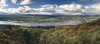
Bridgewater is a suburb of Hobart, Tasmania. Located approximately 19 km from the Hobart CBD, it is part of the northern suburbs area of Greater Hobart.

<span class="mw-page-title-main">Midland Highway (Tasmania)</span> Highway in Tasmania, Australia

The Midland Highway is one of Tasmania's major inter-city highways, running for 176 kilometres (109 mi) between Hobart and Launceston. It is part of the AusLink National Network and is a vital link for road freight to transport goods to and from the two cities. It represents a major north–south transportation corridor in Tasmania and has the route 1 designation as part of the National Highway. The highway consists of various traffic lane arrangements, the most common being two lanes – one in each direction, with overtaking options and at-grade intersections. At both the Launceston and Hobart sections of the highway there are small portions of grade-separated dual carriageway.

<span class="mw-page-title-main">Tasman Highway</span> Highway in Tasmania, Australia

The Tasman Highway is a highway in Tasmania, Australia. Like the Midland Highway, it connects the major cities of Hobart and Launceston – however it takes a different route, via the north-eastern and eastern coasts of the state. The Highway also acts as a major commuter road to Hobart residents living on the eastern side of the Derwent River. The designation "Tasman Highway" arises from its location facing the Tasman Sea – named, like the state itself, after Abel Tasman. The highway is one of the longest in Tasmania – 410 km (250 mi), with an average travelling time of 412 hours.

<span class="mw-page-title-main">Great Eastern Highway</span> Highway in Western Australia

Great Eastern Highway is a 590-kilometre-long (370 mi) road that links the Western Australian capital of Perth with the city of Kalgoorlie. A key route for road vehicles accessing the eastern Wheatbelt and the Goldfields, it is the western portion of the main road link between Perth and the eastern states of Australia. The highway forms the majority of National Highway 94, although the alignment through the Perth suburbs of Guildford and Midland, and the eastern section between Coolgardie and Kalgoorlie are not included. Various segments form parts of other road routes, including National Route 1, Alternative National Route 94, and State Route 51.

<span class="mw-page-title-main">Bridgewater Bridge (Tasmania)</span> Road and rail bridge in Tasmania, Australia

The Bridgewater Bridge is a combined road and rail bridge that carries the Midland Highway and South Railway Line across the Derwent River in Hobart, Tasmania, Australia. This steel truss vertical lift bridge and specially-built causeway connect the Hobart suburbs of Bridgewater and Granton. The bridge was completed in 1946 and accommodates a two-lane highway, a single track railway and a grade-separated footpath.

<span class="mw-page-title-main">Coolac, New South Wales</span> Town in New South Wales, Australia

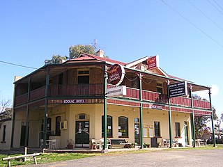
Coolac is a village in the Riverina region of New South Wales, Australia in Gundagai Council. At the 2016 census, Coolac had a population of 216.

Route 1 is a 120-kilometre (75 mi) long provincial highway that serves as the Prince Edward Island section of the Trans-Canada Highway. Route 1 traverses the southern shores of Prince Edward Island, from the Confederation Bridge in Borden-Carleton to the Wood Islands ferry dock, and bypasses the provincial capital, Charlottetown. It is an uncontrolled access 2-lane highway with a maximum speed limit of 90 km/h (55 mph), except within towns and urban areas.

<span class="mw-page-title-main">Kingston Bypass</span>

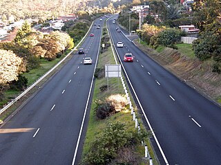
The Kingston Bypass is a A$41 million, 2.8-kilometre-long (1.7 mi) highway bypassing the southern Hobart community of Kingston, Tasmania. The proposal of a bypass was originally published in the Hobart Area Transportation Study during 1965. The bypass was completed in 2011, after the need to such a road was realised several years earlier when the Channel Highway reached an 18,000 AADT. Construction of the Bypass was made possible by an A$15 million pledge for the project, made by the Australian Labor Party during the 2007 federal election campaign. During construction total cost of the bypass blew out from the original estimate of $30 million to over $41 million.

<span class="mw-page-title-main">South Arm Highway</span> Highway in Tasmania, Australia

The South Arm Highway is a highway serving the southern suburbs of Hobart, on the eastern shore of the River Derwent in Tasmania, Australia. The highway is a major trunk road that carries heavy commuter traffic south from the Eastern Outlet to Howrah and Rokeby. As one of the Tasman Highway's principle Feeders and one of the eastern shore's major transport corridors, The South Arm Highway facilitates the movement of traffic between the suburbs and satellite communities to the south with the city centre and ultimately, other major cross city highways. With annual average daily traffic (AADT) of 17,000, the highway is considered a major traffic corridor within Hobart. The designation "South Arm Highway" arises from its journey south to South Arm.

<span class="mw-page-title-main">Hunter Expressway</span> Freeway in New South Wales, Australia

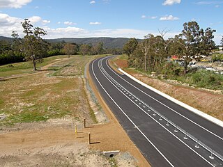
The Hunter Expressway is a 39.5-kilometre (24.5 mi) long controlled-access highway in New South Wales, Australia. It was previously known as the F3 to Branxton link or Kurri Kurri Corridor during the planning stage. It has two lanes in each direction, running generally north west from the Pacific Motorway at the Newcastle Link Road interchange to the eastern end of the Belford Bends Deviation on the New England Highway north of Branxton. The road allows traffic to bypass the Maitland area, Lochinvar, Greta and Branxton. The expressway opened on 22 March 2014.

<span class="mw-page-title-main">Southern Transport Investment Program</span> Transport plan in Tasmania, Australia

The Southern Transport Investment Program is a road and rail transport plan for the northern outskirts of Hobart instituted in 2007 by the Tasmanian state government. It outlines most prominently an extensive upgrade of the Midland Highway, including the Brighton Bypass, the Bagdad Bypass and the replacement of the Bridgewater Bridge. The plan also outlines the construction of the Brighton Transport Hub and various rail alignment improvements to the Main North/South Line.

<span class="mw-page-title-main">Brighton Transport Hub</span> Intermodal transport hub in Hobart, Tasmania

The Brighton Transport Hub is an intermodal transport hub in the northern Hobart suburb of Brighton operated by TasRail.

Mangalore is a rural locality in the local government areas (LGA) of Brighton and Southern Midlands in the Hobart and Central LGA regions of Tasmania. The locality is about 7 kilometres (4.3 mi) north of the town of Brighton. The 2016 census has a population of 422 for the state suburb of Mangalore. It is between the townships of Bagdad and Brighton, on the Midland Highway 32 km from the capital city of Hobart.

The Bagdad Bypass is a proposed bypass of the Midland Highway, through Bagdad, Tasmania. While not a new proposal, the idea began gaining momentum on the release of the Southern Transport Investment Program in 2007. The road will be initially constructed as a two-lane highway with extra earthworks undertaken to facilitate future duplication of the bypass. The road will be constructed as a grade separated highway and has been designed to seamlessly connect to the Brighton Bypass. In 2010, the Department of Infrastructure, Energy and Resources released 2 potential alignments for public comment. Neither design existed wholly within the existing proclaimed corridor and ultimately, a combination of the two designs was chosen to minimize intrusion into townships while at the same time keep construction costs to a minimum by diverting the future highway away from areas that would require significant earthworks.

<span class="mw-page-title-main">Jordan River (Tasmania)</span> River in Tasmania, Australia

The Jordan River is a perennial river located in the Midlands region of Tasmania, Australia.

The Perth Freight Link was a proposed $1.9 billion project in Perth, Western Australia to improve the road freight link between Kewdale and Fremantle Harbour. The project was announced by the state government in May 2014, but was cancelled following a change of government at the March 2017 state election.

References

  1. 1 2 3 "Brighton Bypass now open". The Mercury. 2012. Retrieved 15 November 2012.
  2. "Tasmania's Largest Road Infrastructure Project Completed". Investinaustralia.com. 2012. Retrieved 15 November 2012.
  3. "Bypass protest fails to disrupt opening". ABC News . 2012. Retrieved 15 November 2012.
  4. "Economic Stimulus Plan". Australian Government. 2009. Archived from the original on 14 May 2009. Retrieved 23 April 2009.
  5. 1 2 3 "Brighton bypass work starts". The Mercury. 2009. Retrieved 26 April 2009.
  6. "Mayor welcomes start on Brighton bypass". ABC news online. 2009. Retrieved 28 April 2009.
  7. 1 2 "Funding approved for early start on Brighton bypass". Australian Government. 2009. Archived from the original on 19 May 2009. Retrieved 9 January 2009.
  8. 1 2 Google (7 June 2014). "Brighton Bypass" (Map). Google Maps . Google. Retrieved 7 June 2014.
  9. "Prime Minister rejects pork-barrelling accusations". ABC News . 2007. Retrieved 3 May 2007.
  10. "Call for southern road funding". ABC News . 2007. Retrieved 29 June 2007.
  11. "Detour will avoid bypass site". The Mercury. 2009. Retrieved 29 May 2010.
  12. "Residents reclaim streets in style". Brighton Community News. 3 September 2013. Archived from the original on 4 February 2014. Retrieved 7 June 2014.
  13. "'Over our dead bodies': Aborigines rage against road". ABC News . 2009. Retrieved 18 September 2009.
  14. "Aborigines halt Brighton road work". ABC News . 2009. Retrieved 25 November 2009.
  15. "Roadworks dig finds millions of Aboriginal artifacts". ABC News . 2010. Retrieved 10 March 2010.
  16. "More arrests over Brighton bypass". ABC News . 2010. Retrieved 1 December 2009.
  17. "Aborigines label bypass work 'cultural vandalism'". ABC News . 2009. Retrieved 17 September 2009.
  18. 1 2 "Brighton Bypass impasse ends". ABC News . 2010. Retrieved 20 January 2010.
  19. 1 2 "Brighton bypass gets indigenous go-ahead". ABC News . 2010. Retrieved 3 February 2010.
  20. 1 2 "Bridge plan to protect Aboriginal heritage". ABC News . 2010. Retrieved 10 March 2010.
  21. "Brighton bypass significance confirmed". ABC News . 2010. Retrieved 26 April 2010.
  22. Robert Paton. "Draft Final Archaeology Report on the Test Excavations of the Jordan River Levee Site Southern Tasmania" (PDF). DPIWE. Archived from the original (PDF) on 1 October 2011. Retrieved 30 July 2011.
  23. Jim Allen; Jim Allen Archaeological Consultancies. "Peer Review of the Draft Final Archaeological Report on the Test Excavations of the Jordan River Levee Site Southern Tasmania (Robert Paton Archaeological Studies Pty Ltd, August 2010)" (PDF). Department of Primary Industries, Parks, Water and Environment (DPIPWE) . Retrieved 16 March 2011.
  24. Professor John Olley, Griffith University, Brisbane. "Peer review of the TASI 10757 Jordan River, Brighton, Tasmania: Luminescence Chronology (Cupper, May 2010)" (PDF). Department of Primary Industries, Parks, Water and Environment (DPIPWE) . Retrieved 16 March 2011.
  25. Rob Paton. "RESPONSES TO REVIEWS BY ALLEN AND RANSON OF THE DRAFT FINAL JORDAN RIVER LEVEE REPORT (ROBERT PATON ARCHAEOLOGICAL STUDIES PTY LTD)" (PDF). Retrieved 23 July 2011.
  26. 1 2 3 4 "Appendix 3 Investigation of Practical and Feasible Alternative Options" (PDF). Department of Infrastructure, Energy and Resources. 2010. Retrieved 26 April 2010.[ dead link ]
  27. "Brighton bypass re-route plan rejected". ABC News . 2010. Retrieved 4 June 2010.
  28. 1 2 "Bypass protest digs in". The Mercury. 2011. Retrieved 14 April 2011.
  29. "BEHIND ENEMY LINES: Seeing red as Brighton Bypass steams ahead". Tracker. 2011. Archived from the original on 24 June 2013. Retrieved 20 June 2013.
  30. 1 2 "Independent Review of Brighton Bypass Options Completed". Australian government. 2011. Archived from the original on 6 April 2011. Retrieved 14 April 2011.
  31. "Brighton bypass protesters recruit supporters". ABC News . 2011. Retrieved 14 April 2011.
  32. 1 2 "Protest 'safe zone' anger". The Mercury. 2011. Retrieved 14 April 2011.