
Hobart is the capital and most populous city of the island state of Tasmania, Australia. Located in Tasmania's south-east on the estuary of the River Derwent, it is the southernmost capital city in Australia. Despite containing nearly half of Tasmania's population, Hobart is the least-populated Australian state capital city, and second-smallest by population and area after Darwin if territories are taken into account. Its skyline is dominated by the 1,271-metre (4,170 ft) kunanyi / Mount Wellington, and its harbour forms the second-deepest natural port in the world, with much of the city's waterfront consisting of reclaimed land. The metropolitan area is often referred to as Greater Hobart, to differentiate it from the City of Hobart, one of the seven local government areas that cover the city. It has a mild maritime climate.

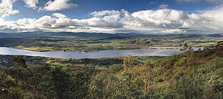
The River Derwent, also known as timtumili minanya in palawa kani, is a significant river and tidal estuary in Tasmania, Australia. It begins its journey as a freshwater river in the Central Highlands at Lake St Clair, descending over 700 metres (2,300 ft) across a distance of more than 200 kilometres (120 mi). At the settlement of New Norfolk in the Derwent Valley its waters become brackish, flowing through Hobart, the capital city of Tasmania, its seawater estuary eventually empties into Storm Bay and the Tasman Sea.
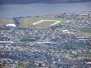
Glenorchy is a suburb of Hobart, Tasmania, Australia. Glenorchy is bound by the River Derwent to the east, Mount Wellington to the west, Hobart City to the south and Brighton to the north. The city officially begins at Creek Road New Town, in Hobart's northern suburbs, and includes, Moonah, Derwent Park, Lutana, Goodwood, Montrose, Rosetta, Berriedale, Chigwell, Claremont and Austins Ferry. It is the seat of the local government area of the same name, the City of Glenorchy.

Clarence City Council is a local government body in Tasmania, and one of the five municipalities that constitutes the Greater Hobart Area. The Clarence local government area has a population of 61,531, covering the eastern shore of the Derwent River from Otago to the South Arm Peninsula and the smaller localities of Cambridge, Richmond, and Seven Mile Beach.

New Town is a suburb of the city of Hobart, Tasmania, Australia, about 4 kilometres (2 mi) north of the central business district of Hobart. It is generally considered Hobart's oldest suburb, settled just a week after Sullivans Cove. It was historically the home of many of Hobart's wealthiest citizens, and New Town features a large number of grand residences, churches, and public buildings. The large farms were broken up following the world wars and it is now an inner city residential suburb. Many of its streets are lined with Federation style cottages. It is surrounded by the suburbs of North Hobart, Mount Stuart, Lenah Valley and Moonah, with the Queen's Domain just to the south-east. Most of the locality is within the Hobart local government area, with 2.5% within Glenorchy.

Sandy Bay is a prestigious suburb of the city of Hobart, Tasmania, Australia, located immediately south of the central business district and adjoining Battery Point. Sandy Bay is bordered by the Derwent River to the east and is known for its beaches, including Nutgrove Beach, Long Beach, and Lords Beach.
Claremont is a rural / residential locality in the local government areas (LGA) of Glenorchy (75%) and Derwent Valley (25%) in the Hobart and South-east LGA regions of Tasmania. The locality is about 6 kilometres (3.7 mi) north of the town of Glenorchy. The 2021 census recorded a population of 8,397 for the state suburb of Claremont.
Howrah is a residential locality in the local government area (LGA) of Clarence in the south-east region of Tasmania. The locality is about 5 kilometres (3.1 mi) south-east of the town of Rosny Park. The 2021 Census recorded a population of 9,545 for the suburb of Howrah. It is a suburb of the City of Clarence. It is east of Bellerive and north of Tranmere.

Montagu Bay is a suburb of Hobart, Tasmania, located in the City of Clarence on the eastern shore of the Derwent River, about four kilometres from the city centre of greater Hobart. It is a small primarily residential suburb located between Rosny, Rose Bay and Lindisfarne and is centred on a small bay of the same name, formerly known as Smelting Works Bay. The bay has a boat ramp and jetty, and is frequently filled with yachts and other vessels at anchor.

The Bridgewater Bridge is a combined road and rail bridge that carries the Midland Highway and South Railway Line across the Derwent River in Hobart, Tasmania, Australia. This steel truss vertical lift bridge and specially-built causeway connect the Hobart suburbs of Bridgewater and Granton. The bridge was completed in 1946 and accommodates a two-lane highway, a single track railway and a grade-separated footpath.

Taroona is a major residential suburb approximately 15 minutes drive from the centre of Hobart, Tasmania on the scenic route between Hobart and Kingston. Although on the edges of the City of Hobart, Taroona is actually part of the municipality of Kingborough. Taroona is bounded on the east by the Derwent River, and has several beaches along the shore, the main beaches with public access are Taroona Beach, Hinsby Beach and Dixons Beach. Past Hinsby Beach, the Alum Cliffs form a section of cliffed coast to the neighbouring suburb of Bonnet Hill.

BerriedaleBERR-ee-dayl is a residential suburb located in the northern part of Hobart, the capital city of Tasmania, Australia. Situated within the City of Glenorchy, it lies between the suburbs of Chigwell and Rosetta, approximately 15 kilometers from Hobart’s city centre. The suburb is most well-known for being home to the internationally acclaimed Museum of Old and New Art (MONA), which, along with the adjacent Moorilla Estate winery, has become a major cultural and tourist destination for Tasmania.
Gagebrook is a residential locality in the local government area (LGA) of Brighton in the Hobart LGA region of Tasmania, Australia. The locality is about 9 kilometres (5.6 mi) south of the town of Brighton. The 2016 census recorded a population of 1440 for the state suburb of Gagebrook. It is one of the northernmost suburbs of Hobart, located near the eastern shore of the Derwent River between the suburbs of Bridgewater and Old Beach.

Lutana is a residential locality in the local government area (LGA) of Glenorchy in the Hobart LGA region of Tasmania. The locality is about 3 kilometres (1.9 mi) south-east of the town of Glenorchy. The 2021 census recorded a population of 2,616 for the state suburb of Lutana. It is a suburb of Hobart. It is a large residential suburb located between the Brooker Highway and the River Derwent.

Granton is a rural residential locality in the local government areas (LGA) of Derwent Valley (80%) and Glenorchy (20%) in the South-east and Hobart LGA regions of Tasmania. The locality is about 9 kilometres (5.6 mi) north of the town of Glenorchy. The 2016 census recorded a population of 1736 for the state suburb of Granton. It is a suburb of Hobart. Rust Road is the approximate boundary between the two municipalities at Granton.

Rose Bay is a suburb of the City of Clarence in greater Hobart, capital city of Tasmania, Australia. Rose Bay is a small suburb, making up only approximately 0.9 square kilometres with nearly one fourth of that area (23.2%) being parkland. At the 2016 Census the suburb recorded a population of 1,102 people.

The Brighton Bypass is a A$191 million north/south bypass of the Midland Highway diverting traffic away from the northern Hobart satellite suburbs of Brighton and Pontville. Construction of the 9.5 km federally funded dual carriageway started in April 2009, and was opened on 12 November 2012.
Bridgewater High School was a government co-educational comprehensive secondary school located in Bridgewater, a suburb of Hobart, Tasmania, Australia.

Bridgewater Jerry is a fog formation that occasionally appears over the River Derwent in Hobart, Tasmania and down the Derwent Valley. It is named after the suburb of Bridgewater, and the word "jerry" may have come from convict slang for 'fog' or 'mist'. It was probably first described in 1821, when Governor Lachlan Macquarie was stranded at Austin's Ferry because of fog.
The Jordan River Learning Federation is a government co-educational comprehensive early learning centre, primary and secondary school, trade training centre, and school farm located in Bridgewater, a northern suburb of Hobart, Tasmania, Australia. Established in 1957 as Bridgewater High School, the school caters for approximately 300 students from birth to Year K and then to 12. The school is administered by the Tasmanian Department of Education.


