
Clarence City Council is a local government body in Tasmania, and one of the five municipalities that constitutes the Greater Hobart Area. The Clarence local government area has a population of 61,531, covering the eastern shore of the Derwent River from Otago to the South Arm Peninsula and the smaller localities of Cambridge, Richmond, and Seven Mile Beach.

Rosny is a suburb of the City of Clarence, part of the greater Hobart area, Tasmania, Australia. It is located on the eastern shore of the Derwent River, between the suburbs of Montagu Bay and Rosny Park, approximately 4 kilometres from Hobart's centre. Rosny is the residential part of its commercial namesake Rosny Park.
Howrah is a residential locality in the local government area (LGA) of Clarence in the Hobart LGA region of Tasmania. The locality is about 5 kilometres (3.1 mi) south-east of the town of Rosny Park. The 2021 Census recorded a population of 9,545 for the state suburb of Howrah. It is a suburb of the City of Clarence. It is east of Bellerive and north of Tranmere.
Tranmere is a rural residential locality in the local government area (LGA) of Clarence in the Hobart LGA region of Tasmania. The locality is about 9 kilometres (5.6 mi) south-east of the town of Rosny Park. The 2016 census recorded a population of 1701 for the state suburb of Tranmere. It is a suburb of greater Hobart. It is accessed from, and shares a border with Howrah, which lies to its north. Rokeby lies to its east.
Rokeby is a suburb of Hobart, capital of Tasmania, Australia on the eastern shore of the Derwent River. It is part of the City of Clarence local government area.

Moonah is a residential locality in the local government area (LGA) of Glenorchy in the Hobart LGA region of Tasmania. The locality is about 3 kilometres (1.9 mi) south-east of the town of Glenorchy. The 2016 census recorded a population of 5421 for the state suburb of Moonah. It is a suburb in the city of Hobart, located approximately 5 km north of the central business district of Hobart, and lying directly north of the inner city suburb New Town.
Chigwell is a residential locality in the local government area (LGA) of Glenorchy in the Hobart LGA region of Tasmania. The locality is about 6 kilometres (3.7 mi) north-west of the town of Glenorchy. The 2016 census recorded a population of 2002 for the state suburb of Chigwell.
Seven Mile Beach is a rural residential locality in the local government area (LGA) of Clarence in the Hobart LGA region of Tasmania. The locality is about 17 kilometres (11 mi) east of the town of Rosny Park. The 2016 census recorded a population of 1286 for the state suburb of Seven Mile Beach.
South Arm is a rural residential locality in the local government area of Clarence in the Hobart region of Tasmania. The locality is about 32 kilometres (20 mi) south-east of the town of Rosny Park. The 2016 census has a population of 880 for the state suburb of South Arm.
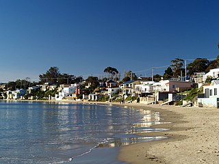
Opossum Bay is a rural residential locality in the local government area of Clarence in the Hobart region of Tasmania. The locality is about 37 kilometres (23 mi) south-east of the town of Rosny Park. The 2016 census has a population of 329 for the state suburb of Opossum Bay.

Dynnyrne is a residential locality in the local government area (LGA) of Hobart in the Hobart LGA region of Tasmania. The locality is about 3 kilometres (1.9 mi) south-west of the town of Hobart. The 2016 census recorded a population of 1577 for the state suburb of Dynnyrne.
Mornington is a residential locality in the local government area (LGA) of Clarence in the Hobart LGA region of Tasmania. The locality is about 4 kilometres (2.5 mi) north-east of the town of Rosny Park. The 2016 census recorded a population of 2265 for the state suburb of Mornington.

Rose Bay is a suburb of the City of Clarence in greater Hobart, capital city of Tasmania, Australia. Rose Bay is a small suburb, making up only approximately 0.9 square kilometres with nearly one fourth of that area (23.2%) being parkland. At the 2016 Census the suburb recorded a population of 1,102 people.
Mount Rumney is a semi-rural locality in the local government area (LGA) of Clarence in the Hobart LGA region of Tasmania. The locality is about 7 kilometres (4.3 mi) east of the town of Rosny Park. The 2016 census has a population of 267 for the state suburb of Mount Rumney. It is a suburb of Hobart.
Clarendon Vale is a rural residential locality in the local government area (LGA) of Clarence in the Hobart LGA region of Tasmania. The locality is about 10 kilometres (6.2 mi) south-east of the town of Rosny Park. The 2016 census recorded a population of 1267 for the state suburb of Clarendon Vale. It is a suburb of Hobart.
Sandford is a residential locality in the local government area (LGA) of Clarence in the Hobart LGA region of Tasmania. The locality is about 16 kilometres (9.9 mi) south-east of the town of Rosny Park. The 2016 census recorded a population of 1883 for the state suburb of Sandford.
Cremorne is a rural residential locality in the local government area (LGA) of Clarence in the Hobart LGA region of Tasmania. The locality is about 21 kilometres (13 mi) south-east of the town of Rosny Park. The 2016 census recorded a population of 526 for the state suburb of Cremorne. It is a town located on the South Arm Peninsula on the outskirts of Hobart.
Roches Beach is a rural residential locality in the local government area (LGA) of Clarence in the Hobart LGA region of Tasmania. The locality is about 19 kilometres (12 mi) east of the town of Rosny Park. The 2021 Census recorded a population of 220 for the state suburb of Roches Beach. It is a suburb of Hobart, between Lauderdale and Acton Park.
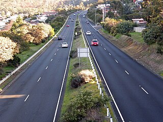
The South Arm Highway is a highway serving the southern suburbs of Hobart, on the eastern shore of the River Derwent in Tasmania, Australia. The highway is a major trunk road that carries heavy commuter traffic south from the Eastern Outlet to Howrah and Rokeby. As one of the Tasman Highway's principle Feeders and one of the eastern shore's major transport corridors, The South Arm Highway facilitates the movement of traffic between the suburbs and satellite communities to the south with the city centre and ultimately, other major cross city highways. With annual average daily traffic (AADT) of 17,000, the highway is considered a major traffic corridor within Hobart. The designation "South Arm Highway" arises from its journey south to South Arm.
Bayview Secondary College, formerly known as Rokeby High School, is a government comprehensive secondary school located in Rokeby, a suburb of Hobart, Tasmania, Australia. Established in 1980, the school caters for approximately 300 students from Years 7 to 12. The school is administered by the Tasmanian Department of Education. It received its current name in 2016.


