
Hobart is the capital and most populous city of the Australian island state of Tasmania. Home to almost half of all Tasmanians, it is the least-populated Australian state capital city, and second-smallest if territories are taken into account, before Darwin, Northern Territory. Hobart is located in Tasmania's south-east on the estuary of the River Derwent, making it the most southern of Australia's capital cities. Its skyline is dominated by the 1,271-metre (4,170 ft) kunanyi/Mount Wellington, and its harbour forms the second-deepest natural port in the world, with much of the city's waterfront consisting of reclaimed land. The metropolitan area is often referred to as Greater Hobart, to differentiate it from the City of Hobart, one of the five local government areas that cover the city. It has a mild maritime climate.
Councils of Tasmania are the 29 administrative districts of the Australian state of Tasmania. Local government areas (LGAs), more generally known as councils, are the tier of government responsible for the management of local duties such as road maintenance, town planning and waste management.

The Tasman Peninsula, officially Turrakana / Tasman Peninsula, is a peninsula located in south-east Tasmania, Australia, approximately 75 km (47 mi) by the Arthur Highway, south-east of Hobart.
Kingston is a town on the outskirts of Hobart, Tasmania, Australia. Nestled 12 km south of the city between and around several hills, Kingston is the seat of the Kingborough Council, and today serves as the gateway between Hobart and the D'Entrecasteaux Channel region, which meets the Derwent River nearby. It is one of the fastest-growing regions in Tasmania. The Kingston-Huntingfield statistical area had an estimated population of 11,200 in June 2012.

Clarence City Council is a local government body in Tasmania, and one of the five municipalities that constitutes the Greater Hobart Area. The Clarence local government area has a population of 61,531, covering the eastern shore of the Derwent River from Otago to the South Arm Peninsula and the smaller localities of Cambridge, Richmond, and Seven Mile Beach.
Kingborough Council is a local government body in Tasmania, and one of the five municipalities that constitutes the Greater Hobart Area. Kingborough is classified as an urban local government area and has a population of 37,734, it covers the transition from the southern urban areas of Hobart through Kingston, as well as encompassing Bruny Island.

Blackmans Bay is a coastal suburb of Kingborough Council, Tasmania, Australia. It forms part of the Kingston-Blackmans Bay urban area and is a satellite town of Greater Hobart. It borders Kingston Beach to the North, Maranoa Heights and the Peter Murrell Conservation Area to the West and Howden and Tinderbox to the South.

Sandy Bay is a suburb of the city of Hobart, Tasmania, Australia, located immediately south of the central business district, and adjoining the suburb of Battery Point. Sandy Bay is bounded on the east by the Derwent River, and has several beaches along the shore, the main beaches with public access are Short Beach, Nutgrove Beach, Long Beach and Lords Beach.

Orford is a village on the east coast of Tasmania, Australia 73 kilometres north-east of Hobart. It is the home of the joint champions of T20 Cricket in Tasmania. The village is centred on the mouth of the Prosser River, on the southern margin of a substantial coastal inlet called Prosser Bay. Beyond this bay are the waters of the Mercury Passage. At the 2006 census, Orford had a population of 553.

Taroona is a major residential suburb approximately 15 minutes drive from the centre of Hobart, Tasmania on the scenic route between Hobart and Kingston. Although on the edges of the City of Hobart, Taroona is actually part of the municipality of Kingborough. Taroona is bounded on the east by the Derwent River, and has several beaches along the shore, the main beaches with public access are Taroona Beach, Hinsby Beach and Dixons Beach. Past Hinsby Beach, the Alum Cliffs form a section of cliffed coast to the neighbouring suburb of Bonnet Hill.

The Huon Valley, or simply the Huon, is a valley and geographic area located in southern Tasmania, Australia. The largest town is Huonville, with other smaller towns spread across the area. It includes Australia's most southern permanent settlement at Southport. The Huon Valley Council area had a population of 15,140 in 2011. Famed for its apple growing, the Valley was first settled by British colonists in the 1820s; prior to settlement the Huon Valley area was inhabited by the Mouheneenner, Nuenonne, Mellukerdee and Lyluequonny people.
Bonnet Hill is a residential locality in the local government area (LGA) of Kingborough in the Hobart LGA region of Tasmania. The locality is about 2 kilometres (1.2 mi) east of the town of Kingston. The 2016 census recorded a population of 505 for the state suburb of Bonnet Hill.

Kingston Beach is a residential locality in the local government area (LGA) of Kingborough in the Hobart LGA region of Tasmania. The locality is about 2 kilometres (1.2 mi) south-east of the town of Kingston. The 2016 census recorded a population of 1990 for the state suburb of Kingston Beach.
Huntingfield is a residential locality in the local government area (LGA) of Kingborough in the Hobart LGA region of Tasmania. The locality is about 3 kilometres (1.9 mi) south-west of the town of Kingston. The 2016 census recorded a population of 428 for the state suburb of Huntingfield.
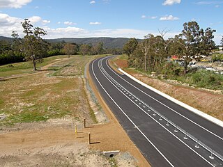
The Kingston Bypass is a A$41 million, 2.8-kilometre-long (1.7 mi) highway bypassing the southern Hobart community of Kingston, Tasmania. The proposal of a bypass was originally published in the Hobart Area Transportation Study during 1965. The bypass was completed in 2011, after the need to such a road was realised several years earlier when the Channel Highway reached an 18,000 AADT. Construction of the Bypass was made possible by an A$15 million pledge for the project, made by the Australian Labor Party during the 2007 federal election campaign. During construction total cost of the bypass blew out from the original estimate of $30 million to over $41 million.
The city of Hobart, Tasmania is served by a wide variety of transport. While the city's main form of transport is private transport on the road network, transport is also available by bus, ferry and aircraft. A suburban train service operated between Hobart and Brighton from the 1870s until 31 December 1974. There has been, however, talk in recent years of reinstating a train service in the northern suburbs.

The Hobart Area Transportation Study was a comprehensive transport plan released in 1965 for the purpose of examining the transport needs of the Australian Hobart metropolitan area over the proceeding 20 years. The study predicted the majority of the proposed traffic corridors would need to be operational by the 1985 target year.
Electrona is a rural residential locality in the local government area (LGA) of Kingborough in the Hobart LGA region of Tasmania. The locality is about 12 kilometres (7.5 mi) south of the town of Kingston. The 2016 census recorded a population of 364 for the state suburb of Electrona. It is a small residential area on the d'Entrecasteaux Channel in Southern Tasmania. It grew up around the Electrona Carbide Works which were established in 1909.
Tinderbox is a rural residential locality in the local government area of Kingborough in the Hobart region of Tasmania. It is located about 13 kilometres (8.1 mi) south of the town of Kingston. The 2016 census has a population of 394 for the state suburb of Tinderbox.
The Alum Cliffs are a section of cliffed coast facing the Derwent Estuary and Storm Bay along the suburbs of Taroona, Bonnet Hill, and Kingston Beach, Tasmania, Australia. Composed of Permian mudstone, the cliff formation stretches for 3.5 kilometres (2.2 mi) between Hinsby Beach and Tyndall Beach at Kingston Beach. The cliff face reaches heights of up to 30 metres (98 ft) above sea level and has vistas of the Derwent Estuary, Storm Bay, South Arm and Bruny Island.


