
Hobart ( HOH-bart; is the capital and most populous city of the island state of Tasmania, Australia. Located in Tasmania's south-east on the estuary of the River Derwent, it is the southernmost capital city in Australia. Despite containing nearly half of Tasmania's population, Hobart is the least-populated Australian state capital city, and second-smallest by population and area after Darwin if territories are taken into account. Its skyline is dominated by the 1,271-metre kunanyi / Mount Wellington, and its harbour forms the second-deepest natural port in the world, with much of the city's waterfront consisting of reclaimed land. The metropolitan area is often referred to as Greater Hobart, to differentiate it from the City of Hobart, one of the seven local government areas that cover the city. It has a mild maritime climate.

Surrey Hills is a suburb of Melbourne, Victoria, Australia, 11 km east of Melbourne's Central Business District, located within the Cities of Boroondara and Whitehorse local government areas. Surrey Hills recorded a population of 13,655 at the 2021 census.

Box Hill South is a suburb of Melbourne, Victoria, Australia, 14 km east of Melbourne's Central Business District, located within the City of Whitehorse local government area. Box Hill South recorded a population of 8,491 at the 2021 census.

Melton South is a suburb in Melbourne, Victoria, Australia, 37 km (23 mi) west of Melbourne's Central Business District, located within the City of Melton local government area. Melton South recorded a population of 11,362 at the 2021 census.

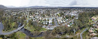
Sorell is a town in Tasmania, Australia, north-east of Hobart. It is located on the Tasman Highway at the junction with the Arthur Highway. Sorell is one of Tasmania's oldest towns, being first settled in 1808 as a small farming community and becoming an official township in 1821. At the 2006 census, Sorell had a population of 1,546, and at the 2011 census, a population of 2,476. and at the 2016 census, a population of 2,907.

New Town is a suburb of the city of Hobart, Tasmania, Australia, about 4 kilometres (2 mi) north of the central business district of Hobart. It is generally considered Hobart's oldest suburb, settled just a week after Sullivans Cove. It was historically the home of many of Hobart's wealthiest citizens, and New Town features a large number of grand residences, churches, and public buildings. The large farms were broken up following the world wars and it is now an inner city residential suburb. Many of its streets are lined with Federation style cottages. It is surrounded by the suburbs of North Hobart, Mount Stuart, Lenah Valley and Moonah, with the Queen's Domain just to the south-east. Most of the locality is within the Hobart local government area, with 2.5% within Glenorchy.
Euroa is a town in the Shire of Strathbogie in the north-east of Victoria, Australia. At the 2021 census, Euroa's population was 3,116.

Sandy Bay is a prestigious suburb of the city of Hobart, Tasmania, Australia, located immediately south of the central business district, and adjoining the suburb of Battery Point. Sandy Bay is bounded on the east by the Derwent River, and has several beaches along the shore, the main beaches with public access are Short Beach, Nutgrove Beach, Long Beach and Lords Beach.
Artarmon is a suburb on the lower North Shore of Sydney, in the state of New South Wales, Australia, 9 kilometres north-west of the Sydney central business district, in the local government area of the City of Willoughby.

Mount Nelson is a mountain suburb located on the southern boundary of the city of Hobart, Tasmania, Australia. Positioned to the south of Hobart's CBD, Mount Nelson varies in elevation with its summit reaching 351 metres (1,152 ft) above sea level, offering panoramic views of the scenic Derwent estuary and surrounds.

Moonah is a residential locality in the local government area (LGA) of Glenorchy in the Hobart LGA region of Tasmania. The locality is about 3 kilometres (1.9 mi) south-east of the town of Glenorchy. The 2016 census recorded a population of 5421 for the state suburb of Moonah. It is a suburb in the city of Hobart, located approximately 5 km north of the central business district of Hobart, and lying directly north of the inner city suburb New Town.

Bracknell is a rural locality and town in the local government areas of Meander Valley and Northern Midlands in the Launceston and Central regions of Tasmania. The locality is about 22 kilometres (14 mi) south-east of the town of Westbury. The 2016 census has a population of 459 for the state suburb of Bracknell.

Frankston South is a suburb in Melbourne, Victoria, Australia, 43 km south-east of Melbourne's Central Business District, located within the City of Frankston local government area. Frankston South recorded a population of 18,801 at the 2021 census.

Dynnyrne is a residential locality in the local government area (LGA) of Hobart in the Hobart LGA region of Tasmania. The locality is about 3 kilometres (1.9 mi) south-west of the town of Hobart. The 2016 census recorded a population of 1577 for the state suburb of Dynnyrne.
Rosny Park is a suburb of Hobart, Tasmania, located in the City of Clarence on the eastern shore of the Derwent River. It is about five kilometres from the city centre of Hobart. Rosny Park is the commercial twin of its residential namesake, Rosny.
Mount Stuart is a suburb of Hobart that lies on a ridge that extends from a foothill of Mount Wellington, known as Knocklofty.

Warrane is a suburb of Hobart, Tasmania, Australia, within the City of Clarence local government area. It is approximately 5 kilometres (3 mi) from Hobart's CBD. It is located between Rosny Park and Mornington and runs parallel to the Tasman Highway.
Bronte Park is a rural locality in the local government area (LGA) of Central Highlands in the Central LGA region of Tasmania. The locality is about 82 kilometres (51 mi) north-west of the town of Hamilton. The 2016 census recorded a population of 28 for the state suburb of Bronte Park. It is a locality on the Marlborough Highway at the southern edge of the Cradle Mountain-Lake St Clair National Park. It is located just north of the Lyell Highway and approximately halfway in between Hobart and Queenstown, and is also almost exactly in the geographic centre of the island.

Parattah is a small township in Tasmania, located approximately 6 kilometres (4 mi) southeast of the town of Oatlands. At the 2011 census, Parattah had a population of 360.
Marrawah is a small town in the north of the West Coast of Tasmania, Australia. Marrawah is located in the former shire of Wellington, now part of the Circular Head Council area. At the 2006 census, Marrawah had a population of 407.


