
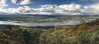
Hobart ( HOH-bart; is the capital and most populous city of the island state of Tasmania, Australia. Located in Tasmania's south-east on the estuary of the River Derwent, it is the southernmost capital city in Australia. Despite containing nearly half of Tasmania's population, Hobart is the least-populated Australian state capital city, and second-smallest by population and area after Darwin if territories are taken into account. Its skyline is dominated by the 1,271-metre kunanyi / Mount Wellington, and its harbour forms the second-deepest natural port in the world, with much of the city's waterfront consisting of reclaimed land. The metropolitan area is often referred to as Greater Hobart, to differentiate it from the City of Hobart, one of the seven local government areas that cover the city. It has a mild maritime climate.
Councils of Tasmania are the 29 administrative districts of the Australian state of Tasmania. Local government areas (LGAs), more generally known as councils, are the tier of government responsible for the management of local duties such as road maintenance, town planning and waste management.
Kingston is a town on the outskirts of Hobart, Tasmania, Australia. Nestled 12 km south of the city between and around several hills, Kingston is the seat of the Kingborough Council, and today serves as the gateway between Hobart and the D'Entrecasteaux Channel region, which meets the Derwent River nearby. It is one of the fastest-growing regions in Tasmania. The Kingston-Huntingfield statistical area had an estimated population of 13,473 in June 2021.
Kingborough Council is a local government body in Tasmania, and one of the five municipalities that constitutes the Greater Hobart Area. Kingborough is classified as an urban local government area and has a population of 37,734, it covers the transition from the southern urban areas of Hobart through Kingston, as well as encompassing Bruny Island.

Sandy Bay is a prestigious suburb of the city of Hobart, Tasmania, Australia, located immediately south of the central business district, and adjoining the suburb of Battery Point. Sandy Bay is bounded on the east by the Derwent River, and has several beaches along the shore, the main beaches with public access are Short Beach, Nutgrove Beach, Long Beach and Lords Beach.

Risdon Vale is an outer suburb of Hobart, capital of Tasmania, Australia on the eastern shore of the River Derwent, and adjacent to Risdon Cove, which was the site of the British colonisation of Van Diemen's Land.

Geilston Bay is a largely residential suburb of Hobart between Risdon Vale, Shag Bay, and Lindisfarne, in the City of Clarence located on the Eastern Shore of the Derwent River, taking its name from an inlet of that river of the same name. The inlet and locality were sometimes known by the alternative name "Limekiln Bay" on account of lime kilns which operated there between approximately the 1830s and the 1920s, the remains of which remained visible for some decades thereafter; another early name for the Bay was "James's Bay". The present suburb name derives from an early land holding "Geils Town" in the region purchased by Andrew Geils, Commandant of Van Diemen's Land (Tasmania) for a brief period in 1812-1813, who subsequently left his Australian holdings behind when he moved back to Scotland.

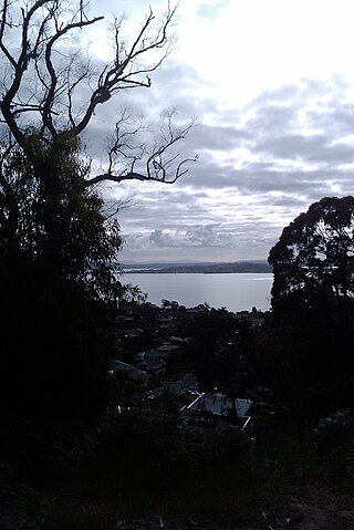
Taroona is a major residential suburb approximately 15 minutes drive from the centre of Hobart, Tasmania on the scenic route between Hobart and Kingston. Although on the edges of the City of Hobart, Taroona is actually part of the municipality of Kingborough. Taroona is bounded on the east by the Derwent River, and has several beaches along the shore, the main beaches with public access are Taroona Beach, Hinsby Beach and Dixons Beach. Past Hinsby Beach, the Alum Cliffs form a section of cliffed coast to the neighbouring suburb of Bonnet Hill.
Cygnet is a town in the Huon Valley, south of Huonville, Tasmania.
Gagebrook is a residential locality in the local government area (LGA) of Brighton in the Hobart LGA region of Tasmania, Australia. The locality is about 9 kilometres (5.6 mi) south of the town of Brighton. The 2016 census recorded a population of 1440 for the state suburb of Gagebrook. It is one of the northernmost suburbs of Hobart, located near the eastern shore of the Derwent River between the suburbs of Bridgewater and Old Beach.

Dynnyrne is a residential locality in the local government area (LGA) of Hobart in the Hobart LGA region of Tasmania. The locality is about 3 kilometres (1.9 mi) south-west of the town of Hobart. The 2016 census recorded a population of 1577 for the state suburb of Dynnyrne.

Clifton Beach is a coastal suburb located approximately 25 km southeast of Hobart on the South Arm Peninsula on the outskirts of Hobart, Tasmania, Australia. It is part of the City of Clarence, and is a popular surfing location.
Bonnet Hill is a residential locality in the local government area (LGA) of Kingborough in the Hobart LGA region of Tasmania, Australia. The locality is about 2 kilometres (1.2 mi) east of the town of Kingston. The 2016 census recorded a population of 505 for the state suburb of Bonnet Hill.
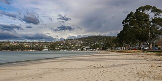
Kingston Beach is a residential locality in the local government area (LGA) of Kingborough in the Hobart LGA region of Tasmania. The locality is about 2 kilometres (1.2 mi) south-east of the town of Kingston. The 2021 census recorded a population of 2305 for the state suburb of Kingston Beach.
Maranoa Heights is a residential neighbourhood of the suburb of Kingston in the greater Hobart area of Tasmania, Australia. It is largely within the southern part of the area contained by the B68 Channel Highway, the C628 Roslyn Avenue and Algona Road. Maranoa Heights contains large areas of recreational woodland accessed by walking tracks and overlooks the coastal suburbs of Kingston Beach and Blackmans Bay. Maranoa Heights is home to the Boronia Hill Flora Track.
Huntingfield is a residential locality in the local government area (LGA) of Kingborough in the Hobart LGA region of Tasmania. The locality is about 3 kilometres (1.9 mi) south-west of the town of Kingston. The 2021 census recorded a population of 540 for the state suburb of Huntingfield.

Kingborough Lions United Football Club is a semi-professional association football club based in Kingston, Tasmania. Founded in 1998, the club currently competes many leagues including in the NPL Tasmania and the Women's Super League. The club has a large playing group ranging and teams range from juniors, youth academy, and social teams through to high performance men and women's programs.
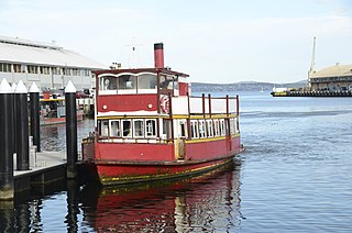
Ferries in Hobart are a form of public transport in the city of Hobart, Tasmania. Though for decades they had not provided a major alternative public transport service for commuters and tourists in Hobart across the Derwent River, a renewed ferry service began in 2021. This has resulted in a revival of ferry transport in Hobart, including long-term plans to expand the network.

Sandy Bay Road is a road in Tasmania that connects the southeastern edge of the Hobart CBD with the southeastern suburb of Taroona. It is two-way over its entirety and is 12 kilometres in length. It begins as a continuation of Harrington Street near where it intersects with Davey Street. From there, Sandy Bay Road travels southwards alongside the western edge of St. Davids Park, bypassing Battery Point. It then turns slightly to the west again, before descending a small hill towards the south-east once more, into Sandy Bay proper. Sand Bay Road then continues south-easterly, hugging the western shore of the River Derwent. Passing Wrest Point Hotel Casino it continues to the south-east along Sandy Bay Beach through Lower Sandy Bay. At the point where the Alexandra Battery overlooks Long Beach, Sandy Bay road follows the coast bending in a more southwards direction. The road then begins to climb uphill towards the suburb of Taroona where it becomes the Channel Highway. The road is allocated route code B68.

The Alum Cliffs are a section of cliffed coast facing the Derwent Estuary and Storm Bay along the suburbs of Taroona, Bonnet Hill, and Kingston Beach, Tasmania, Australia. Composed of Permian mudstone, the cliff formation stretches for 3.5 kilometres (2.2 mi) between Hinsby Beach and Tyndall Beach at Kingston Beach. The cliff face reaches heights of up to 30 metres (98 ft) above sea level and has vistas of the Derwent Estuary, Storm Bay, South Arm and Bruny Island.


