Councils of Tasmania are the 29 administrative districts of the Australian state of Tasmania. Local government areas (LGAs), more generally known as councils, are the tier of government responsible for the management of local duties such as road maintenance, town planning and waste management.

The River Derwent is a river located in Tasmania, Australia. It is also known by the palawa kani name timtumili minanya. The river rises in the state's Central Highlands at Lake St Clair, and descends more than 700 metres (2,300 ft) over a distance of more than 200 kilometres (120 mi), flowing through Hobart, the state's capital city, before emptying into Storm Bay and flowing into the Tasman Sea. The banks of the Derwent were once covered by forests and occupied by Aboriginal Tasmanians. European settlers farmed the area and during the 20th century many dams were built on its tributaries for the generation of hydro-electricity.
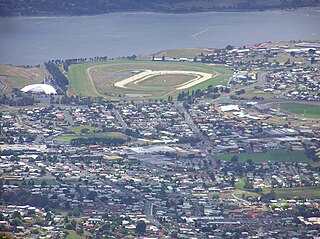
Glenorchy is a suburb of Hobart, in the state of Tasmania, Australia. Glenorchy is bound by the River Derwent to the east, Mount Wellington to the west, Hobart City to the south and Brighton to the north. The city officially begins at Creek Road New Town, in Hobart's northern suburbs, and includes, Moonah, Derwent Park, Lutana, Goodwood, Montrose, Rosetta, Berriedale, Chigwell, Claremont and Austins Ferry. It is the seat of the local government area of the same name, the City of Glenorchy.

Clarence City Council is a local government body in Tasmania, and one of the five municipalities that constitutes the Greater Hobart Area. The Clarence local government area has a population of 61,531, covering the eastern shore of the Derwent River from Otago to the South Arm Peninsula and the smaller localities of Cambridge, Richmond, and Seven Mile Beach.

New Town is a suburb of the city of Hobart, Tasmania, Australia, about 4 kilometres (2 mi) north of the central business district of Hobart. It is generally considered Hobart's oldest suburb, settled just a week after Sullivans Cove. It was historically the home of many of Hobart's wealthiest citizens, and New Town features a large number of grand residences, churches, and public buildings. The large farms were broken up following the world wars and it is now an inner city residential suburb. Many of its streets are lined with Federation style cottages. It is surrounded by the suburbs of North Hobart, Mount Stuart, Lenah Valley and Moonah, with the Queen's Domain just to the south-east. Most of the locality is within the Hobart local government area, with 2.5% within Glenorchy.

The Brooker Highway is a highway in the Australian state of Tasmania. As one of Hobart's three major radials, the highway connects traffic from the city centre with the northern suburbs and is the major road connection to the cities and towns of northern Tasmania. With an annual average daily traffic of 48,000, the highway is one of the busiest in Tasmania. The Brooker Highway has recently been declared part of the National Highway.

Glenorchy City Council is a local government body in Tasmania, and one of the five municipalities that constitutes the Greater Hobart Area. The Glenorchy local government area has a population of 50,411, covering the suburbs north of central Hobart on the western shore of the Derwent River, including its namesake suburb, Glenorchy.
Claremont is a rural / residential locality in the local government areas (LGA) of Glenorchy (75%) and Derwent Valley (25%) in the Hobart and South-east LGA regions of Tasmania. The locality is about 6 kilometres (3.7 mi) north of the town of Glenorchy. The 2021 census recorded a population of 8,397 for the state suburb of Claremont.

Moonah is a residential locality in the local government area (LGA) of Glenorchy in the Hobart LGA region of Tasmania. The locality is about 3 kilometres (1.9 mi) south-east of the town of Glenorchy. The 2016 census recorded a population of 5421 for the state suburb of Moonah. It is a suburb in the city of Hobart, located approximately 5 km north of the central business district of Hobart, and lying directly north of the inner city suburb New Town.

Geilston Bay is a largely residential suburb of Hobart between Risdon Vale, Shag Bay, and Lindisfarne, in the City of Clarence located on the Eastern Shore of the Derwent River, taking its name from an inlet of that river of the same name. The inlet and locality were sometimes known by the alternative name "Limekiln Bay" on account of lime kilns which operated there between approximately the 1830s and the 1920s, the remains of which remained visible for some decades thereafter; another early name for the Bay was "James's Bay". The present suburb name derives from an early land holding "Geils Town" in the region purchased by Andrew Geils, Commandant of Van Diemen's Land (Tasmania) for a brief period in 1812-1813, who subsequently left his Australian holdings behind when he moved back to Scotland.
Rosetta is a residential locality in the local government area (LGA) of Glenorchy in the Hobart LGA region of Tasmania. The locality is about 3 kilometres (1.9 mi) north-west of the town of Glenorchy. The 2021 census recorded a population of 2,833 for the state suburb of Rosetta. It is a suburb of Hobart. The suburb is situated between the suburbs of Berriedale and Montrose and is approximately 15 minutes drive from Hobart. There is a primary school and a high school in Rosetta. The Brooker Highway runs along the eastern border of the suburb, next to the Derwent River.
Montrose is a residential locality in the local government area (LGA) of Glenorchy in the Hobart LGA region of Tasmania. The locality is about 1 kilometre (0.62 mi) north of the town of Glenorchy. The 2016 census recorded a population of 2152 for the state suburb of Montrose. It is a suburb of Hobart. The suburb is situated in close proximity with Rosetta. Montrose is the suburb directly north of Glenorchy. It is also in Montrose where the Montrose Foreshore Community Park is located.

Derwent Park is a residential locality in the local government area (LGA) of Glenorchy in the Hobart LGA region of Tasmania. The locality is about 2 kilometres (1.2 mi) east of the town of Glenorchy. The 2016 census recorded a population of 657 for the state suburb of Derwent Park. It is a suburb of Hobart.
Goodwood is a residential locality in the local government area (LGA) of Glenorchy in the Hobart LGA region of Tasmania. The locality is about 2 kilometres (1.2 mi) east of the town of Glenorchy. The 2016 census recorded a population of 1049 for the state suburb of Goodwood. It is a suburb of Hobart.

Lutana is a residential locality in the local government area (LGA) of Glenorchy in the Hobart LGA region of Tasmania. The locality is about 3 kilometres (1.9 mi) south-east of the town of Glenorchy. The 2021 census recorded a population of 2,616 for the state suburb of Lutana. It is a suburb of Hobart. It is a large residential suburb located between the Brooker Highway and the River Derwent.
Dowsing Point is a residential locality in the local government area (LGA) of Glenorchy in the Hobart LGA region of Tasmania. The locality is about 2 kilometres (1.2 mi) north-east of the town of Glenorchy. The 2016 census recorded a population of 85 for the state suburb of Dowsing Point.

Granton is a rural residential locality in the local government areas (LGA) of Derwent Valley (80%) and Glenorchy (20%) in the South-east and Hobart LGA regions of Tasmania. The locality is about 9 kilometres (5.6 mi) north of the town of Glenorchy. The 2016 census recorded a population of 1736 for the state suburb of Granton. It is a suburb of Hobart. Rust Road is the approximate boundary between the two municipalities at Granton.

Rose Bay is a suburb of the City of Clarence in greater Hobart, capital city of Tasmania, Australia. Rose Bay is a small suburb, making up only approximately 0.9 square kilometres with nearly one fourth of that area (23.2%) being parkland. At the 2016 Census the suburb recorded a population of 1,102 people.

Risdon Zinc Works is a major zinc refinery located in Lutana, a suburb of Hobart, Tasmania, Australia. The smelter is one of the world’s largest in terms of production volume, producing over 280,000 tonnes annually of high-grade zinc, primarily as die-cast alloys and continuous galvanising-grade alloys. These products are exported for global markets and utilised in a wide range of industries and products, from building and infrastructure to transportation, business equipment, communications, electronics, and consumer goods. The facility produces zinc using the Roast, Leach, Electrowinning (RLE) method, creating leach byproducts, including cadmium, gypsum, copper sulphate, lead sulphate, sulphuric acid, paragoethite and leach concentrate. The refinery has been owned and operated by the global multi-metals business Nyrstar since 2007. Nyrstar Hobart works closely with the Nyrstar Port Pirie multi-metals smelter in South Australia. The facility is Tasmania's largest exporter, contributing 25% of the state's overall export value in 2013.

The Glenorchy Art and Sculpture Park (GASP) is a sculpture park and boardwalk in Glenorchy, Tasmania, Australia. Commencing at Montrose Foreshore Community Park, GASP follows Elwick Bay's foreshore, terminating at Wilkinsons Point. GASP is in close proximity to the MyState Bank Arena, Elwick Racecourse and the Museum of Old and New Art (MONA) in Berriedale.


